DJI Mavic, Air and Mini Drones
Friendly, Helpful & Knowledgeable Community
Join Us Now

Disconnected and Gone....Any tips on where to look?

CH26

Active Member
Joined
Mar 13, 2017
Messages
29
Reactions
16
Age
36
Location
Eastern Oregon
Sorry to be another frantic soul in search of help (and a $1000 drone), but I am.

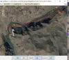
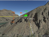
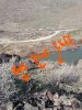
I was flying up in the canyon near my house and flew following the river around a bend the drone disconnected after a frantic buckle in of my 2 yr old and loading the dog we sped off down the road to try and get reconnected. It took probably 2-3 minutes to get to the location it disconnected after looking for 5 minutes we went back to the home spot.....no dice. So we waited until night to see if we could see the lights. Nothing. WE couldn't cross the river, and all the crossings are washed out for miles. Tomorrow I'm going to buy a boat at Walmart and see if it landed just on the other side or up the hillside.

Would it have continued on its trajectory? Would it just land when it lost connection? If I read the manual right it should come home. But it didn't

Any help is big a help.

Thanks.

I will try and attach the TXT file.
 

Attachments

  • DJIFlightRecord_2017-03-12_[18-41-25][1].txt
    599.2 KB · Views: 56
I'd be looking on this hillside.

upload_2017-3-13_20-1-8.png

You had your return to home set at 30m and that hill is at least 100m above the river where you took off.
 

Attachments

  • upload_2017-3-13_20-0-16.png
    upload_2017-3-13_20-0-16.png
    583.3 KB · Views: 200
upload_2017-3-13_20-14-43.png

You were flying at 55m above your takeoff alt when you lost signal. It would have flown on for 3 seconds & then turned for home. and remained at 55m. Because you were already above your 30m programmed height. As it did not arrive home it is very likely that it flew into the side of that hill at 55m above your take of point. Perhaps obstacle avoidance was not active..
 
  • Like
Reactions: CH26
upload_2017-3-13_20-37-40.png
That point is 55m above your home point so would be a good place to look
43°43'49.85"N 117°12'5.72"W
 
Your Mavic had plenty of battery power left after it disconnected from the remote controller, so it would have made it home if it had cleared the hill. It most likely either crashed into the side of the hill and is hanging on the side of it somewhere or it tumbled down the hill into the following area:

CrashSite.jpg
 
  • Like
Reactions: OleBoy and CH26
I reckon it would have cleared the cliffs and be on the spur above them. If you can get hold of a watch with an altimeter, zero it at your home point, climb the spur to 55m (180') indicated and use this as a countour line to search. Looks like you may have only been a few metres short of clearing the ridge and getting home.
 
I reckon it would have cleared the cliffs and be on the spur above them.
What are you seeing in the log that's telling you it cleared the cliffs?
 
  • Like
Reactions: CH26
What are you seeing in the log that's telling you it cleared the cliffs?

hSpeed and altitude vs Google Earth. But how long after the 3 sec LOS trigger it actually sets course home is a bit of a guess. As is exactly how steep the side of the mountain actually is without being there.

upload_2017-3-14_1-1-27.png


upload_2017-3-14_1-11-30.png
This image is rotated 90 degrees. Horizontal line being aircraft actual path at exact aircraft height. It travelled left to right around the bend until signal loss. Second line shows approx RTH ground track from 5 sec after LOS. Allowing for trigger at 3 sec and a 2 sec response to stop and turn. Where those two line bisect is where I would look. Appears it would be easier to climb the spur at the end of the hill than following the return path up the steep section.
 

Attachments

  • upload_2017-3-14_0-59-52.png
    upload_2017-3-14_0-59-52.png
    1.6 MB · Views: 158
Take some pics of your travel attempts to find it and then of the Mavic when you find it. Video would be a good way also to document your mission!
 
Question: did you think your RTH with high enough at 30m?

or was that low of a RTH setting just an oversight?
 
I want to thank you all again. The response I got was fast and frankly astonishing. Thank you for your expertise and willingness to help.

We just got back from our adventure it took us a hour or so to hike in. We found it within 5 minutes of being in the area you described. The battery fell out on impact. The rear props are demolished and the rubber peices that the gimbal dangles from popped out on one side.


Bonus question. The video from the crash is on the card (it has a large file size) but it wont pull up on my computer. Any suggestions?
 

Attachments

  • Dronecrash.jpg
    Dronecrash.jpg
    6.4 MB · Views: 328
  • Inked20170313_134118_LI.jpg
    Inked20170313_134118_LI.jpg
    4.9 MB · Views: 321
  • Screenshot_2017-03-13-15-14-36[1].jpg
    Screenshot_2017-03-13-15-14-36[1].jpg
    1.1 MB · Views: 292
  • Screenshot_2017-03-13-15-15-27[1].jpg
    Screenshot_2017-03-13-15-15-27[1].jpg
    2.6 MB · Views: 292
  • Screenshot_2017-03-13-15-16-31[1].jpg
    Screenshot_2017-03-13-15-16-31[1].jpg
    1.7 MB · Views: 301
Lycus Tech Mavic Air 3 Case

DJI Drone Deals

New Threads

Forum statistics

Threads
131,000
Messages
1,558,754
Members
159,985
Latest member
kclarke2929