DJI Mavic, Air and Mini Drones
Friendly, Helpful & Knowledgeable Community
Join Us Now

For Sale - $1000 Mavic Pro Paperweight

Tazerdog

Member
Joined
Jun 11, 2017
Messages
20
Reactions
18
Age
69
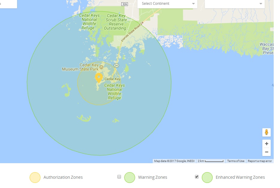
Greetings from Cedar Key Florida! On vacation for a beautiful weekend getaway to a place unknown to most. Google it. Once again I take my Mavic along hoping to get some beautiful aerial footage but ...... nooooooo! You ain't taking off Bubba. You are in a NFZ. Not one of those, hey there is a runway in the area, so be responsible and check the box saying u will, then b on your way type things. One of those red, you aren't taking off no matter what type warnings. Because u r in the vicinity of an airstrip that on a good day may see 6-12 small aircraft landings. There is more business on most grass strips. There isn't even a building on a hangar that are part of this strip. Bottom line, everyone knows it's there and takes precautions. Except for those attempting to fly a Mavic. Once again I smartly brought my Pro 3 along, fired it up with no problems and flew. I'm not the smartest guy on the block but I've been flying drones for years responsibly; Vision 2+, Pro 3, and now the Mavic. Well not really the Mavic cause most places I can't fly because I'm either in a NFZ or I can't fly until I update to the 75th and latest firmware that takes a half a day to download and install. I bought it on a whim. Was totally satisfied with the Pro 3 that BTW I've done 1" software upgrade in a year and a half. If anyone has any great ideas, please pass along. Otherwise, I'm cutting my losses with this rock. Currently my app is 4.1.2, the drone is Ver 1.03.0800, and the DB is Ver 1.00.01.04
 
What was the main location you liked about Cedar Key?

Google Maps

Have you been to Cedar Keys National Wildlife Refuge? If so did you rent a boat to get there?
 
According to GEO, most of Cedar Key is an Enhanced Warning zone, you will be prompted by GEO at the time of flight to unlock the zone using the same steps as in an Authorization Zone, but you do not require a verified account or an internet connection at the time of your flight.

Within a two mile radius of the airstrip however will require you to authenticate- this may be unlocked by authorized users using a DJI verified account.
 
All: 1st of all, the key itself (with land and streets) is only about 2 miles across. I tried flying on the farthest point from the airstrip with the same results. Maybe I'm missing something but if u get a red NFZ warning, vs a yellow, game is over right?
 
Agreed... yes Red is game over. But it doesn't show Red on the DJI Map- online shows outer Green and inner Yellow. Do you have GEO disabled on your device perhaps?
 
Here's the online map. I'd sure like to understand why you device shows it as Red. Geo disabled? Do you have internet connectivity from where you are trying to fly?

DJIMap.jpg
 
According to GEO, most of Cedar Key is an Enhanced Warning zone, you will be prompted by GEO at the time of flight to unlock the zone using the same steps as in an Authorization Zone, but you do not require a verified account or an internet connection at the time of your flight.

Within a two mile radius of the airstrip however will require you to authenticate- this may be unlocked by authorized users using a DJI verified account.

Can you clarify what you mean by authenticating? I have a DJI verified account
 
Here's the online map. I'd sure like to understand why you device shows it as Red. Geo disabled? Do you have internet connectivity from where you are trying to fly?

DJIMap.jpg

I had internet connectivity at the house when I got red. Probably not over by the docks because cell service is pretty spotty on this key and I don't think they have cable here. Looks like most people use satellite for both TV and Internet
 
I had internet connectivity at the house when I got red. Probably not over by the docks because cell service is pretty spotty on this key and I don't think they have cable here. Looks like most people use satellite for both TV and Internet
If you have spotty internet at launch, it's likely unable to authorize your flight. You would need to pre-authorize it on DJI's GEO page and load it into Go. Then it will let you take off.
 
Here's the online map. I'd sure like to understand why you device shows it as Red. Geo disabled? Do you have internet connectivity from where you are trying to fly?

DJIMap.jpg

HFMan. Correction. I am showing exactly what u show on the map but when I go to the fly screen, I have a red bar across the top and I get a red triangle for NFZ if I go for additional details
 
Your Phantom 3 is also antiquated. DJI no longer maintain those.

Antiquated? I beg to differ. Anything a Mavic can do, a Phantom can do better; photography, stability in wind, etc.

The Only thing a Mavic is better than a Phantom is portability. No a Phantom can't be packed up and shoved in your pocket to carry anywhere.

But u can bet that it will fly when u get there.
 
Lycus Tech Mavic Air 3 Case

DJI Drone Deals

New Threads

Forum statistics

Threads
131,086
Messages
1,559,701
Members
160,068
Latest member
Bahamaboy242