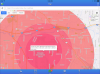
So DJI's Geo system will prevent you from taking off in or flying into an "Authorization Zone" until you "unlock" the area. Both of these scenarios assume the drone has a GPS signal and can report your location to DJI's geo system. But apparantly if you take off in an AZ and later the GPS signal is acquired while in the air the firmware takes control of your craft and flies it off radially away from the center of the AZ. At least thats been my experience.
After it happened to me the first time I went back the next day to the exact same spot and retraced my every step with the exact same results. No gps signal on the ground, took off to a height of about 3 feet, GPS signal acquired, and then simultaneously I got the AZ message and the drone flew off full throttle.
What concerns me is it flew off without any regard to altitude or obstacles (as it didn't yaw in the direction of flight). It wouldn't let me bring it back to the home point but pulling the stick in the opposite direction stopped its travel, and letting it go it would continue to fly off radially away from the center of the AZ.
Now perhaps there's a different explanation for the Mavic's behavior but I fail to see one. If this is intentional on the part of the firmware then that pretty much sucks! Granted you're flying in a AZ but to cause the craft to fly off to who knows what final destination seems nuts.
Seems like a bug to me. Hopefully someone can shed some light on this but in the meantime do your best to acquire a GPS signal before taking off. Move the drone around if you have to.