DJI Mavic, Air and Mini Drones
Friendly, Helpful & Knowledgeable Community
Join Us Now

RTH didn't worked and Mavic is lost

Cesarr04

Member
Joined
Apr 23, 2017
Messages
6
Reactions
15
Age
36
Hi guys

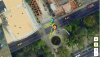
Sadly yesterday I lost my Mavic, it was hoovering over me at 380m (1246 ft aprox) in a large space between three skyscrapers (all of them bellow 250m tall or 820ft) when I lost the connection. Before loosing the connection I pressed the RTH button (set at 300m) however, despite the home point was set and all the sensors were enabled the drone never returned back, I moved from my position in order to re gain control of the drone, but I never got contact with the drone again. Arter 40 min of despair and anguish I never saw again the drone.

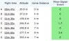
I've checked the logs of the drone, it said there was strong interference seconds before the lost. The sequence of the connection was the following: GPS-P, Wifi, lost connection (one second), GPS-P, Wifi. After this nothing but the lost of the drone. Having set the home point and the sensors were enabled, what could possibly be the reason of why the drone never came back? Could this be attributed to a system malfunction? I'm aware that it was too high and I were in the centre of the city where the interference is higher, but I still don't know why it never came back.

Regards.
 

Attachments

  • DJIFlightRecord_2017-04-22_[19-40-56].txt
    694.6 KB · Views: 81
  • Captura de pantalla 2017-04-23 a la(s) 18.12.30.png
    Captura de pantalla 2017-04-23 a la(s) 18.12.30.png
    22.5 KB · Views: 415
  • Captura de pantalla 2017-04-23 a la(s) 18.11.25.png
    Captura de pantalla 2017-04-23 a la(s) 18.11.25.png
    50.5 KB · Views: 449
  • Captura de pantalla 2017-04-23 a la(s) 18.11.10.png
    Captura de pantalla 2017-04-23 a la(s) 18.11.10.png
    431.2 KB · Views: 454
I looked at it real quick, and the answer is, I don't know. I'll have to give it a closer look tomorrow morning. I'll note that flying next to Helipads is not the smartest idea, but I can't see pilot error yet, but I'm also not yet claiming malfunction.
 
  • Like
Reactions: Butterfingers
Actually I think I know what happened. Did your RC ever say connecting on the display, or was it still displaying telemetry? If so, when your RC beeping when you activating the RTH? Was your phone reporting a grey disconnected bar in the app, or a red disconnected bar in the app?
 
  • Like
Reactions: Rbruz and MLR
Actually I think I know what happened. Did your RC ever say connecting on the display, or was it still displaying telemetry? If so, when your RC beeping when you activating the RTH? Was your phone reporting a grey disconnected bar in the app, or a red disconnected bar in the app?

Yes, RC displayed the "connecting" message as well as the telemetry, but it only showed the same data before the loss (the battery had about 86% or 20 min left). To be honest I do not remember if I heard the beeping sound at the same moment when I activated the RTH, I was really scared at that moment I only remember trying to find a better spot to made contact with it, but I do remember to heard it two or three minutes after. The phone had a red disconnected bar.

I know that it was not wise to fly near skyscrapers with helipads, that was totally my fault, but my point is why the drone didn't came back after it loss the signal from the RC.

Thanks!
 
  • Like
Reactions: Reknolp
I think this is the biggest fear among drone pilots here on the forum. Are you sure you confirmed the rth right after takeoff? Was there the possibility of a collision? And in the log, did you try to see the last coordinate?
 
  • Like
Reactions: Rbruz
Yes, RC displayed the "connecting" message as well as the telemetry, but it only showed the same data before the loss (the battery had about 86% or 20 min left). To be honest I do not remember if I heard the beeping sound at the same moment when I activated the RTH, I was really scared at that moment I only remember trying to find a better spot to made contact with it, but I do remember to heard it two or three minutes after. The phone had a red disconnected bar.

I know that it was not wise to fly near skyscrapers with helipads, that was totally my fault, but my point is why the drone didn't came back after it loss the signal from the RC.

Thanks!

Were you flying in RC mode or Wifi mode? Seems unusual that it would refer to Wifi if you were in RC mode.
 
  • Like
Reactions: Rbruz
I had a quick view on the flight records.
Here is my interpretation:

0.6s Starting Motors, alongside with Warning: The aircraft is in a Warning Zone (Class D). Fly with caution here.
1.2s Manual Takeoff - only 5 sats locked - GPS Health 0
Aircraft climbing
14.9s Warning: [compass]magnetic interfered (In Flight) please switch to atti mode if craft behave abnormally (Using)
This maybe caused by the environment the aircraft was within (Skyscraper, other high rise buildings)
17.6s Warning: Max Altitude Approached. Wait for the GPS satellite signal recovery before ascend.
8 sats locked, IMU height 14.1ft (4.2m)
Saftey measures kick in. As insufficient sats locked in, pilot should have waited until enough sats are locked.
Aircraft climbing
41.6s at 94.2ft (28.7m) Warning: Max Flight Altitude Reached. Adjust in Main Controller Settings if necessary
I think a default setting (or old height restriction) of the GO4 app kicks in, preventing the aircraft from further
climbing. (maybe pilot adjusted to his need and increased max. height setting)

Aircraft climbing
between 42s and 48s 10 Sats locked. GPS health 4
49.6s at 97.1ft (29.59m) the Home Point has been recorded. RTH altitude was 300m. RTH coordinates were, according to
CSView Lat 19 Long -99 (19°0'0''N, 99°0'0''W)
At the same time the app coordinates were: Lat 19,42432 Long -99,174423
I assume that the pilot did not move very far away from his take off (TO) place, the difference between TO and Mavics
RTH coordinates is now approx. 50 km SSE from the launch point.

58.9s - 1m2.7s Flight controller GPS PositionNoMatch
Now IMU/Compass and GPS disagrees on the current postion.
Aircraft climbing until 2m20s
Aircraft at the same height until 2m50s
Aircraft climbing
3m29.3 Warning: Strong Interference to Aircraft. Signal interruption may be more likely. Fly with caution.
Maybe first indication that the antennas of the RC are not properly aligned.
3m33.2 1194ft (363m) Warning: Weak signal. Adjust antenna and avoid signal block

3m36 and 3m42s Downlink restored
Also an indication that RC and aircraft exceed, or are close to their comm limits.
3m42.4m Log end

I assume that the aircraft initiated RTH after RC comm lost, flying SSE to the RTH point the Mavic
wrongly set.
As the pilot was beeing in a magnetic distored aerea he should not have taken off with GPS health 0.
As Google earth shows the launch point is surrounded by high rise buildings, the RC antenna was not
properly aligned to establish good communication to the aircraft, it was impossible to regain control
after the Mavic initiated RTH.
While RTH the battery would be depleted at some point, a forced landing will bring the Mavic back on the ground somewhere SSE.

Sorry for your loss, i hope you will find it.
-K

edit: typo
 
Last edited:
So flying between buildings is allowed in some countries and cities
 
Yes, RC displayed the "connecting" message as well as the telemetry, but it only showed the same data before the loss (the battery had about 86% or 20 min left). To be honest I do not remember if I heard the beeping sound at the same moment when I activated the RTH, I was really scared at that moment I only remember trying to find a better spot to made contact with it, but I do remember to heard it two or three minutes after. The phone had a red disconnected bar.

I know that it was not wise to fly near skyscrapers with helipads, that was totally my fault, but my point is why the drone didn't came back after it loss the signal from the RC.

Thanks!
That shoots my theory down. Looking further...
 
I had a quick view on the flight records.
Here is my interpretation:

0.6s Starting Motors, alongside with Warning: The aircraft is in a Warning Zone (Class D). Fly with caution here.
1.2s Manual Takeoff - only 5 sats locked - GPS Health 0
Aircraft climbing
14.9s Warning: [compass]magnetic interfered (In Flight) please switch to atti mode if craft behave abnormally (Using)
This maybe caused by the environment the aircraft was within (Skyscraper, other high rise buildings)
17.6s Warning: Max Altitude Approached. Wait for the GPS satellite signal recovery before ascend.
8 sats locked, IMU height 14.1ft (4.2m)
Saftey measures kick in. As insufficient sats locked in, pilot should have waited until enough sats are locked.
Aircraft climbing
41.6s at 94.2ft (28.7m) Warning: Max Flight Altitude Reached. Adjust in Main Controller Settings if necessary
I think a default setting (or old height restriction) of the GO4 app kicks in, preventing the aircraft from further
climbing. (maybe pilot adjusted to his need and increased max. height setting)

Aircraft climbing
between 42s and 48s 10 Sats locked. GPS health 4
49.6s at 97.1ft (29.59m) the Home Point has been recorded. RTH altitude was 300m. RTH coordinates were, according to
CSView Lat 19 Long -99 (19°0'0''N, 99°0'0''W)
At the same time the app coordinates were: Lat 19,42432 Long -99,174423
I assume that the pilot did not move very far away from his take off (TO) place, the difference between TO and Mavics
RTH coordinates is now approx. 50 km SSE from the launch point.

58.9s - 1m2.7s Flight controller GPS PositionNoMatch
Now IMU/Compass and GPS disagrees on the current postion.
Aircraft climbing until 2m20s
Aircraft at the same height until 2m50s
Aircraft climbing
3m29.3 Warning: Strong Interference to Aircraft. Signal interruption may be more likely. Fly with caution.
Maybe first indication that the antennas of the RC are not properly aligned.
3m33.2 1194ft (363m) Warning: Weak signal. Adjust antenna and avoid signal block

3m36 and 3m42s Downlink restored
Also an indication that RC and aircraft exceed, or are close to their comm limits.
3m42.4m Log end

I assume that the aircraft initiated RTH after RC comm lost, flying SSE to the RTH point the Mavic
wrongly set.
As the pilot was beeing in a magnetic distored aerea he should not have taken off with GPS health 0.
As Google earth shows the launch point is surrounded by high rise buildings, the RC antenna was not
properly aligned to establish good communication to the aircraft, it was impossible to regain control
after the Mavic initiated RTH.
While RTH the battery would be depleted at some point, a forced landing will bring the Mavic back on the ground somewhere SSE.

Sorry for your loss, i hope you will find it.
-K

edit: typo
Keule,
Where did you find the information about the RTH coordinates been updated to (19°0'0''N, 99°0'0''W) ? I just found the information that the home point was recorded.
Regards.
 
from CSView. (CsvView Introduction)

i am interpreting the data as follows:
at 46.899 gpsHealth was 2, even 10 satellites locked. HOME.latitude and HOME.longitude had undefined data in the fields.

gpsHealth2.JPG

short after gpsHealth reached 4, both HOME fields are being populated. Mavics flight controller responded with 'Home Point set ...' at 49.6s

gpsHealth4.JPG
 
  • Like
Reactions: Slackhawk
from CSView. (CsvView Introduction)

i am interpreting the data as follows:
at 46.899 gpsHealth was 2, even 10 satellites locked. HOME.latitude and HOME.longitude had undefined data in the fields.

View attachment 11505

short after gpsHealth reached 4, both HOME fields are being populated. Mavics flight controller responded with 'Home Point set ...' at 49.6s

View attachment 11506

That might just be rounded up in CsvView. When I look at the raw data in the CSV, at 49.6s it shows:

Aircraft co-ordinates: 19.42428149 -99.17444159
Home co-ordinates: 19.42428244 -99.17443763
 
The last line in your logs shows the Mavic as being 6.7m away from the recorded Home Point. The Mavic may well have moved a little bit after the signal loss, bringing it within 5m of the Home Point. In that case, RTH due to signal loss would cause it to land immediately, rather than move to the Home Point. Is it possible the Mavic landed on one of the nearby buildings?
 
That might just be rounded up in CsvView.

Yes, you are right. Just had a look at the raw data.
I wondered myself already why the program displays the coordinates as pure integers.

OT:
Just looked at my flights from this morning. All coordinates displayed correct.

Regards,
-K
 
So, if I'm understanding it correctly, when MP goes beyond 400' and lose GPS/Satellite and after a few moment and regaining both signals it will set a 2nd HP?
Expert pilots please chime in.
 
So, if I'm understanding it correctly, when MP goes beyond 400' and lose GPS/Satellite and after a few moment and regaining both signals it will set a 2nd HP?
Expert pilots please chime in.
Not sure exactly what you mean but basically no, the Mavic will never set a new Home Point unless you tell it to. In this case the Home Point was set for the first time at 49s because it never had enough GPS data to set one prior to that.
 
  • Like
Reactions: Rbruz
Lycus Tech Mavic Air 3 Case

DJI Drone Deals

New Threads

Members online

Forum statistics

Threads
131,091
Messages
1,559,739
Members
160,075
Latest member
Gadget61