DJ Wes's latest activity
-
 DJ Wes replied to the thread Help needed to verify and fine tune a GSD Calculator.I can see you changed the sensor size to be the active area of the sensor as @Theta has provided. However, your calculated horizontal and vertical FOV differ from my calculations. I describe how to calculate them here...
 -
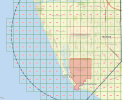
DJ Wes replied to the thread Is LAANC actually permitted here?.That is normal for a LAANC grid. There are always portions with a zero height restriction meaning that you cannot fly in that portion without a waiver (Part 107 only). That particular region is listed as "Naval CBC Port Hueneme":
-
-
DJ Wes replied to the thread Litchi Hub Missions.Yes. Litchi has a new Mission Hub in Beta. They have added the option to export the mission as a DJI KMZ file. This file may be uploaded to a DJI Fly drone (that has waypoint support) so that you can fly the mission. The KMZ upload process is...
-
DJ Wes reacted to swoermck's post in the thread Can you edit the exported waypoint kmz file? with
 Like.
I recently created a detailed video describing how to edit waylines.wpml: Idea behind it: modify the waypoint mission to get straight lines again, as nowadays waypoint missions have always curved lines
Like.
I recently created a detailed video describing how to edit waylines.wpml: Idea behind it: modify the waypoint mission to get straight lines again, as nowadays waypoint missions have always curved lines -
DJ Wes replied to the thread Help needed to verify and fine tune a GSD Calculator.I have spent some time gathering sensor sizes for DJI drones for use in my own GSD calculator. While there is no definitive source, I have found several different values provided for sensor size: Nominal (this value is sometimes advertised as...