DJI Mavic, Air and Mini Drones
Friendly, Helpful & Knowledgeable Community
Join Us Now

3D Mapping Software

johnwyork

New Member
Joined
Jan 27, 2020
Messages
3
Reactions
0
Age
56
Location
Arab, AL
I just got my Mavic Mini 2 days ago and have really enjoyed it so far. The pictures are really, really nice, as well as flying it around with the controller. I was hoping to be able to use Drone Deploy software with the Mavic Mini, but it is not supported.

I am not looking for a lot of mapping applications, just really wanting to map my office and my home, really just to do it.

Can anyone recommend any software similar to Drone Deploy where I can use that with the Mavic Mini?

Thanks in advance!

John York
 
Can anyone recommend any software similar to Drone Deploy where I can use that with the Mavic Mini?
None of the mapping service providers are supporting the MM - DJI has to release the SDK first.
 
  • Like
Reactions: pelagic_one
Thanks for the reply! Since this is an entry level drone, do you think DJI will release that at some point?
 
You can fly it manually and find somewhere online to stich the map together. It's not impossible. I did it with webODM. Just make sure to get clear pictures.
 
Unless something has changed, the initial tests indicated that the Mavic Air and now Mavic Mini will not perform mapping tasks to a satisfactory degree to warrant support at least from MapsMadeEasy. Maybe DroneDeploy has other ideas.

Some have reported that the MM potentially has some type of "rounding" issue that prevents or at least inihibits accurat geotagging per some other forums I bounce around on. Unless that's been fixed it was noted as causing errors of approximating 90 in Lat/Lon.

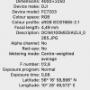
I have full coordinates on my MM photos :)
 
I have full coordinates on my MM photos :)


Can you note how many decimal places are included in the "seconds" portion of the coordinates? It's possible they have fixed the rounding issue but at some point they were rounding to a whole second which is unacceptable for mapping of any kind except "making art".

For accurate mapping you'll want at least (3) decimal places and (4) would be even better.
 
Sure thing, I have 3 decimals.
That's a big step forward!! That should get reasonably close but it won't work for "measuring" if they are looking for dead on accuracy. I'd say it will work for 75% of everything it will be used for.

Now for DJI to release the SDK so DD and MME can start tweaking their programs to include it (maybe?).
 
  • Like
Reactions: Thomas B
Lycus Tech Mavic Air 3 Case

DJI Drone Deals

New Threads

Forum statistics

Threads
130,989
Messages
1,558,680
Members
159,981
Latest member
bbj5143