DJI Mavic, Air and Mini Drones
Friendly, Helpful & Knowledgeable Community
Join Us Now

A Collections Of 360° Panos

sancap

Well-Known Member
Joined
Jan 1, 2017
Messages
156
Reactions
208
Location
Sanibel, Florida
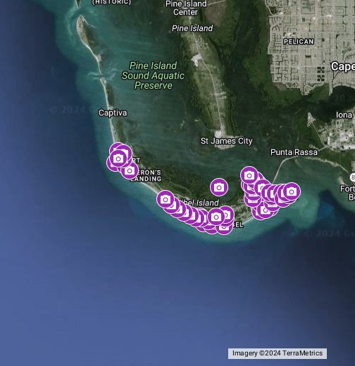
I am working on a project where I am blanketing the Island I live on with aerial panos. I have 40 completed so far and probably have another 20-25 to go. Certain parts of the island are no fly due to A National Wildlife Refuge. This was all done with my Mavic 2 Pro. Comments are welcome.

 
I'm gonna leave commenting for the others, all I can do is commend your effort. This is great.
 
  • Like
Reactions: sancap
That is simply amazing sancap. Your website is one of the best I've seen. Been an aerial lover my whole life.
 
  • Like
Reactions: sancap
This is great stuff. I am working with landscape pans and would be grateful for your advice such as: what is your preferred altitude for image acquisition, the stitching software that you are using and what kind of output, and (for your web site) what host are you using that allows posting of the high resolution of your images?

Thanks,
Howard

Thanks! For these panos I chose 350 feet. For stitching I use PTGui and AutoPano Pro which is no longer available. After stitching I use photoshop to correct the missing part of the sky. After i complete the sky I bring the jpg file into another program that is no longer available called PanoTour Pro. In that program I can add a description, hot points and logos if needed. I then upload the 2 files it creates to my Amazon S3 server which creates a URL that can be easily shared.
 
  • Like
Reactions: CraigObe
Thanks! For these panos I chose 350 feet. For stitching I use PTGui and AutoPano Pro which is no longer available. After stitching I use photoshop to correct the missing part of the sky. After i complete the sky I bring the jpg file into another program that is no longer available called PanoTour Pro. In that program I can add a description, hot points and logos if needed. I then upload the 2 files it creates to my Amazon S3 server which creates a URL that can be easily shared.
Cool! A couple of questions. If you are using the Automated M2P 360° Pano mode, are you saving the originals as JPG or DNG? Have you found the camera created Pano image to be too low in quality to use? Are you using the PTGui export to web for the final output? Have you tried PanoramaStudio 3 Pro? It has a similar interactive mapping feature integrated into the interface for only $80. No affiliation. Just a happy customer.
 
  • Like
Reactions: sancap
Cool! A couple of questions. If you are using the Automated M2P 360° Pano mode, are you saving the originals as JPG or DNG? Have you found the camera created Pano image to be too low in quality to use? Are you using the PTGui export to web for the final output? Have you tried PanoramaStudio 3 Pro? It has a similar interactive mapping feature integrated into the interface for only $80. No affiliation. Just a happy customer.

I am shooting in RAW then converting to jpg in photoshop. I do use the automated pano mode in the go4 app but do not use the pano it creates. I just take the stills created. I have not tried Panorama Studio, I will check it out.

I use Panotour pro to output the data for the web.
 
  • Like
Reactions: GadgetGuy
Hi GadgetGuy, I use PanoramaStudio 3 Pro and I am very happy with the results. I shoot RAW and convert to jpg using DxO PhotoLab 3. Still working on the right settings under different lighting conditions but have had some good results
 
  • Like
Reactions: GadgetGuy
Hi GadgetGuy, I use PanoramaStudio 3 Pro and I am very happy with the results. I shoot RAW and convert to jpg using DxO PhotoLab 3. Still working on the right settings under different lighting conditions but have had some good results
I use the mapping mode in PanoramaStudio 3 Pro, and did try shooting DNG, but PS3P can't read the M2P DNG metadata for the GPS location, so I switched back to using jpgs only, and still have excellent results, without doing a bunch of copying and pasting from the created jpg.. Flat lighting works best, on clear overcast days, so no hot spots. The M2P camera-created pano with stitched ceiling is great for seeing how the pano worked out, and is often good enough on its own, unless you want to be able to zoom in with finer detail, as I do. I set the output quality to 100% which results in a 75MB output file.
 
I am shooting in RAW then converting to jpg in photoshop. I do use the automated pano mode in the go4 app but do not use the pano it creates. I just take the stills created. I have not tried Panorama Studio, I will check it out.

I use Panotour pro to output the data for the web.
Thanks for clarifying. Same here, except I use jpg for the 26 stills. My one gripe with Panorama Studio 3 Pro is that the google map can't be used full screen, which your Panotour Pro interface offers. Too bad it isn't available any more.
 

DJI Drone Deals

New Threads

Forum statistics

Threads
131,096
Messages
1,559,801
Members
160,079
Latest member
calezu