DJI Mavic, Air and Mini Drones
Friendly, Helpful & Knowledgeable Community
Join Us Now

Aircraft not connected to RC - Warranty claim

DJIMINISE123

Member
Joined
Mar 22, 2022
Messages
7
Reactions
1
Age
37
Location
Sydney
Really need help on this one - only had the drone 6 days - 50min flight time.

I have attached the DJI Flight record.

At a distance of ~490m i get a few sudden errors which I could not gather/read fast enough because it was flicking on and off however, it started the RTH count down and within 3 seconds the red Aircraft disconnected from RC error came up. At this point I thought it was either going to return or reconnect to the RC so I waited - neither happened.

I know for a fact my setting was set to RTH as failsafe option as this was the reason I even bought a drone.

I have tried to claim this under warranty as 1. it did not RTH 2. drone is losing being disconnected from RC even with full GPS and satellite signals?

I am new the drone flying obviously, am I right in thinking this is a technical issue with the drone?

Below is the response I received when I lodged the warranty and sent flight data. Now awaiting their response to what I have mentioned.

--------------------------------------------------------------

Dear Customer,

Thanks for your patience.

This is Dora from the data analysis team, and I will be assisting you on this case from now on for related inquiries about data analysis.

For your case CAS-8594730-N1Y1V6, we have finished the analysis, and the result is as follows:

1. The aircraft worked under GPS mode mainly in this flight;
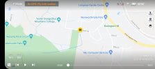
2. Flight Time T=05:01, Relative Height H=125.5 m, Distance to Home Point D=494.8m, the flight record ended;
3. The pre-set failsafe action was landing. The aircraft would land directly after losing the remote connection and finally land at an improper place;
4. The last point: -33.7287079, 150.3764767.

According to the analysis, the incident was not caused by any product issue. Please set a proper Failsafe action before a flight.
 

Attachments

  • DJIFlightRecord_2022-03-19_[18-28-38].txt
    772.3 KB · Views: 31
The TXT log is the definitive "what happened."

For starters, you launched without a home point set due to inadequate GPS signals. Then there were a few GPS position mismatches that hint at more weak signal issues or perhaps a problem with magnetic interference at the launch site. And, DJI is correct, the app was set to land.

MC.failSafeAction: Land

About four minutes 21 seconds into the flight you were given a WEAK RC signal warning. You continued flying away from the launch point, and actually going from 900 feet away to 1600 feet away when at 4:47 you lost the link.

I concur with DJI this was pilot error.

1647953777849.png
 
  • Like
Reactions: MaxE1955!
Before take off their was a home point set though - attached screenshot.

Is this a system issue that my failsafe changed to land? do you need to change it before every flight? i only use RTH

In an event where you get a weak signal for 1 second, but reconnects instantly, arent you able to continue flying as the specifications allows for 2km distance?

The whole flight the GPS and satellites were perfect, so thought i was in the clear?
 

Attachments

  • Screenshot_20220323-002459.jpg
    Screenshot_20220323-002459.jpg
    920 KB · Views: 31
You do not need to set it before every flight, it stays as set and RTH is the default, so you must have changed it yourself at some point, or not had a home point at any time in the flight.
 
Last edited:
How come when when all the errors occured, it popped up with a count down timer notifying me RTH will automatically happen in 10seconds then started to count down prior to losing signal
 
It will start whatever failsafe function that is set. Pretty certain since you never had a home point set that the failsafe only had one choice: LAND.

Most tools will show the launch location as the home point, regardless of one actually being set. Since the log shows there was never a home point set after launch, which always happens if there are sufficient GPS resources available, you never had one. I might be wrong, but I trust the log.

I think rushing a launch without GPS is something most drone flyers have done at one point. But since most such launches end in some sort of disaster, we learn quickly and we don't do it again.

Here's what that Homepoint Update looks like in the log: compare this to your launch - no GPS signal. Without GPS, a home point can't be set.
1647957847310.png

ps: here's an example of a log where there is no actual home point, yet PhantomHelp claims there is:
1648235319063.png
 
Last edited:
It will start whatever failsafe function that is set. Pretty certain since you never had a home point set that the failsafe only had one choice: LAND.

Most tools will show the launch location as the home point, regardless of one actually being set. Since the log shows there was never a home point set after launch, which always happens if there are sufficient GPS resources available, you never had one. I might be wrong, but I trust the log.

I think rushing a launch without GPS is something most drone flyers have done at one point. But since most such launches end in some sort of disaster, we learn quickly and we don't do it again.

Here's what that Homepoint Update looks like in the log: compare this to your launch - no GPS signal. Without GPS, a home point can't be set.
View attachment 145588
Thanks for the reply - makes sense.

Seems like I need a pilot degree to operate this thing in future. Thought this product is for everyone already, guess not I lasted 1 flight outside my living room.
 
ps: I always power on, wait for the drone to tell me home point has been set, then I'll start the motors and launch. I'll get a second confirmation when after I start the motors and lift off: "the Homepoint has been updated".

Your drone is our there in those woods. Might be hung up in a tree, but its there. Have you looked for it?

And, flying from a location surrounded by tall trees is asking for an LOS situation. If you can't visually see your drone, the radio signal is affected, range reduced, and again, another situation where things go bad, quickly.
 
Last edited:
...I am new the drone flying obviously, am I right in thinking this is a technical issue with the drone?

Below is the response I received when I lodged the warranty and sent flight data...

--------------------------------------------------------------

Dear Customer,

According to the analysis, the incident was not caused by any product issue...
Hi there & welcome to the forum ... even though it's due to bad circumstances.

Unfortunately DJI's investigation out from the log is accurate ... nothing points to a product failure, neither a HW or a SW.

You had a HP recorded in a place that seems to be equal to the take off spot ... so no problem there, the problem though was that your failsafe action (which gets activated if you lose the RC-AC connection) was set to "Land" according to the log. So your drone landed just there where you lost the connection.

Here below the flight path on a sat pic... red the path, green bar is the drone with a indicated yaw direction & yellow star where the HP was recorded.

1647958266429.png

And here below the relevant telemetry ... click on the chart to make it larger. The legend below the chart explain the graphs. The chart marker is placed just where the log ends so the legend have values from there. There you also have the last recorded GPS position.

As seen ... a HP was recorded but the failsafe action was "Land". Out on 1621ft straight line from the HP the connection was lost & didn't return ... you were there up on 412ft.

1647958393141.png

The reason for the disconnect was very likely that you flow your drone out of unobstructed line of sight ...

Here a pic. from where you stood ...

1647958609749.png


Trees all around you & rather close ... lets say that the trees was something like 20m high & 20m away from you. This means a 45 degree line of sight angle up to the tree tops. As you was out on 1621ft that would have required a theoretical height above HP of 1621ft in order to still have the drone within unobstructed line of sight ... you was on 412ft in reality, meaning that some connection could be maintained through the trees, but you were really pushing it & you eventually lost the connection completely.

So ... in the end your errors were a failsafe action on "Land" instead of "RTH" & a shielded maneuver position making your drone to quickly fly out of unobstructed line of sight. You have the GPS position in the chart, get a handheld GPS & go search for it ...
 
@eEridani , can the drone calculate the distance to the homepoint if it does not know the homepoint?
As I understand CsvView it indicates that a homepoint was established sometime around 5 seconds, am I mistaken?

@DJIMINISE123 unfortunately the failsafe setting was "land" and it is true that it may have landed in response to that but.........
Looking at the possible landing area there may have been a chance that the drone rejected the landing site. If that happened then the drone would have hovered until the battery voltage dropped enough to trigger the low battery RTH, was your RTH height high enough to clear any obstacles en route?
That said the drone may, as it descended, have clipped a bush or tree, and crashed, before it got low enough to determine that the landing site was unacceptable.

With regards to height, it is difficult to determine from the satellite view but was there any terrain with or without tree cover, or trees in general that would have blocked the control signal?

Also bear in mind that the MiniSE uses the Mavic Mini controller so it is not one of the phenominal control range drones. For reference, over open sea I have had a Mavic Mini reach and exceed its specified control range but I have also had the same drone lose signal a few hindred metres away when trees got in the way.

I would, if safe, go look in the likely landing area.

As an aside, unless you took off from a local low point, I think not, I would suggest to need to look at how high you are setting both your maxiumm height, RTH height and flying. There are legal limits to how high a drone is permitted to fly above the ground beneath it. It might be advisable for you to look into that.
Also be aware that wind strength generally increases with height and drones have a limited ability to fight them.

.
 
Last edited:
...can the drone calculate the distance to the homepoint if it does not know the homepoint?
As I understand CsvView it indicates that a homepoint was established sometime around 5 seconds, am I mistaken?
No ... a distance from HP can't be calculated if a HP isn't recorded ... a HP was recorded in this flight from the beginning, so you're correct there.
 
Guys, really appreciate the input. Very valid and definitely will consider when I pick up another drone.

1 final question.

@slup
If i do return to the land point (kinda off the track and need to treck through bush). would the drone still be functional given 3 days of light rain?
 
Guys, really appreciate the input. Very valid and definitely will consider when I pick up another drone.

1 final question.

@slup
If i do return to the land point (kinda off the track and need to treck through bush). would the drone still be functional given 3 days of light rain?
You never know ... depends on if it's been covered by something & how it have been positioned. If you're going out to search, don't only look at ground level ... it can have got stuck up in a tree during the landing.
 
  • Like
Reactions: dug611
Most tools will show the launch location as the home point, regardless of one actually being set. Since the log shows there was never a home point set after launch, which always happens if there are sufficient GPS resources available, you never had one. I might be wrong, but I trust the log.
AFAIK none of the tools do this. The home point coords exist independent of the AC coords. There is no reason to assume the home point is the launch point. If a home point hasn't been recorded then the home point coords are [NaN, NaN].

In this particular case the Mini SE was probably powered up long before the flight and the home point was set and then updated before the .txt started being recorded. The field HOME:isHomeRecord is true from the beginning of the .txt.
 
No ... a distance from HP can't be calculated if a HP isn't recorded ... a HP was recorded in this flight from the beginning, so you're correct there.

Looking at the log, there was NO GPS at the launch site. The log also is pretty clear a homepoint was NEVER recorded during the flight, just lots of weak GPS reports. So what the log reports for Home.IsHomeRecord is false and likely from a prior flight, not the current flight.

First line in log:
No GPS signal. Aircraft unable to hover. Fly with caution (Code: 30008).; AGPS signal weak. Hovering unstable. Fly with caution (Code: 30002).; No GPS. Fly with caution.

Another pointer that the GPS was useless is this flag:
OSD.isGPSUsed
FALSE​

The GPS wasn't even being used until 8 seconds in, then the drone fought a position mismatch with the IMU for another 1.2 seconds. More evidence this was real is that the drone was slewing sideways without any control input, aka drifting.

Oh well, ignore what the log says, I guess.
To add - his screen shot showed the "no gps fly with caution" warning. No gps = no home point
 
The TXT log is the definitive "what happened."

For starters, you launched without a home point set due to inadequate GPS signals. Then there were a few GPS position mismatches that hint at more weak signal issues or perhaps a problem with magnetic interference at the launch site. And, DJI is correct, the app was set to land.

MC.failSafeAction: Land

About four minutes 21 seconds into the flight you were given a WEAK RC signal warning. You continued flying away from the launch point, and actually going from 900 feet away to 1600 feet away when at 4:47 you lost the link.

I concur with DJI this was pilot error.

View attachment 145584

For my own curiosity, where in the logs do you find the failsafe setting MC.failSafeAction: Land?

I don't see a reference to that in AirData. Thanks!
 
For my own curiosity, where in the logs do you find the failsafe setting MC.failSafeAction: Land?

I don't see a reference to that in AirData. Thanks!
You have to export the CSV file, and in that array of data is a field for this, and many other terms. Note, the CSV from AirData sometimes isn't the same as from PhantomHelp. So try both CSV exporters.

ps: Here's a note from DJI that clearly states that when GPS is not strong enough ... LAND is what it does. Since you launch without GPS, maybe the log is reporting what will happen on LOS or low battery; you may well have had Failsafe set to RTH but no GPS overwrote your selection.

pps: Slup and Bud are quite knowledgeable about reading the logs, but some of what is in them is not well understood by anyone because DJI doesn't do a great job explaining their proprietary algorithms.

Note: If the GPS signal is weak, the aircraft will hover ( if the GPS signal does not get stronger, the aircraft will hover for three seconds to prevent itself from drifting because of the poor GPS signal ), and then the aircraft will land. If the distance between the aircraft and Home Point is less than 20 meters, after users press the icon on the left of DJI Fly, only the landing option is available.
 
Last edited:
  • Like
Reactions: maggior
You have to export the CSV file, and in that array of data is a field for this, and many other terms. Note, the CSV from AirData sometimes isn't the same as from PhantomHelp. So try both CSV exporters.

ps: Here's a note from DJI that clearly states that when GPS is not strong enough ... LAND is what it does. Since you launch without GPS, maybe the log is reporting what will happen on LOS or low battery; you may well have had Failsafe set to RTH but no GPS overwrote your selection.

pps: Slup and Bud are quite knowledgeable about reading the logs, but some of what is in them is not well understood by anyone because DJI doesn't do a great job explaining their proprietary algorithms.


I will look into that...thanks!
 
Lycus Tech Mavic Air 3 Case

DJI Drone Deals

New Threads

Forum statistics

Threads
131,057
Messages
1,559,395
Members
160,044
Latest member
ken28e