DJI Mavic, Air and Mini Drones
Friendly, Helpful & Knowledgeable Community
Join Us Now

AirSense enabled in Europe

Ice_2k

Well-Known Member
Joined
Nov 23, 2019
Messages
613
Reactions
638
Location
Romania
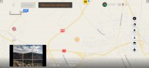
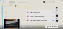
Some time ago I came across some facebook groups where people were using an iOS modded app that was supposed to not only enable FCC mode but also turn on ADS-B for newer Air 2 models that have the correct hardware. I eventually decided to try it out myself and what do ya know.... it actually works!
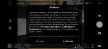
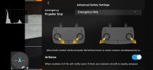
IMG_2843.jpeg IMG_2842.jpeg

IMG_2841.jpeg adsb_poianaBV.jpeg
 
  • Like
Reactions: rp6 and waffles985
Can you provide the gist of the method?
I don't use facebook etc. but wouldn't mind knowing how to mod the app.
Also is the mod specific to any app version e.g. 1.1.3, 1.1.6 etc.?
Thanks
 
Looks cool, did it work for FCC mode? Any more info ?

Yes, FCC mode works as well. I think the developer has an account here as well but he’s not active, give me a few minutes to dig for an old email.
 
Last edited:
Can you provide the gist of the method?
I don't use facebook etc. but wouldn't mind knowing how to mod the app.
Also is the mod specific to any app version e.g. 1.1.3, 1.1.6 etc.?
Thanks

It’s a modified version of the Fly app, which he keeps up to date. So he’s now at 1.2.5.
 
Some time ago I came across some facebook groups where people were using an iOS modded app that was supposed to not only enable FCC mode but also turn on ADS-B for newer Air 2 models that have the correct hardware. I eventually decided to try it out myself and what do ya know.... it actually works!
View attachment 124528 View attachment 124529

View attachment 124530 View attachment 124531

Pretty cool. In America, Air Sense only tells me (from what I've seen so far) that a manned aircraft is nearby - but that can be 1 mile away or less. Would be nice to have something tell me how close it truly is. We do sometimes have very low flying personal aircraft flying in my area and when it starts squawking, I'm looking around to find the plane. Sometimes can see them and sometimes not.
 
Pretty cool. In America, Air Sense only tells me (from what I've seen so far) that a manned aircraft is nearby - but that can be 1 mile away or less. Would be nice to have something tell me how close it truly is. We do sometimes have very low flying personal aircraft flying in my area and when it starts squawking, I'm looking around to find the plane. Sometimes can see them and sometimes not.

You can get a sense of how close it is by looking on the map, there’s also the scale in the top left corner
 
Hey all, a quick update on this. I contacted the dev and can confirm that have got FCC mode working on the Mini 2 in Europe. The app is pretty much identical to the stock DJI Fly app but boots into FCC mode.

thanks to Ice_2k for the connection ?
 
Last edited:
Hey all, a quick update on this. I contacted the dev and can confirm that have got FCC mode working on the Mini 2 in Europe. The app is pretty much identical to the stock DJI Fly app but boots into FCC mode.

thanks to Ice_2k for the connection [emoji4]

You moved fast :)
 
You can get a sense of how close it is by looking on the map, there’s also the scale in the top left corner

When I'm flying, it's hard enough to try and keep some kind of VLOS / see the drone and then watch a small screen to see what I'm doing drone wise to pull up the map or look at tiny icons on the screen. Since I don't try and fly around flight paths and keep it under 400ft AGL - then I have less worries about "where" the aircraft is as THEY should be higher than 400ft AGL in mountains. Now, helicopters are a bit different and we have them fly treetop level when working for the electric companies and out chopping trees with hanging saws from the chopper. But, when they are up I keep a very good eye on them and stay as far away as possible. Have only encountered them for 2 days in last couple of years, so they don't come around my usual flight zone (around my home) often. You can also hear them very well too.
 
When I'm flying, it's hard enough to try and keep some kind of VLOS / see the drone and then watch a small screen to see what I'm doing drone wise to pull up the map or look at tiny icons on the screen. Since I don't try and fly around flight paths and keep it under 400ft AGL - then I have less worries about "where" the aircraft is as THEY should be higher than 400ft AGL in mountains. Now, helicopters are a bit different and we have them fly treetop level when working for the electric companies and out chopping trees with hanging saws from the chopper. But, when they are up I keep a very good eye on them and stay as far away as possible. Have only encountered them for 2 days in last couple of years, so they don't come around my usual flight zone (around my home) often. You can also hear them very well too.
Fair enough, it would be beneficial to also display exactly how far it is. What would be even better is if they would show the altitude of the plane, the ADS-B transmission contains that information... Main issue is probably the drone not knowing it's own precise altitude and not wanting to confuse the user
 
Lycus Tech Mavic Air 3 Case

DJI Drone Deals

New Threads

Forum statistics

Threads
131,002
Messages
1,558,769
Members
159,985
Latest member
kclarke2929