Hi All,
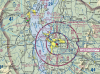
When I look at distances on a boating app and compare it to Google map and also to the DJI Go 4 app-they each tell me differently what airspaces are there. For instance, my own property is 15 miles from the nearest airport, nowhere near a stadium, heli pad, military base etc etc. But on Go 4 it says i'm located in about 5 different classes of airspace. What am I configuring wrong-something on the app? I do know that my boating app (Navionics) tells me in nm (based on gps as well) where things are-and I can honestly say in my experience from boat navigation that it is pretty darn close when judging between the paper chart and the app (locations of ATONs, obstacle to navigation etc)....as well as measuring in nautical miles and then comparing it to the App. I'm so confused trying to determine where in the future I can actually use this thing. Thanks
When I look at distances on a boating app and compare it to Google map and also to the DJI Go 4 app-they each tell me differently what airspaces are there. For instance, my own property is 15 miles from the nearest airport, nowhere near a stadium, heli pad, military base etc etc. But on Go 4 it says i'm located in about 5 different classes of airspace. What am I configuring wrong-something on the app? I do know that my boating app (Navionics) tells me in nm (based on gps as well) where things are-and I can honestly say in my experience from boat navigation that it is pretty darn close when judging between the paper chart and the app (locations of ATONs, obstacle to navigation etc)....as well as measuring in nautical miles and then comparing it to the App. I'm so confused trying to determine where in the future I can actually use this thing. Thanks