DJI Mavic, Air and Mini Drones
Friendly, Helpful & Knowledgeable Community
Join Us Now

Auto RTH + Forward Collision Avoidance Saved my Fanny Today

eEridani

Well-Known Member
Joined
Aug 21, 2021
Messages
1,269
Reactions
929
Location
ID, USA
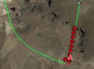
So out flying, was exploring a hill that was taller than I wanted to climb, but accessible if needed, and as I was drifting around the hill I found an interesting pillar to film. I neglected to recall that RF sometimes drops when an object gets between the two radios involved. Actually, I knew it was possible, but didn't really expect it to happen here. So - my first mistake was having the audio all off. I did feel the haptic warning, but the red signal warning on the display is small and invisible to me, so I didn't see what the issue was. Hindsight shows it was a weak signal warning. The next warning was lost signal - that was obvious enough it was hard to miss. Then came the dreaded RTH notice. I was a bit frantic. My RTH altitude was set to 180, and I was on top a hill that was several hundred feet above my takeoff altitude. Rereading the manual, 11 seconds. It didn't seem that long.

So, here comes the interesting part - according to RTH protocol, the drone goes to RTH Altitude: 180. But I was flying over a hill that was 600 feet higher than the takeoff point. In theory, the drone should have descended to 180' - well into the ground. I was remembering the manual mentioning RTH Autolanding when it gets near the ground and was thinking I was going to have to hike up and recover the drone. Argh. The drone did descend, but the obstacle avoidance was set to Bypass, and it saw the ground approaching and avoided it by maintaining altitude until it could descend. Once the drone was adequately in front of the pillar, I had control again.

The entire event took about 30 seconds, but taught me a few things about the Mavic Air 2 that reinforced my instinct I needed obstacle avoidance and made me quite happy I did not buy the Mini 2. lol. And no, the back side of the rock was not that interesting, after all.
 
If you are below your RTH altitude, it will climb to your set height before returning. If you are above your RTH altitude, it will maintain & return at your current height. It will NOT descend to your RTH setting. The obstacle avoidance you experienced was it flying around the hill you had flown behind, as it otherwise would have flown into the hill, not descended into the ground.
 
If you are below your RTH altitude, it will climb to your set height before returning. If you are above your RTH altitude, it will maintain & return at your current height. It will NOT descend to your RTH setting. The obstacle avoidance you experienced was it flying around the hill you had flown behind, as it otherwise would have flown into the hill, not descended into the ground.
Not true - my flight log shows the drone descending from altitude as it is returning home.

5m 16.5s P-GPS 18satellites 624.3ft N/A 24.9mph --- Weak signal. Make sure the remote controller is facing aircraft and avoid blocking the signal(Code 80016).; --- Weak signal. Adjust antennas.; 5m 30.4s Go Home 18satellites 624.7ft N/A 3.5mph ... Downlink Lost. - 15 seconds later ... it has obviously lost altitude as it is returning 5m 45.0s Go Home 18satellites 565.6ft N/A 23.0mph ... - here's the transition from RTH to P-GPS - shows it had gained 60' above where it lost the radio 6m 1.5s Go Home 18satellites 682.4ft N/A 22.5mph ... 6m 1.6s P-GPS 18satellites 682.7ft N/A 22.5mph ...

I've attached an image of the RTH portion of the flight... the drone turned directly to me, then started descending, until it could no longer descend, then up and over the hill. All in a straight line. My RTH Altitude was set at 180'.
 

Attachments

  • RTH.JPG
    RTH.JPG
    31.8 KB · Views: 22
Last edited:
...The drone did descend, but the obstacle avoidance was set to Bypass, and it saw the ground approaching...

...If you are above your RTH altitude, it will maintain & return at your current height. It will NOT descend to your RTH setting...

Not true - my flight log shows the drone descending from altitude as it is returning home...

@eEridani ... think you should study the user manual a bit more regarding the different RTH behaviors, not knowing how the craft will react in different situations can be fatal. You can download the full 53 page manual here --> https://dl.djicdn.com/downloads/Mavic_Air_2/Mavic_Air_2_User_Manual_v1.6_enIII.pdf (read page 12-15 for all about RTH)

First, you have below feature not mentioned so far. If the craft enters failsafe RTH it will backtrack ...

1631263801891.png

Secondly you have this function that possibly can be the reason ...when you say it was descending on the way back ...

1631264190314.png
 
Lecture all you want; read the log of what really happened.

Battery was at 75%, I doubt Power Save RTH was happening, during the 30 seconds the drone was out of contact, it couldn't have received any commands like 'Use Power Save' ... but that would explain the descent. Maybe it default is PS when the controller is silent. Also, I do not recall reading every word on screen when this was all happening - drone disconnected was the salient part of the message: I do not recall tapping any prompts - it was small red text, nearly invisible in full sun. I did hit the RTH button a few times during the panic, pretty sure the drone didn't hear my screaming. I really didn't want to hike up a dusty trail with a 600' elevation gain in 90 degree weather in street shoes. Then, all of a sudden the drone began responding. Panic over.

As an FYI, I have read the manual more than a few times, even watched a few PilotInstitute & other videos on how RTH works. None cover this scenario in detail.

ps: The flight does meet the Power Save RTH conditions. So yeah, that explains the attempted suicide dive into terrain.
 
Last edited:
  • Like
Reactions: hiflyer201
Lecture all you want...
As an FYI, I have read the manual more than a few times...
Looks like you have a bit of a attitude towards members trying to help ... you will not get far with that I'm afraid.

...read the log of what really happened
Where is it ..? The only thing you have shared so far is pics that doesn't say anything ...

Battery was at 75%, I doubt Power Save RTH was happening...
Power save RTH have absolutely nothing to do with the battery percentage ...
 
1) Looks like you have a bit of a attitude towards members trying to help ... you will not get far with that I'm afraid.


2) Where is it ..? The only thing you have shared so far is pics that doesn't say anything ...


3) Power save RTH have absolutely nothing to do with the battery percentage ...
#1 - lol - you're the one being sensitive. A post that begins with RTFM also isn't helpful.

#2 - See my post #3, above -- the full .dat isn't needed to understand what happened; and the point of my post was to say the BYPASS collision avoidance saved the day. I wasn't asking for an analysis, I already did that; so again, no .dat needed: a few timestamped records shows the pertinent details in reply to Guy's post.

#3 - Probably not - but trying to divine what the DJI engineers were thinking when they named the RTH mode POWER SAVE it is easy to envision battery power is part of it. The entire intent appears to use a glidepath to reduce power consumption during RTH, hence, the battery level is or seems likely to be part of their thinking. I'm not them, I also didn't design the code, so why the name is what it is is only a guess.

As for the manuals to be the end all, I have a couple requests for information over at DJI - for example the DJI Fly app UI has some Chinese in it related to audio controls. But finding information in documents is a chore. I have nine separate DJI manuals that I am referring back to daily. It took several passes through the set before I realized the missing DJI Fly app manual is partially contained in the DJI Mavic Air 2 User Guide ... though the DJI Fly app info is cursory at best, and is missing at least one key control icon.

And to be clear - I'm not arguing with you. At least that is not my intention.
 
In theory, the drone should have descended to 180'
From where do you get that idea? Whilst I do not have an Air 2 I do have several models of DJI drone, If they are above the RTH height and RTH'd none of them has shown any tendency descend to the RTH height.

Are you suggesting that this "bypass" function moniters ground clearance? If so from where do you get that idea?
The impression I got/get (from youtubes) was that it was looking out for things at its height i.e. level with it, and in its flight path. Yes, I did get the impression that in some instances it will fly around an obstacle and in other instances it will climb to pass over the obstacle but I did not get the impression that "bypass" is monitoring the actual ground clearance.

You make reference to the log yet, that I can see, do not provide it.
It might be useful to everyone if you did provide it or a link to it.
It might correct misunderstandings, who ever has them.
I am always open to being corrected as it may one day save my drone, I am sure your other respondants have the same sentiment.

With regards to the snippet of data that you do provide, is it possible that immediately prior to the loss of connection you had commanded the drone to climb?
From a recent experimental RTH with a Mini 2 I am left wondering if, during the 50m reverse, the drone reverses along the original flight path in three dimensions, it makes sense for it to do that but I have yet to confirm it by experiment.
Thus, if you had made the drone climb in the 50m prior to loss of contact and if the reverse retraces the flight path in 3D, the drone would descend.
 
Last edited by a moderator:
Not true -
Lecture all you want
you're the one being sensitive.
I wasn't asking for an analysis, I already did that
If that's not 'attitude', I don't know what is...

And if you're convinced your analysis of the log is true and complete, and had rather not take slup on his offer to give you an expert analysis, so be it... no matter what really happened, you'll never know the truth.
 
Awesome, thanks for sharing!
 
From where do you get that idea? Whilst I do not have an Air 2 I do have several models of DJI drone, If they are above the RTH height and RTH'd none of them has shown any tendency descend to the RTH height.

Are you suggesting that this "bypass" function moniters ground clearance? If so from where do you get that idea?
The impression I got/get (from youtubes) was that it was looking out for things at its height i.e. level with it, and in its flight path. Yes, I did get the impression that in some instances it will fly around an obstacle and in other instances it will climb to pass over the obstacle but I did not get the impression that "bypass" is monitoring the actual ground clearance.

You make reference to the log yet, that I can see, do not provide it.
It might be useful to everyone if you did provide it or a link to it.
It might correct misunderstandings, who ever has them.
I am always open to being corrected as it may one day save my drone, I am sure your other respondants have the same sentiment.

With regards to the snippet of data that you do provide, is it possible that immediately prior to the loss of connection you had commanded the drone to climb?
From a recent experimental RTH with a Mini 2 I am left wondering if, during the 50m reverse, the drone reverses along the original flight path in three dimensions, it makes sense for it to do that but I have yet to confirm it by experiment.
Thus, if you had made the drone climb in the 50m prior to loss of contact and if the reverse retraces the flight path in 3D, the drone would descend.

Before I go on here - I want to make it perfectly clear I am not trying to be an affront to anyone nor proffer some attitude. If I am coming across that way it is the text medium and my writing style interfering.

My reason for saying the RTH function flew the drone in a descent is in the data I took off the drone. Nothing to imagine or infer. The data log shows a descent. I can't help it if you don't believe me - have a look at the data snips.

My reason for saying the RTH function flew the drone in an ascent is in the data I took off the drone. Nothing to imagine or infer. The data log shows an ascent instead of collision (and the drone made it back, which is further evidence the drone dealt with the terrain it faced). Again, I can't help it if you don't believe me - the data is the data.

You say I didn't post the log. I did, just not the full 100% multi-meg file that would waste everyone's time. I am NOT looking for analysis. I did post (in my post #3 above) the salient records from the flight that show what happened.

And no - I did not tell the drone to climb before LOS. If I did that, why did it begin descending almost immediately after LOS and starting RTH.

Besides the data it hints the drone stops, then retraces. The mapped log snip - also in post #3 - shows what I think to be the 50m reversal - the short red tick in the flight path left/right. The drone was in slow more or less level flight at the time LOS occurred.

====

The bottom line is that there is no mystery in my mind what the drone did, the log is quite clear.

====

The only mystery is why the LOS; all I can think of is while flying behind the rock and the drone becoming visible again I was watching for it to come out and inadvertently turned the controller off-axis enough antenna aim was compromised.

A deeper dive into the data shows the elevator was in a steady UP bias (1684) but not ascending when the RTH kicked in, then the elevator position changed significantly, back to what I guess is mid-range (1024). Now I'm thinking the drone might have hit a downdraught as it flew behind the rock and the RC (or drone) was compensating for it (but not enough, lol). I started the maneuver at 700' and it ended at 625' - and I wasn't intentionally trying to lose altitude. The air wasn't especially turbulent - but was unstable.

ps: and to be clear, I was about 100' agl the entire flight.
 
Last edited:
You say I didn't post the log. I did,
You didn't post the log, just a picture of a part of it.
multi-meg file that would waste everyone's time. I am NOT looking for analysis.
The .txt log on your flight device is not that large. You don't want an analysis?... fine. Your interpretation of events is doing no one any good though, including you.
 
You didn't post the log, just a picture of a part of it.

The .txt log on your flight device is not that large. You don't want an analysis?... fine. Your interpretation of events is doing no one any good though, including you.
True enough. My initial post was to compliment the drone for flying out of an otherwise bad situation, 100% entirely on it's own. No where in that post did I even hint I desired an explanation.

Others took it upon themselves to say what happened couldn't have happened. It's a bit funny people are arguing that what did happen didn't or could not have happened, as if the drone should have crashed. I mean - what's to argue - the drone was lost but flew to where it wasn't lost. And I guess single records from the log aren't enough to satisfy simple questions asked by others.

At the end of the day this entire off-topic sub-dialog pointed out something that might have happened, the 75' descent I can't explain right now, though I'll eventually dig into that deep enough I can better understand the events leading up to it and the LOS (beyond the 'I flew behind a rock' part). The altitude loss may have been my finger; it may have been the atmosphere (there was clear air virga near me). Bottom line - as the NTSB would say - pilot error was involved - end of story.
 
I did not tell the drone to climb before LOS. If I did that, why did it begin descending almost immediately after LOS and starting RTH.
It reverses along the last 50m of the flight path.
If it literally follows the original flight path during the reverse then your ascent on the outward leg of the journey becomes a descent on the return leg of the journey.

I suggest you try an experiment, just as I am going to do with my Mini 2.

With the drone in clear sight have it climb to a height below the RTH height and let it sit there of a minute or so, just to establish a clear distinction between various sections of the flight. Then make the drone climb, vertically, to say 100ft above the RTH height, then move 15m across your field of view (so that the movement is visible), then descend, vertically, to say 50ft below the RTH height. Then move another 15m across you field of view, then climb, vertically, to RTH height plus 100ft or so, then move another 15m across you field of view.
Then switch the controller off and watch what the drone does.

I would also suggest you try another set of experiments where you switch the controller off when the drone is in clear sight and above the RTH height. Providing you are not at distances and heights that could lead to a power saving RTH, take note of how many times the drone descends to the RTH height whilst moving towards the hoempoint.
 
Last edited by a moderator:
It reverses along the last 50m of the flight path.
If it literally follows the original flight path during the reverse then your ascent on the outward leg of the journey becomes a descent on the return leg of the journey.

I suggest you try an experiment, just as I am going to do with my Mini 2.

With the drone in clear sight have it climb to a height below the RTH height and let it sit there of a minute or so, just to establish a clear distinction between various sections of the flight. Then make the drone climb, vertically, to say 100ft above the RTH height, then move 15m across your field of view (so that the movement is visible), then descend, vertically, to say 50ft below the RTH height. Then move another 15m across you field of view, then climb, vertically, to RTH height plus 100ft or so, then move another 15m across you field of view.
Then switch the controller off and watch what the drone does.

I would also suggest you try another set of experiments where you switch the controller off when the drone is in clear sight and above the RTH height. Providing you are not at distances and heights that could lead to a power saving RTH, take note of how many times the drone descends to the RTH height whilst moving towards the hoempoint.

A bit deeper look at the control sticks during the LOS event, throttle position shows ~800 (0-2048 range, 1024 is hover), I was apparently in a controlled slow descent. Bad thumb control - aka pilot error - I had zero intention of losing altitude up there. I was trying to maintain a slow turn, but I must have had downward pressure on the stick. I was so intent on seeing the drone come out from behind the rock I messed up my control. The old pilot training comes to mind and I can hear Ron, my CFI saying - FLY THE AIRCRAFT! as he let loose his belt and climbed in front of me on final approach (yeah, hard to do in a Cessna, but he did it - lol).

The experiments sound like generally good advice and experience. I'll need to find a suitable flat field where landing is safe -- all the talk of dirt blown into the camera gimbal upon landing costing big bucks to repair worries me and I am hyper vigilant to land on my clean table mounted landing pad.

ps: Here's the flight plan vs what happened. It's the Power Save RTH vector where the drone was also descending, but the BYPASS mode overrode it and kept the drone from crashing. The slopes involved are steep, and likely played a role. The BYPASS feature may not help with level ground.
 
Last edited:
Maybe I am being thick but the illustration you provide merely confuses me, what are the two, 1/2 mile long, black lines? They can not both be outward bound flight paths.

You would make it much easier for folks to understand your flight if you provided the full flight log, not snippets of it. From the cut-and-pastes and images you have added I would guess the log has already been uploaded to the likes of Phantomhelp or Airdata so why not provide the link.
You have nothing to lose by providing the information and possibly much to gain.
Until that data is provided and understood all anyone can do, yourself included, is venture opinions i.e. "....d are steep, and likely played a role."

The likes of Slup and some others are superb at reading logs and pulling together bits and pieces from the logs that, to my mind at least, are seeming inconsequential details to create the full story of what happened and explain it.
You are penalising yourself by not taking advantage of their generousity.
 
You have nothing to lose by providing the information and possibly much to gain.
I'm thinking there's some aspect of this flight the OP does not want to publish. Maybe it's vlos, maybe it's altitude related?

Whatever it is, I'm not interested anymore... and if he doesn't want an expert analysis, I wonder why he even started this thread to begin with? Maybe to show off the fact that he can read a log, and make maps?

And if you'll notice, you and I are the only ones still commenting... everyone else has flew the coop.

Unwatching
 
Maybe I am being thick but the illustration you provide merely confuses me, what are the two, 1/2 mile long, black lines? They can not both be outward bound flight paths.

You would make it much easier for folks to understand your flight if you provided the full flight log, not snippets of it. From the cut-and-pastes and images you have added I would guess the log has already been uploaded to the likes of Phantomhelp or Airdata so why not provide the link.
You have nothing to lose by providing the information and possibly much to gain.
Until that data is provided and understood all anyone can do, yourself included, is venture opinions i.e. "....d are steep, and likely played a role."

The likes of Slup and some others are superb at reading logs and pulling together bits and pieces from the logs that, to my mind at least, are seeming inconsequential details to create the full story of what happened and explain it.
You are penalising yourself by not taking advantage of their generousity.

Back to that "I was never asking for help" aspect of my initial post.

Philius - while I do appreciate the sentiment - as for what will I gain? Nothing. I know what happened - the drone was lower in elevation than I expected, it went behind an RF blocking obstacle long enough the RC lost connection with the Drone. No mysteries: just an accidental unintended consequence of a fat thumb.

I'll go back and remove the confusing drawings that seems to cause more questions than answers. They were my interpretations of the log data - but applied to topo maps rather than unhelpful sat images - and had my flight planning attached (those black lines were my plan for the flight made ahead of time).

If I did supply more info all I would have gotten is more bashing for a post that was intended to be a "Wow - look what my drone did!" compliment for the DJI Mavic Air 2. So I'll say Mea Culpa one more time and walk away from the discussion myself; and will try my best to not to post such things again.
My only issue in post #2 above was refuting your original assumption that the drone should have immediately descended to your RTH altitude when it lost signal, when you were already above it.

"So, here comes the interesting part - according to RTH protocol, the drone goes to RTH Altitude: 180. But I was flying over a hill that was 600 feet higher than the takeoff point. In theory, the drone should have descended to 180' - well into the ground..
 
@GadgetGuy

My reaction was to the "The obstacle avoidance you experienced was it flying around the hill you had flown behind, as it otherwise would have flown into the hill, not descended into the ground."

Yes, bypass can go sideways, but all of the text flight data (and user manuals confirm) indicate vertical avoidance during RTH. And going around wasn't an option in any case: the hill the drone faced was much too large to go around. I really buried the drone in a valley. See photos below.

What we can surmise is the drone entered Straight Line RTH, determined it was within the Power Save parameters, and began the 16 degree gliding descent. Straight Line might have and Power Save did drive the drone into the slope - then some other system intervened. The video makes it very clear the drone was well below the crest it was approaching. So OA is the only system I know of, it was set to BYPASS.

The only thing that is unknown, and that the .txt file won't tell anyone, is whether or not the forward vision system detected the hill face, or if the vertical sensors saw the ground and the math didn't add up so the drone ascended. My vote is for the forward vision system interceding.

The video shows the drone react to the hill face by smoothly changing from descent to ascent until it was well clear of the crest, then flying straight and perhaps beginning to descend again. But I regained control at that point so exactly what was happening next is unclear.


Tried attaching images, the forum isn't letting me. If an image does show up, it's where the drone ended its descent and started ascending to pass over the hill. It was traveling 25MPH the entire time.


Minutes before I had flown over this hill a couple of times without incident, so the fact I swooped low on that last pass bugs me to no end. Had it been a non-hikeable area, or the OA mode had slipped to BRAKE like it is very prone to do, I'd very likely have lost the drone.

But then, I'd chosen this spot because it is a hikeable area, and I try to ensure OA is always set to BYPASS, I really do not want to lose a thousand dollar part due to negligence. That's why I am at a loss for how I did the heavy thumb thing.
 

Attachments

  • vlcsnap-2021-09-13-22h13m26s688.jpg
    vlcsnap-2021-09-13-22h13m26s688.jpg
    304.3 KB · Views: 5
Last edited:
Lycus Tech Mavic Air 3 Case

DJI Drone Deals

New Threads

Members online

Forum statistics

Threads
130,978
Messages
1,558,530
Members
159,967
Latest member
rapidair