DJI Mavic, Air and Mini Drones
Friendly, Helpful & Knowledgeable Community
Join Us Now

B4U Fly App and wilderness areas

clandherr

Member
Joined
Aug 22, 2022
Messages
6
Reactions
2
Age
41
Location
Denver, CO, USA
I am new to having a drone. I do a lot of camping and I am looking to get some cool photos and videos as a hobby. I am confused about the maps on Aloft and B4U Fly in the mountains in CO. The section of MAP attached shows wilderness area around some white area. When I click on the white area, which is where I will be, I get a clear for takeoff. However, listed below it says FS Wilderness Area. I am confused, am I good to fly or not? The wilderness area warning has a mileage distance and I believe it might just be giving me a warning that wilderness area is within 2.07?? Aloft shows it as very similar. I get a green symbol with an exclamation point with the same wilderness area notification.

Can anyone help me understand what this means?
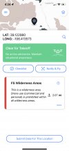
1567ABF1-0092-4C8A-90D0-F999C6C4F4B1.jpeg
 
Is that federal land? National Park land?

What is USFS wilderness area?


The National Wilderness Preservation System is a network of over 111.7 million acres – more area than the state of California - of public land comprised of more than 803 wilderness areas administered for the American people by the federal government. These are special places where nature still calls the shots.

That last sentence says it all.
 
Last edited:
Is that federal land? National Park land?

What is USFS wilderness area?


The National Wilderness Preservation System is a network of over 111.7 million acres – more area than the state of California - of public land comprised of more than 803 wilderness areas administered for the American people by the federal government. These are special places where nature still calls the shots.
so it‘s in the Pike-San Isabel national forest, but this particular area is not marked as wilderness area.
 
  • Like
Reactions: Bob in Savannah
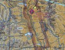
Most likely that is the distance to the nearest part of the wilderness areas surrounding your marker on the B4UFly map. Everything in brown on that map is indeed wilderness on the FAA sectional charts and are no fly areas. At least on the sectional charts what is shown in white on your map are legitimate areas to fly in Class G airspace up to 400' above ground level.Leadville.jpg

Everything inside of the solid blue lines with the dots on the inside is wilderness.
 
  • Like
Reactions: Bob in Savannah
Most likely that is the distance to the nearest part of the wilderness areas surrounding your marker on the B4UFly map. Everything in brown on that map is indeed wilderness on the FAA sectional charts and are no fly areas. At least on the sectional charts what is shown in white on your map are legitimate areas to fly in Class G airspace up to 400' above ground level.View attachment 153735

Everything inside of the solid blue lines with the dots on the inside is wilderness.
Great job with this map! I see Leadville which I hiked right thru on the CDT in 1993! Mex->Can '93

Great memories!
 
Most likely that is the distance to the nearest part of the wilderness areas surrounding your marker on the B4UFly map. Everything in brown on that map is indeed wilderness on the FAA sectional charts and are no fly areas. At least on the sectional charts what is shown in white on your map are legitimate areas to fly in Class G airspace up to 400' above ground level.View attachment 153735

Everything inside of the solid blue lines with the dots on the inside is wilderness.
so what is the result, fly or not?
 
As others have said, no flying from Designated Wilderness. You can fly over it, but for what reason? You have to maintain all FAA regulations, so there is really no point. You couldn't fly into it very far. And people go to Wilderness areas to get away from it all.

Also, I see you're from Denver. I'm in Lakewood. Look up Denver Drone Pilot Social Hour on Facebook. We meet the last Tuesday each month in Golden. We meet to fly, talk about drones, and partake in an adult beverage or two. After we fly of course.
 
  • Like
Reactions: 13_Dragons
Wilderness areas can be a real source of confusion. I saw this on a recent trip to the White Mountains in New Hampshire.
We all know that National Parks (not to mention airports, military bases and such) are off limits. Many of us know that National Forests are generally not, but they can be IF they're also a Wilderness area, or a national trail like the Appalachian Trail.
 
As others have said, no flying from Designated Wilderness. You can fly over it, but for what reason? You have to maintain all FAA regulations, so there is really no point. You couldn't fly into it very far. And people go to Wilderness areas to get away from it all.

Also, I see you're from Denver. I'm in Lakewood. Look up Denver Drone Pilot Social Hour on Facebook. We meet the last Tuesday each month in Golden. We meet to fly, talk about drones, and partake in an adult beverage or two. After we fly of course.
I don’t want to fly over or in Wilderness area. I plan on hiking Mt. Elbert and according to the maps it is NOT a wilderness area and B4U fly says it is good for take off. Was hoping to get some cool shots on the top of the 14er and just double checking it was OK to fly there. Thanks for the invite to the social hour. I don’t have a facebook account. What time do you normally meet up?
 
Lycus Tech Mavic Air 3 Case

DJI Drone Deals

New Threads

Forum statistics

Threads
130,985
Messages
1,558,562
Members
159,973
Latest member
flyingthe405