

I am puzzled by the difference between B4UFLY and DJI's flysafe. B4UFLY lights up zones that it says require permission that the DJI web site does not. I don't use B4UFLY simply because I got used to the DJI site before I even knew B4UFLY existed. My experience is very local and the DJI app has allowed me to get permission to fly in the few places that I have needed but I am going on a trip to the lower 48 and wonder if the DJI web site is sufficient for getting permissions, ie if I was in a zone that the B4UFLY app claimed I needed LAANC permission but the DJI did not have that as restricted, would my drone take off and allow me to fly? Thoughts?

You are using an out of date browser. It may not display this or other websites correctly.
You should upgrade or use an alternative browser.
You should upgrade or use an alternative browser.
B4UFLY vs DJI flysafe
- Thread starter akdrone
- Start date
Skwirl
Well-Known Member
As was explained to me in another thread a while back.
B4ufly is the FAA app to use and follow.
The dji fly app is their own attempt at being our nanny. The fly app has areas restricted, that you need to unlock thru dji. They may or may not actually be restricted.
So even though b4ufly says good to go, the dji nanny app may lock you out. And you need to get an approval thru dji to unlock that area.
vindibona1
Well-Known Member
- Joined
- Jun 21, 2020
- Messages
- 3,977
- Reactions
- 3,962
I could be wrong and things may have changed, but it's kind of lobotomized. Flysafe is essentially a warning system that you are near/in a NFZ or Restricted area. If so, you have to apply to have geofencing unlocked via the Flysafe cite. HOWEVER, in many cases you need to get ATC authorization to provide documentation to Flysafew during the unlock process. So you have have to use B4UFly or Aloft to get ATC authorization then go back to DJI for unlocking. It's a clumsy procedure.
Also, DJI maps often show flight paths that have nothing to do with the airspace and altitude limitations. I only have one real gripe about DJI- and that's their over-aggressive geofencing
Also, DJI maps often show flight paths that have nothing to do with the airspace and altitude limitations. I only have one real gripe about DJI- and that's their over-aggressive geofencing
manutter51
Member
Fly Safe tells you whether DJI thinks you're ok to fly there, and B4UFly tells you whether the FAA thinks you're ok to fly there. If Fly Safe says "OK," and B4UFly says "Not OK," you may be liable for significant penalties if you choose to fly and anything goes wrong. Or at least, that's my understanding. I'm still learning the ins and outs.
brett8883
Well-Known Member
It’s really important to understand that the DJI system is a completely different system and has nothing to do with what is legal or not as far as the government is concerned. You have to look at B4Ufly or better yet Aloft before every flight. It’s also important to understand that DJI cannot give you FAA permission to fly in controlled airspace, you have to go through a LAANC provider such as Aloft for that.I am puzzled by the difference between B4UFLY and DJI's flysafe. B4UFLY lights up zones that it says require permission that the DJI web site does not. I don't use B4UFLY simply because I got used to the DJI site before I even knew B4UFLY existed. My experience is very local and the DJI app has allowed me to get permission to fly in the few places that I have needed but I am going on a trip to the lower 48 and wonder if the DJI web site is sufficient for getting permissions, ie if I was in a zone that the B4UFLY app claimed I needed LAANC permission but the DJI did not have that as restricted, would my drone take off and allow me to fly? Thoughts?
You are correct that DJI’s system is much more permissive than the FAAs so when DJI required you to get unlocks from them and you did not get authorization from the FAA as well, in all likelihood you were flying illegally in the eyes of the government in those cases. You are lucky you came to us with this question before you got in trouble for it.
Faster
Well-Known Member
It’s really important to understand that the DJI system is a completely different system and has nothing to do with what is legal or not as far as the government is concerned. You have to look at B4Ufly or better yet Aloft before every flight. It’s also important to understand that DJI cannot give you FAA permission to fly in controlled airspace, you have to go through a LAANC provider such as Aloft for that.
You are correct that DJI’s system is much more permissive than the FAAs so when DJI required you to get unlocks from them and you did not get authorization from the FAA as well, in all likelihood you were flying illegally in the eyes of the government in those cases. You are lucky you came to us with this question before you got in trouble for it.
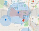
In my case is all of the contrary, DJI is WAY more restrictive than FAA.


Attachments
Last edited:
brett8883
Well-Known Member
Looks about the same to me, there’s a couple of non-towered airports DJI has on there but If you zoom out a little you’ll see DJI missed a large prohibited Military base to the south… whoopsIn my case is all of the contrary, DJI is WAY more restrictive than FAA.
View attachment 145887
View attachment 145886


Faster
Well-Known Member
Yep big error from DJI for not counting Homestead Air Base as a Military Base, LOL huge mistake. but at the same time they are counting two small airports as Level Auth Zones that FAA doesn't have.Looks about the same to me, there’s a couple of non-towered airports DJI has on there but If you zoom out a little you’ll see DJI missed a large prohibited Military base to the south… whoops
View attachment 145891
View attachment 145890
brett8883
Well-Known Member
DJI does have geozones around non-towered airports which does go to show you that the systems are completely different which drives home the point that you cannot rely on DJI to figure out where it is legal to fly.Yep big error from DJI for not counting Homestead Air Base as a Military Base, LOL huge mistake. but at the same time they are counting two small airports as Level Auth Zones that FAA doesn't have.
FLDave
Well-Known Member
DJI may be more informative with it's color graphics; and that is really nice. In my Leesburg, FL case the FlySafe app doesn't even show the 5 mile radius from the controlled airport. More informative means the pilot has a lot more information available on which to make a safe and correct decision to fly or not fly. It means the pilot needs to really understand the flight rules around airports and controlled airspace. This app cannot give you permission to fly into controlled airspace. It's nice to see approach and departure lanes listed and that can be informative to know why so many manned aircraft are flying overhead.
B4UFLY gives very specific areas of controlled and restricted airspace to know where you can legally fly or not fly or need FAA permission to fly.
So, the systems are different but both important for the pilot to analyze all details to make a safe decision. It's not that one is better than the other. In the end it is the pilot in command who needs to understand the national airspace system (controlled and not) in order to fly safely.
Let me see if I can get this right.
1. B4UFly app is an FAA app. It informs you and does so with greater detail.
2. Just because you have DJI’s permission (and thus ability to launch) you may not have FAA authorization.
3. You might learn it is all clear to fly from B4UFly but still be unable to take off because DJI thinks it’s an ares that requires permission.Your drone can be locked out from flying if DJI thinks the area is a special zone even if B4UFly thinks otherwise.
4. Apparently B4UFly refers you to the program Aloft in order to get actual FAA permission to fly and THEN…you may have to still get permission from the DJI website to unlock your drone’s ability to actually fly.
Is that all correct? If so I would ask " When you are in an authorization zone does everyone here first use Aloft to get a LAANC permission (is that the correct terminology?) and then go to the DJI website to get DJI to unlock the drone?
I opened the Aloft app and found it quite confusing. It seems to list a local University area regardless of how far I am looking which seems meaningless because it's not restricted and how to actually get a LAANC approval via the apps is really quite confusing but I'll do some web searching on that end. I think there are other apps that can also give me FAA approval. "They" don't make this easy and I'm a reasonably techno-savvy kind of guy. I can understand how many folks just throw up their hands and fly any old way they want regardless of the rules but I'll get this figured out and appreciate everyone's help") .
.
1. B4UFly app is an FAA app. It informs you and does so with greater detail.
2. Just because you have DJI’s permission (and thus ability to launch) you may not have FAA authorization.
3. You might learn it is all clear to fly from B4UFly but still be unable to take off because DJI thinks it’s an ares that requires permission.Your drone can be locked out from flying if DJI thinks the area is a special zone even if B4UFly thinks otherwise.
4. Apparently B4UFly refers you to the program Aloft in order to get actual FAA permission to fly and THEN…you may have to still get permission from the DJI website to unlock your drone’s ability to actually fly.
Is that all correct? If so I would ask " When you are in an authorization zone does everyone here first use Aloft to get a LAANC permission (is that the correct terminology?) and then go to the DJI website to get DJI to unlock the drone?
I opened the Aloft app and found it quite confusing. It seems to list a local University area regardless of how far I am looking which seems meaningless because it's not restricted and how to actually get a LAANC approval via the apps is really quite confusing but I'll do some web searching on that end. I think there are other apps that can also give me FAA approval. "They" don't make this easy and I'm a reasonably techno-savvy kind of guy. I can understand how many folks just throw up their hands and fly any old way they want regardless of the rules but I'll get this figured out and appreciate everyone's help
.Fly Safe tells you whether DJI thinks you're ok to fly there, and B4UFly tells you whether the FAA thinks you're ok to fly there. If Fly Safe says "OK," and B4UFly says "Not OK," you may be liable for significant penalties if you choose to fly and anything goes wrong. Or at least, that's my understanding. I'm still learning the ins and outs.
Fly Safe tells you whether DJI thinks you're ok to fly there, and B4UFly tells you whether the FAA thinks you're ok to fly there.
That's the most succinct and best explanation I've seen. It's right on target.
Let me see if I can get this right.
1. B4UFly app is an FAA app. It informs you and does so with greater detail.
2. Just because you have DJI’s permission (and thus ability to launch) you may not have FAA authorization.
3. You might learn it is all clear to fly from B4UFly but still be unable to take off because DJI thinks it’s an ares that requires permission.Your drone can be locked out from flying if DJI thinks the area is a special zone even if B4UFly thinks otherwise.
4. Apparently B4UFly refers you to the program Aloft in order to get actual FAA permission to fly and THEN…you may have to still get permission from the DJI website to unlock your drone’s ability to actually fly.
Is that all correct? If so I would ask " When you are in an authorization zone does everyone here first use Aloft to get a LAANC permission (is that the correct terminology?) and then go to the DJI website to get DJI to unlock the drone?
I opened the Aloft app and found it quite confusing. It seems to list a local University area regardless of how far I am looking which seems meaningless because it's not restricted and how to actually get a LAANC approval via the apps is really quite confusing but I'll do some web searching on that end. I think there are other apps that can also give me FAA approval. "They" don't make this easy and I'm a reasonably techno-savvy kind of guy. I can understand how many folks just throw up their hands and fly any old way they want regardless of the rules but I'll get this figured out and appreciate everyone's help
I'd add a couple of thoughts. In item 1) , B4YOUFLY shows the FAA regulations that govern drone operations. In 4) Aloft (and other programs) are used to get LAANC authorization to fly in the controlled airspace around the larger airports listed in the FAA's UAS Facility Maps. LAANC doesn't apply in all DJI authorization zones, just around airports.
I like @manutter51's explanation:
"Fly Safe tells you whether DJI thinks you're ok to fly there, and B4UFly tells you whether the FAA thinks you're ok to fly there."
Yep, even after you know that it's ok to fly in a certain area, you might still have to release DJI's lock on it.
LAANC seems very cryptic and confusing at first, but just wade in and try it out. You can go through the process without actually conducting a flight.
Skwirl
Well-Known Member
This reminds me of being a kid and asking mom to go swim in the creek and she said no, then asking dad and being told to be home for supper, lol.
Yes, but not quite. The FAA makes and enforces the rules. It's not an either/or situation. Having permission from DJI won't hold any water if you get into a violation problem with the FAA.This reminds me of being a kid and asking mom to go swim in the creek and she said no, then asking dad and being told to be home for supper, lol.
Skwirl
Well-Known Member
Timothy 1939
New Member
I am new to this. There is a Restricted that I live in. I though the M2 Zoom would pick that up when I took it up for the first time, but no problem. I was introduced to B4UFLY in this fornm and did not know Flysafe at the time/ I use UAF forcast for wind mph. Still learning.I could be wrong and things may have changed, but it's kind of lobotomized. Flysafe is essentially a warning system that you are near/in a NFZ or Restricted area. If so, you have to apply to have geofencing unlocked via the Flysafe cite. HOWEVER, in many cases you need to get ATC authorization to provide documentation to Flysafew during the unlock process. So you have have to use B4UFly or Aloft to get ATC authorization then go back to DJI for unlocking. It's a clumsy procedure.
Also, DJI maps often show flight paths that have nothing to do with the airspace and altitude limitations. I only have one real gripe about DJI- and that's their over-aggressive geofencing
brett8883
Well-Known Member
Yea that’s pretty much it. I would spend some time learning Aloft. I get what you mean by it shows you things that are outside the view you are looking at but I guess it is showing you all the things to be aware of that you could possibly encounter within the flight radius of the drone. It’s really just the colored circles and sometimes polygons on the map you have to worry about though. It’s pretty easy once you understand. I actually think DJI’s system is much more complicated but you already got that part down.Let me see if I can get this right.
1. B4UFly app is an FAA app. It informs you and does so with greater detail.
2. Just because you have DJI’s permission (and thus ability to launch) you may not have FAA authorization.
3. You might learn it is all clear to fly from B4UFly but still be unable to take off because DJI thinks it’s an ares that requires permission.Your drone can be locked out from flying if DJI thinks the area is a special zone even if B4UFly thinks otherwise.
4. Apparently B4UFly refers you to the program Aloft in order to get actual FAA permission to fly and THEN…you may have to still get permission from the DJI website to unlock your drone’s ability to actually fly.
Is that all correct? If so I would ask " When you are in an authorization zone does everyone here first use Aloft to get a LAANC permission (is that the correct terminology?) and then go to the DJI website to get DJI to unlock the drone?
I opened the Aloft app and found it quite confusing. It seems to list a local University area regardless of how far I am looking which seems meaningless because it's not restricted and how to actually get a LAANC approval via the apps is really quite confusing but I'll do some web searching on that end. I think there are other apps that can also give me FAA approval. "They" don't make this easy and I'm a reasonably techno-savvy kind of guy. I can understand how many folks just throw up their hands and fly any old way they want regardless of the rules but I'll get this figured out and appreciate everyone's help
FLDave
Well-Known Member
You can check out the web site: B4UFLY- The Leading Airspace & Situational Awareness Tool for Drone OperatorsI am new to this. There is a Restricted that I live in. I though the M2 Zoom would pick that up when I took it up for the first time, but no problem. I was introduced to B4UFLY in this fornm and did not know Flysafe at the time/ I use UAF forcast for wind mph. Still learning.
Brooksville shows a restricted around the Brooksville-Tampa regional airport. You can search specific area by address also. Just because there would be no restricted airspace you need to make sure your takeoff and landing areas or OK and you comply with all FAA rules.
For weather go to AWC - Aviation Weather Center
Similar threads
- Replies
- 10
- Views
- 1K
- Replies
- 9
- Views
- 1K
- Replies
- 3
- Views
- 672
- Replies
- 11
- Views
- 2K


DJI Drone Deals
1. Mini 2
2. Mini 3 Pro
3. Mini 4 Pro
4. Air 2s
5. Air 3
6. Avata 2
7. Mavic 3 Pro
8. Mavic 3 Classic
2. Mini 3 Pro
3. Mini 4 Pro
4. Air 2s
5. Air 3
6. Avata 2
7. Mavic 3 Pro
8. Mavic 3 Classic
New Threads
-

-

-
Air 3 Gandia ( Spain ) RH Hotel Study and Gandia Beach
- Started by Pacefast
- Replies: 0
-

-
Members online
Total: 841 (members: 12, guests: 829)
Forum statistics
