Preview
Hey Mavic Pilots - first post.
I flew RC planes in Iowa for many years as a kid (40 years ago) yikes. Had a few hundred hours or more back then and 10 years ago took it back up with more RC planes, but dropped it after a couple years. Been considering a drone for quite a while so I jumped in with Mavic Pro 8 weeks ago and been putting in bunches of flights. She's far better than I expected. Decided to get the sUAS FAA Part 107 Certification done, for several reasons so that's completed with passing score on the exam 3 weeks ago.
For for a first post I've found a tool I believe some of you may find valuable. If you have something that provides this better than this app, please let me know. Thanks!
The Situation
I'm living and flying in a very hilly area and is great for photos / video of desert scenery, wildlife. The constant question of: "how do I accurately judge from my take-off point altitude, if I am going up to an altitude high enough to clear hills in the distance?" Let alone the trees or power lines that may rise above these hills."
The Challenge
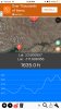
Take measurements of the point from which I will fly from, to the end point with measurements of the hills I will fly over, and determine the maximum hight of any hill to be cleared, in between.
My Solution Used (App)
So my search actually didn't take that long. Though I've not found posts about this or other apps on this site (there very well may be some), I will share this one in the event others are looking for something similar to assist with this issue.
By the way I have NO affiliation or know this app creator in any way. Just sharing a product that works fairly well.
The App is called Elevation. I'm guessing there's a Android ver but I'm on iPhone.
As part of preFlight activity:
- Start the app and I set my first point (aka. my take-off point)
- I then set the farthest point for this leg of the flight (this may be the only leg if I stay on the same bearing flying over and returning home.
- The instructions are worth a read on; clearing the set points to start over, and the process to just add and graph the points, to determine the highest points you will encounter are not as intuitive as it could be.
- The other dislike are the header Ads. I'd pay a small fee $1.99 or so, to remove them!
- The app could be improved with other features like doing the Math and displaying the "ideal altitude" for clearing all hills in between start and end point.
- To state the obvious, I do the math to determine the highest point in the line graph minus take-off altitude.
- Then, make an upward adjustment to that number for clearing power lines and towers, highest trees, etc in the area.
- I now consider I have at least done my due diligence for safety to my aircraft and others on the ground.
So far so good!
Again, if you have another solution, please share it.
So there you go. It's a first post, so feel free to beat it up!
Thanks for reading.
Hey Mavic Pilots - first post.
I flew RC planes in Iowa for many years as a kid (40 years ago) yikes. Had a few hundred hours or more back then and 10 years ago took it back up with more RC planes, but dropped it after a couple years. Been considering a drone for quite a while so I jumped in with Mavic Pro 8 weeks ago and been putting in bunches of flights. She's far better than I expected. Decided to get the sUAS FAA Part 107 Certification done, for several reasons so that's completed with passing score on the exam 3 weeks ago.
For for a first post I've found a tool I believe some of you may find valuable. If you have something that provides this better than this app, please let me know. Thanks!
The Situation
I'm living and flying in a very hilly area and is great for photos / video of desert scenery, wildlife. The constant question of: "how do I accurately judge from my take-off point altitude, if I am going up to an altitude high enough to clear hills in the distance?" Let alone the trees or power lines that may rise above these hills."
The Challenge
Take measurements of the point from which I will fly from, to the end point with measurements of the hills I will fly over, and determine the maximum hight of any hill to be cleared, in between.
My Solution Used (App)
So my search actually didn't take that long. Though I've not found posts about this or other apps on this site (there very well may be some), I will share this one in the event others are looking for something similar to assist with this issue.
By the way I have NO affiliation or know this app creator in any way. Just sharing a product that works fairly well.
The App is called Elevation. I'm guessing there's a Android ver but I'm on iPhone.
As part of preFlight activity:
- Start the app and I set my first point (aka. my take-off point)
- I then set the farthest point for this leg of the flight (this may be the only leg if I stay on the same bearing flying over and returning home.
- The instructions are worth a read on; clearing the set points to start over, and the process to just add and graph the points, to determine the highest points you will encounter are not as intuitive as it could be.
- The other dislike are the header Ads. I'd pay a small fee $1.99 or so, to remove them!
- The app could be improved with other features like doing the Math and displaying the "ideal altitude" for clearing all hills in between start and end point.
- To state the obvious, I do the math to determine the highest point in the line graph minus take-off altitude.
- Then, make an upward adjustment to that number for clearing power lines and towers, highest trees, etc in the area.
- I now consider I have at least done my due diligence for safety to my aircraft and others on the ground.
So far so good!
Again, if you have another solution, please share it.
So there you go. It's a first post, so feel free to beat it up!
Thanks for reading.