DJI Mavic, Air and Mini Drones
Friendly, Helpful & Knowledgeable Community
Join Us Now

Camera Commands for the Mavic Air 2

kbellis

Member
Joined
Mar 15, 2022
Messages
20
Reactions
29
Age
68
Location
Ellsworth, Maine
Is there a comprehensive list of allowed camera commands for the Mavic Air 2?

This question surfaces after my first few tests using Dronelink for mapping missions. Yesterday, I was able to fly the mapping mission so that the camera on the Mavic Air 2 shot the entire mission with a fixed ExposureTime; i.e., Dronelink command: Camera Shutter Speed; however, the Dronelink command Camera Exposure Compensation, failed. Does anybody know a way to set the ExposureCompensation specifically on the Mavic Air 2?

The first screenshot below is an example of what I'm referring to, with the subsequent Failed notice:
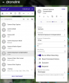
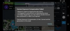
ExposureCompensation failed.PNG

Screenshot_20220318-124418_Dronelink.jpg

Once the offending commanded was removed, the mission flew fine. Below is an example of the ExposureCompensation values from Test4 after removing the Dronelink command Camera Exposure Compensation:

Code:
DJI_0187.DNG    1/500    0
DJI_0188.DNG    1/500    +2
DJI_0189.DNG    1/500    +1
DJI_0190.DNG    1/500    +0.7
DJI_0191.DNG    1/500    +0.7
DJI_0192.DNG    1/500    -0.3
DJI_0193.DNG    1/500    -1.3
DJI_0194.DNG    1/500    -1.7
DJI_0195.DNG    1/500    +1
DJI_0196.DNG    1/500    0
DJI_0197.DNG    1/500    -0.3
DJI_0198.DNG    1/500    +0.7
DJI_0199.DNG    1/500    -0.7
DJI_0200.DNG    1/500    +0.3
DJI_0201.DNG    1/500    0
DJI_0202.DNG    1/500    -1.7
DJI_0203.DNG    1/500    +1
DJI_0204.DNG    1/500    +0.3
DJI_0205.DNG    1/500    +0.7
DJI_0206.DNG    1/500    -0.3
DJI_0207.DNG    1/500    -0.7
DJI_0208.DNG    1/500    +1
DJI_0209.DNG    1/500    +0.3
DJI_0210.DNG    1/500    +1.3
DJI_0211.DNG    1/500    +0.7
DJI_0212.DNG    1/500    +0.3
DJI_0213.DNG    1/500    +0.3
DJI_0214.DNG    1/500    +1.7
DJI_0215.DNG    1/500    +1
DJI_0216.DNG    1/500    -1.3
DJI_0217.DNG    1/500    +0.3
DJI_0218.DNG    1/500    +0.3
DJI_0219.DNG    1/500    +0.3
DJI_0220.DNG    1/500    +0.7
DJI_0221.DNG    1/500    +0.3
DJI_0222.DNG    1/500    -0.3
DJI_0223.DNG    1/500    0
DJI_0224.DNG    1/500    -0.7
DJI_0225.DNG    1/500    0
DJI_0226.DNG    1/500    +0.7
DJI_0227.DNG    1/500    +1.3
DJI_0228.DNG    1/500    +1
DJI_0229.DNG    1/500    +0.7
DJI_0230.DNG    1/500    -0.7
DJI_0231.DNG    1/500    +0.7
DJI_0232.DNG    1/500    0
DJI_0233.DNG    1/500    +1.3
DJI_0234.DNG    1/500    +1.3
DJI_0235.DNG    1/500    +1.3
DJI_0236.DNG    1/500    +1
DJI_0237.DNG    1/500    +1.3
DJI_0238.DNG    1/500    +1
 
Do you really want to be changing exposure during a map run? I'm not an expert at mapping, but any time I want to merge images into something larger I always strive to maintain the same exposure for all shots so post processing is simple (no tweaking of individual exposures to make the sky or background uniform).
 
@eEridani wrote: "Do you really want to be changing exposure during a map run?"
No, absolutely not. You're correct; all images should be uniformly exposed with the same white balance (and focus) too, and that's why I have fixed the shutter speed / ExposureTime, in this example, to 1/500. The camera on the MA2 however is forcing ExposureCompensation for each image making an average change in the EV of about .3 but with a standard deviation of about .8 and a range between -1.7 to 1.7 stops. This is why I was wondering if anybody here knows the correct programming command to send to the MA2 to set the compensation value to zero.
 
No, absolutely not.
Okay - I get it. Somewhere I recently read something about a recent firmware update doing auto exposure even in manual mode ... I'll try to find that link.

Here's one such discussion and how to do the lock:

Some other threads hint the displayed EV is the exposure value the camera would have used, not that it is actually changing; are the images really changing, or is it just the values shown in Dronelink?
 
Last edited:
  • Like
Reactions: kbellis
Dronelink is pretty cool, but I should not have assumed everybody was already familiar with it, though I expect many readers are. Below are just the camera commands that can be used on drones. Not every command can be used on every drone. Some drones like the MA2, are able to receive and implement some of these instructions. And it's possible that there could be commands that Dronelink developers don't yet know about, like for example, if the MA2 can somehow be told to set the ExposureCompensation to zero. This possibility is what inspired this thread. With so many drones constantly coming out, with so many commands to remotely control them available, it's impossible to keep up with them all. Fortunately, the Dronelink developers want to try as they are actively developing and supporting their product.

list-of-dronelink-commands.png
 
@eEridani wrote: "Do you really want to be changing exposure during a map run?"
No, absolutely not. You're correct; all images should be uniformly exposed with the same white balance (and focus) too, and that's why I have fixed the shutter speed / ExposureTime, in this example, to 1/500. The camera on the MA2 however is forcing ExposureCompensation for each image making an average change in the EV of about .3 but with a standard deviation of about .8 and a range between -1.7 to 1.7 stops. This is why I was wondering if anybody here knows the correct programming command to send to the MA2 to set the compensation value to zero.
You would do better if you understood basic photography better.
You want all your images to be properly exposed (not necessarily the same exposure settings), but you've locked down the ISO and shutter speed, so if there are differences in brightness, the camera can't adjust anything to give the correct exposure.

If you use manual exposure, the Exposure Compensation (EV) setting does nothing and the EV number you see on your screen indicates how much the exposure you set differs from what the meter would use.
 
Maybe it is a case of needing AutoExposureLock?
 
You would do better if you understood basic photography better.
You want all your images to be properly exposed (not necessarily the same exposure settings), but you've locked down the ISO and shutter speed, so if there are differences in brightness, the camera can't adjust anything to give the correct exposure.

If you use manual exposure, the Exposure Compensation (EV) setting does nothing and the EV number you see on your screen indicates how much the exposure you set differs from what the meter would use.
@Meta4 - When you're stitching adjacent images, be they for any photogrammetric purpose, point cloud generation, creating an orthomosaic, or even a full 180x360 panorama, manual everything; i.e., ISO, white balance, focus, ƒ/stop, shutter speed, and zero EV compensation is absolutely essential.

Allowing the camera to impose automatic EV correction is unhelpful for mapping purposes in general; for example, all of the following images were taken during my last mapping mission (Test4) and have been unaltered other than to resize them down to 800 pixels in width:

DJI_0214x800_EV+1,7.jpg

DJI_0194x800_EV-1,7.jpg

In the two examples above, the MA2 forced the exposure compensation to the greatest range. In the two examples below, the MA2 also forced the exposure compensation, but which in those two examples happened to be zero. I would like to know if there is any command, method or trick to force the MA2 to not automatically apply any exposure compensation during a mapping mission.

DJI_0196x800_EV0,0.jpg

DJI_0201x800_EV0,0.jpg
 
@Meta4 - When you're stitching adjacent images, be they for any photogrammetric purpose, point cloud generation, creating an orthomosaic, or even a full 180x360 panorama, manual everything; i.e., ISO, white balance, focus, ƒ/stop, shutter speed, and zero EV compensation is absolutely essential.
I would dispute that and repeat that the important thing is for all images to be properly exposed.
If lighting is different for different parts of the composite image, camera settings have to change to achieve proper exposure for each individual image.
In this 3 row panorama, there are brightly lit parts and darker parts of the panorama.
I shoou AEB to allow a choice of exposure settings and mix and match the originals that I stitch to keep proper exposure across the whole panorama.

DJI_0070-85aa-XL.jpg

I want each part to be correctly exposed, not each recorded with the same settings.
If I'm mapping and the light is changing, I don't want parts of the ortho to be underexposed or overexposed because the sunlight was darker or lighter when they were shot.
In the two examples above, the MA2 forced the exposure compensation to the greatest range. In the two examples below, the MA2 also forced the exposure compensation, but which in those two examples happened to be zero. I would like to know if there is any command, method or trick to force the MA2 to not automatically apply any exposure compensation during a mapping mission.
I can't understand how exposure compensation is happening if you are using manual exposure setting.
If it's "forcing exposure compensation, that's auto exposure setting, not manual exposure setting at all.
Can you post one of those original +1.7 images (full size) so I can check the metadata to work out what's going on with the exposure setting.
 
BTW, nice composite of that 3-row pano in Brisbane! Your method is working for you, and quite nicely! So you needn't change a thing in your workflow, nor am I lobbying for you to think about changing what you're doing.

The full manual method that I have used for over 20 years has worked well for me and many others when shooting panos from single shots or HDR bracketed series. And you don't have to take my word on it - exposure settings when shooting a pano.

There are similar fully manual camera considerations in shooting for photogrammetry. While the 3D model in that linked University of Virginia article is on a small scale, the principals still apply when modeling the terrain.

The other aspect that that comes into play, relates less to our own rods and cones, and more with the pixel matching algorithms of the software like PTGui for automated control point generation, as one example. Pixels exposed on par with one another on overlapping images used in photogrammetry missions (front overlap 80%, side overlap %70) help in defining the 3D point cloud, the base element from which meshes are produced, digital elevation models created, and lastly the spatial framework and surface which the imagery gets projected onto resulting in ortho rectified imagery.
 
Last edited:
  • Like
Reactions: Meta4
>>>>>IGNORE<<<<<<
>>>>> Data from an incorrect image <<<<<

Here's a small part of the image metadata to show what's going one with the exposure setting for that image
I've highlighted the relevant part.
i-tC9mTQB.jpg


According to the data, the image wasn't shot using manual exposure.
it was shot using AE Program mode where the camera uses its best guess at what's likely to give good exposure.
I'm guessing that somewhere in the dronelink settings, you've allowed auto exposure, but that's not necessarily a bad thing.
But on top of that, you have the Exposure Compensation manually dialled in to over expose by two stops above the camera's exposure choice.
This is handicapping your mapping as it overexposes the images and forces a slower shutter speed than you really want for mapping flights.
If EV was at zero, you would have had proper exposure at 1/125th sec, which would have been better for mapping on the fly.

Look a little closer at your Dronelink settings as it's not doing what you thought it was.
And dial back the EV in DJI Go 4 to 0 (or even -0.3).
 
Last edited:
  • Like
Reactions: midlifecrisis
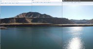
Here's an example of three images taken for one of my panos. The files claim a 1.7 stop difference in "Exposure Bias" ... but looking at the hillside the brightness is the same across all three. The water is 99% reflection, the sky also has reflected polarized light, so they don't count as the drone camera was rotating between shots. Based on this, I wonder if the exposure bias shown in the metadata is real, or something in camera?

1647762796807.png

1647762992318.png

1647763273934.png
 
  • Like
Reactions: kbellis
Here's a small part of the image metadata to show what's going one with the exposure setting for that image
I've highlighted the relevant part.
i-tC9mTQB.jpg
Thank you for taking the time to look at the meta, but the data that you've presented above is wrong and incomplete, please check and try again. Also, please provide the application that you're running to expose the meta as it looks quite nice.

At first I wondered if the forum software did something peculiar to the file that I uploaded, so I download it and looked at everything, none of which comes even close to what you're showing, and it compared verbatim with its original.

Below is the extracted data using Phil Harvey's ExifTool:
Code:
---- ExifTool ----
ExifTool Version Number         : 12.24
Warning                         : [minor] Bad MakerNotes directory
Warning                         : [minor] Bad format (25698) for MakerNotes entry 0
---- File ----
File Name                       : Downloaded DJI_0214 from MavicPilots.JPG
Directory                       : .
File Size                       : 6.1 MiB
File Modification Date/Time     : 2022:03:20 07:27:47-04:00
File Access Date/Time           : 2022:03:20 07:34:11-04:00
File Creation Date/Time         : 2022:03:20 07:27:47-04:00
File Permissions                : -rw-rw-rw-
File Type                       : JPEG
File Type Extension             : jpg
MIME Type                       : image/jpeg
Exif Byte Order                 : Little-endian (Intel, II)
Image Width                     : 4000
Image Height                    : 3000
Encoding Process                : Baseline DCT, Huffman coding
Bits Per Sample                 : 8
Color Components                : 3
Y Cb Cr Sub Sampling            : YCbCr4:2:0 (2 2)
---- EXIF ----
Image Width                     : 4000
Image Height                    : 3000
Bits Per Sample                 : 8 8 8
Image Description               : default
Make                            : DJI
Camera Model Name               : FC3170
Orientation                     : Horizontal (normal)
Samples Per Pixel               : 3
X Resolution                    : 72
Y Resolution                    : 72
Resolution Unit                 : inches
Software                        : 10.00.17.64
Modify Date                     : 2022:03:18 12:52:22
Y Cb Cr Positioning             : Centered
Exposure Time                   : 1/500
F Number                        : 2.8
Exposure Program                : Manual
ISO                             : 100
Exif Version                    : 0230
Date/Time Original              : 2022:03:18 12:52:22
Create Date                     : 2022:03:18 12:52:22
Components Configuration        : Y, Cb, Cr, -
Exposure Compensation           : +1.7
Max Aperture Value              : 2.8
Metering Mode                   : Spot
Light Source                    : Unknown
Flash                           : No Flash
Focal Length                    : 4.5 mm
Flashpix Version                : 0100
Color Space                     : sRGB
Exif Image Width                : 4000
Exif Image Height               : 3000
Interoperability Index          : R98 - DCF basic file (sRGB)
Interoperability Version        : 0100
File Source                     : Digital Camera
Scene Type                      : Directly photographed
Exposure Mode                   : Manual
White Balance                   : Manual
Digital Zoom Ratio              : 1
Focal Length In 35mm Format     : 24 mm
Scene Capture Type              : Standard
Gain Control                    : None
Contrast                        : Normal
Saturation                      : Normal
Sharpness                       : Normal
Device Setting Description      : (Binary data 4 bytes, use -b option to extract)
Serial Number                   : 1TCTHA603BJ4K2
Lens Info                       : 24mm f/2.8
GPS Version ID                  : 2.3.0.0
GPS Latitude Ref                : North
GPS Latitude                    : 44.544475°
GPS Longitude Ref               : West
GPS Longitude                   : 68.416751°
GPS Altitude Ref                : Above Sea Level
GPS Altitude                    : 34.7 m
XP Comment                      : 0.9.142
XP Keywords                     : single
Image Width                     : 160
Image Height                    : 120
Compression                     : JPEG
X Resolution                    : 72
Y Resolution                    : 72
Resolution Unit                 : inches
Thumbnail Offset                : 24970
Thumbnail Length                : 11569
Thumbnail Image                 : (Binary data 11569 bytes, use -b option to extract)
---- XMP ----
About                           : DJI Meta Data
Modify Date                     : 1970:01:01
Create Date                     : 1970:01:01
Make                            : DJI
Camera Model Name               : Test_Pro
Format                          : image/jpg
GPS Latitude                    : 44.544475° N
GPS Longitude                   : 68.416751° W
Absolute Altitude               : +34.70
Relative Altitude               : +34.70
Gimbal Roll Degree              : +0.00
Gimbal Yaw Degree               : -69.60
Gimbal Pitch Degree             : -89.90
Flight Roll Degree              : +2.10
Flight Yaw Degree               : -89.90
Flight Pitch Degree             : -3.70
Cam Reverse                     : 0
Gimbal Reverse                  : 0
Self Data                       : dronelink:3.3.1
Version                         : 7.0
Has Settings                    : False
Has Crop                        : False
Already Applied                 : False
---- MPF ----
MPF Version                     : 0100
Number Of Images                : 2
MP Image Flags                  : Representative image, Dependent parent image
MP Image Format                 : JPEG
MP Image Type                   : Baseline MP Primary Image
MP Image Length                 : 5641019
MP Image Start                  : 0
Dependent Image 1 Entry Number  : 0
Dependent Image 2 Entry Number  : 2
MP Image Flags                  : Dependent child image
MP Image Format                 : JPEG
MP Image Type                   : Large Thumbnail (VGA equivalent)
MP Image Length                 : 767441
MP Image Start                  : 5649211
Dependent Image 1 Entry Number  : 0
Dependent Image 2 Entry Number  : 0
Image UID List                  : (Binary data 66 bytes, use -b option to extract)
Total Frames                    : 1
Preview Image                   : (Binary data 767441 bytes, use -b option to extract)
---- Composite ----
Aperture                        : 2.8
Shutter Speed                   : 1/500
GPS Altitude                    : 34.7 m Above Sea Level
GPS Latitude                    : 44.544475° N
GPS Longitude                   : 68.416751° W
GPS Position                    : 44.544475° N, 68.416751° W
Image Size                      : 4000x3000
Light Value                     : 11.9
Megapixels                      : 12.0
Scale Factor To 35 mm Equivalent: 5.3
Circle Of Confusion             : 0.006 mm
Field Of View                   : 73.7 deg
Focal Length                    : 4.5 mm (35 mm equivalent: 24.0 mm)
Hyperfocal Distance             : 1.28 m
 
Here's an example of three images taken for one of my panos. The files claim a 1.7 stop difference in "Exposure Bias" ... but looking at the hillside the brightness is the same across all three. The water is 99% reflection, the sky also has reflected polarized light, so they don't count as the drone camera was rotating between shots. Based on this, I wonder if the exposure bias shown in the metadata is real, or something in camera?

View attachment 145511

View attachment 145512

View attachment 145513
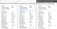
@eEridani - Thank you for posting the properties from the exact aircraft we're discussing and for the great side by side comparison of the FC3170's images shot last November and their Details.

I agree with you that "looking at the hillside the brightness is the same across all three". Just to make sure that we're on the same page, could you please confirm that these images were all shot with Exposure Program: Manual?
 
As for your point concerning displayed/ reported EV compensation vs. reality, you've nailed it. In my examination above (#8) that's exactly what I was trying to understand. Dronelink mapping mission Test4 was tonally improved, but no cigar.

More tests soon after I've dealt with the replacement for my defective first purchase that was exchanged Friday night at Best Buy for a second MA2; another story for another thread - still waiting to hear back from DJI support regarding the 2 out of 3 batteries that suddenly stopped taking a charge.
 
Thank you for taking the time to look at the meta, but the data that you've presented above is wrong and incomplete, please check and try again.
Thanks ... the data I quoted is from a different image.
I'll look at the correct one again soon and get back about it.
Thank you for taking the time to look at the meta, but the data that you've presented above is wrong and incomplete, please check and try again. Also, please provide the application that you're running to expose the meta as it looks quite nice.
Sorry about the confusion.
The data from the correct image shows that it was shot using Manual Exposure Mode.
You cannot have exposure compensation in Manual Mode and the settings you make should be the settings you get.

The EV number that DJI displays would be that it's the difference between the exposure settings that the meter would use and what you set.
But the image itself doesn't look like it's 1.7 stops over exposed, so I'm not sure.

This is probably because the data shows that the meter is in Spot Metering Mode.
Instead of looking at an average value for the whole frame, it's looking at just a small spot in the centre of each frame.
The exposure comparison will depend on how bright or dark that spot is.
This would explain the varying EV numbers across your project.

i-Z6B2NdZ.jpg
 
Last edited:
This is probably because the data shows that the meter is in Spot Metering Mode.
Instead of looking at an average value for the whole frame, it's looking at just a small spot in the centre of each frame.
The exposure comparison will depend on how bright or dark that spot is.
This would explain the varying EV numbers across your project.

That makes sense. Still **** frustrating having to go through a forensic necropsy in order to understand the allowed camera commands for the Mavic Air 2. More experiments to follow!
 
Played some more with the camera settings. I can confirm that when in PRO mode, the EV values become meter readings (EV changes to M.M on the UI), no longer applied compensation values. My 1.5.10-1070 version of DJI Fly, I have only PRO and AUTO modes, there is no MANUAL mode that I can find. Update: the word MANUAL is showing in the EXIF data for Exposure Program, but pretty certain all I did was use EV Lock.

EV Lock does lock EV, but is only available via RC button presses. On the smart controller, it is up press on the 5-way button. There is no UI indication EV Lock is on or off. In PRO mode it disables ISO changes. In AUTO mode it appears to disable EV step changes.

Metering mode changes between SPOT and AVERAGE based on screen touches.

At this point, I'd strongly suggest you attempt to use the AE Lock function, there is such a command in your Camera command list.
 
  • Like
Reactions: kbellis
@eEridani - Your Smart RC controller sounds interesting! That wasn't included in the MA2 Fly More Combo box. In the Dronelink Android app, there is an EV lock, but I only played with it a little as it presented an issue I didn't want to deal with at the time.

Thank you for helping to highlight the fact we're dealing with three discrete lexicons; i.e.,
  • Exif tag names
  • DJI names
  • Dronelink named commands
Without further burdening you, or any others reading this, are you using Dronelink for your mapping missions? I'm sensing not. I may abandon further postings about Dronelink on the MavicPilots forum if that's the case.

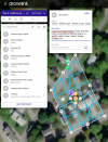
Flew my first mapping test successfully with my replacement MA2 yesterday with the following commands (screenshot below), noting the commands which failed in the description. The test was actively modified in the field ad how after each failed command and then reattempted until the mission ran as intended.

20220320_test6 Dronelink mission components.PNG

For unknown reasons the Dronelink display on my Android device didn't show the video feed from the MA2; however, that didn't impact performance. This was the first and only flight with the new MA2, was directly over our house and always within sight. It may have been related to how many mission aborts and the reloading of the revised new missions were done without full power cycles, etc.. It was nice being able to make mission edits ad hoc, but this is all new for me, so I may have not followed the preferred workflow while in the field.

Below is the relevant EXIF data, which by the way is from using Phil Harvey's outstanding program with the following command line switches in case you want to try it yourself, just change the paths to your system :)

Code:
exiftool -T -r -filename -exposureprogram -meteringmode -exposuremode -exposuretime -exposurecompensation -whitebalance  "L:/images/Mavic Air 2/20220320 dronelink mission Test6/20220320_JPG" > "L:/images/Mavic Air 2/20220320 dronelink mission Test6/20220320_JPG/out.txt"

Code:
DJI_0004.JPG    Manual    Average    Manual    1/500    -0.3    Manual
DJI_0005.JPG    Manual    Average    Manual    1/500    -0.3    Manual
DJI_0006.JPG    Manual    Average    Manual    1/500    -0.3    Manual
DJI_0007.JPG    Manual    Average    Manual    1/500    -0.7    Manual
DJI_0008.JPG    Manual    Average    Manual    1/500    -0.7    Manual
DJI_0009.JPG    Manual    Average    Manual    1/500    -0.7    Manual
DJI_0010.JPG    Manual    Average    Manual    1/500    -0.3    Manual
DJI_0011.JPG    Manual    Average    Manual    1/500    -0.3    Manual
DJI_0012.JPG    Manual    Average    Manual    1/500    -0.3    Manual
DJI_0013.JPG    Manual    Average    Manual    1/500    -0.3    Manual
DJI_0014.JPG    Manual    Average    Manual    1/500    -0.3    Manual
DJI_0015.JPG    Manual    Average    Manual    1/500    -0.7    Manual
DJI_0016.JPG    Manual    Average    Manual    1/500    -1    Manual
DJI_0017.JPG    Manual    Average    Manual    1/500    -0.7    Manual
DJI_0018.JPG    Manual    Average    Manual    1/500    -0.7    Manual
DJI_0019.JPG    Manual    Average    Manual    1/500    -0.7    Manual
DJI_0020.JPG    Manual    Average    Manual    1/500    -0.7    Manual
DJI_0021.JPG    Manual    Average    Manual    1/500    -0.7    Manual
DJI_0022.JPG    Manual    Average    Manual    1/500    -0.3    Manual
DJI_0023.JPG    Manual    Average    Manual    1/500    0    Manual
DJI_0024.JPG    Manual    Average    Manual    1/500    -0.3    Manual
DJI_0025.JPG    Manual    Average    Manual    1/500    -0.3    Manual
DJI_0026.JPG    Manual    Average    Manual    1/500    -0.3    Manual
DJI_0027.JPG    Manual    Average    Manual    1/500    -0.7    Manual
DJI_0028.JPG    Manual    Average    Manual    1/500    -1    Manual
DJI_0029.JPG    Manual    Average    Manual    1/500    -1    Manual
DJI_0030.JPG    Manual    Average    Manual    1/500    -0.7    Manual
DJI_0031.JPG    Manual    Average    Manual    1/500    -0.7    Manual
DJI_0032.JPG    Manual    Average    Manual    1/500    -1    Manual
DJI_0033.JPG    Manual    Average    Manual    1/500    -1    Manual
DJI_0034.JPG    Manual    Average    Manual    1/500    -1    Manual
DJI_0035.JPG    Manual    Average    Manual    1/500    -1    Manual
DJI_0036.JPG    Manual    Average    Manual    1/500    -1    Manual
DJI_0037.JPG    Manual    Average    Manual    1/500    -1    Manual
DJI_0038.JPG    Manual    Average    Manual    1/500    -1    Manual
DJI_0039.JPG    Manual    Average    Manual    1/500    -0.7    Manual
DJI_0040.JPG    Manual    Average    Manual    1/500    -0.7    Manual
DJI_0041.JPG    Manual    Average    Manual    1/500    -1    Manual
DJI_0042.JPG    Manual    Average    Manual    1/500    -1.3    Manual
DJI_0043.JPG    Manual    Average    Manual    1/500    -1.3    Manual
DJI_0044.JPG    Manual    Average    Manual    1/500    -1.3    Manual
DJI_0045.JPG    Manual    Average    Manual    1/500    -1    Manual
DJI_0046.JPG    Manual    Average    Manual    1/500    -1    Manual
DJI_0047.JPG    Manual    Average    Manual    1/500    -1    Manual
DJI_0048.JPG    Manual    Average    Manual    1/500    -1    Manual
DJI_0049.JPG    Manual    Average    Manual    1/500    -1.7    Manual
DJI_0050.JPG    Manual    Average    Manual    1/500    -1.3    Manual
DJI_0051.JPG    Manual    Average    Manual    1/500    -1    Manual
DJI_0052.JPG    Manual    Average    Manual    1/500    -1    Manual
DJI_0053.JPG    Manual    Average    Manual    1/500    -0.7    Manual
DJI_0054.JPG    Manual    Average    Manual    1/500    -0.7    Manual
DJI_0055.JPG    Manual    Average    Manual    1/500    -0.7    Manual
DJI_0056.JPG    Manual    Average    Manual    1/500    -0.7    Manual
DJI_0057.JPG    Manual    Average    Manual    1/500    -0.3    Manual
DJI_0058.JPG    Manual    Average    Manual    1/500    -0.7    Manual
DJI_0059.JPG    Manual    Average    Manual    1/500    -0.7    Manual
DJI_0060.JPG    Manual    Average    Manual    1/500    -0.7    Manual
DJI_0061.JPG    Manual    Average    Manual    1/500    -1    Manual
DJI_0062.JPG    Manual    Average    Manual    1/500    -1.3    Manual
out.txt    -    -    -    -    -    -

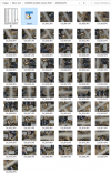
Very quickly glancing at the thumbnails:

Glance at thumbnails.PNG

As previously observed and noted by Meta4, the reported (EXIF) EVs can be visually correlated with their respective images; however, the images are not showing the typical tonal range associated with those values recorded in the EXIF. I have no idea how this gets explained and even less expectation that DJI will ever do so, but maybe, DJI will fix this. Note in this test, the metering mode setting was Average (not Spot).

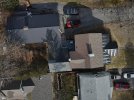
For example, the darkest looking image is DJI_0049 with the reported exposure compensation of -1.7:

DJI_0049x800.jpg

This image does look slightly underexposed compared with its companions, but it isn't as underexposed as reported (-1.7). If that were true, then increasing its exposure by the reported value, the image should look reasonably improved; however, let's try to prove it and see.

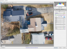
Because I also collected the images in raw format, we can play with them in Adobe Camera Raw (ACR) and adjusting the exposure by 1.7 looks way whacked! DJI may want to study this more deeply. Please.

DJI_0049 DNG in ACR.PNG
 
Lycus Tech Mavic Air 3 Case

DJI Drone Deals

New Threads

Forum statistics

Threads
131,070
Messages
1,559,522
Members
160,050
Latest member
invertedloser