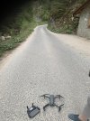
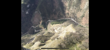
Client wants one single shot at 400 meters. Drone is Mavic 2 Pro.
I have spoken with the local authorities on obtaining a permit for a flight that is 400 meters.
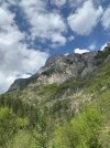
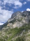
They are fine with the height but I will not be able to move from the take off site. It will be straight up to capture it.
Is anything I should do to maintain a signal with the drone directly overhead at 400 meters?
I would appreciate it if anyone has any advice or comments on this so I can avoid complications or disaster during this commercial activity.
Thanks for any help!
I have spoken with the local authorities on obtaining a permit for a flight that is 400 meters.
They are fine with the height but I will not be able to move from the take off site. It will be straight up to capture it.
Is anything I should do to maintain a signal with the drone directly overhead at 400 meters?
I would appreciate it if anyone has any advice or comments on this so I can avoid complications or disaster during this commercial activity.
Thanks for any help!