DJI Mavic, Air and Mini Drones
Friendly, Helpful & Knowledgeable Community
Join Us Now

Crashed mini 1, but not sure why

dronequest

New Member
Joined
Mar 26, 2022
Messages
2
Reactions
0
Age
36
Location
Georgia
Here is the flight log. As you can see it was a short one. I flew it out in front of me and rotated it for a picture. It then just took off in to the side of a building and I couldn't correct fast enough. Was this user error or a malfunction. The only thing I can think of is that I launched before it had a good satellite lock. Thanks!

DJI Flight Log Viewer | Phantom Help
 
... Was this user error or a malfunction...
Hi there & welcome to the forum ... even though it's due to unfortunate circumstances.

Yeah ... definitely user error, no doubt about that.

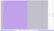
In below chart you have your whole flight, the horizontal axis is time & to the right vertical, the different graph axis.

The 2 color background bands to the left is motor start & auto take-off ... the purple background is where the Visual Positional Sensor could lock on to the surface below the drone & provide horizontal position hold ... the grey background is where the VPS sensor couldn't lock on & provide horizontal position hold.

During this short flight you mostly had 0 satellites locked (red graph), just in the end it locked to 4... this meant that the GPSLevel (green graph) was 0 (a Home point is recorded when it reaches 4 out of max 5).

Have placed the chart marker at 23,4sec into the flight ... just there you rotated the drone for a picture, and right there the VPS sensors couldn't provide any horizontal position hold anymore. This together with that you there had 0 satellites locked = 0 in GPSLevel ... meant that you lost all horizontal position hold.

This meant that all outside forces like winds would move your drone freely ... and all braking after releasing the sticks didn't work anymore, the drone would just continue to drift after releasing a stick command.

Sorry, but this was all on you being ignorant about what makes your drone hover in position, brake after stick release & fly stable.

(Click on the chart to make it larger)
1648311865161.png
 
Thanks for taking a look. I figured it was on me. If i had waited until the satellites locked would that have made a difference? Also, I launched it from a condo balcony on the 10th floor so it went from hovering 5 ft up to 100 ft up. Would that have been ok if I had waited?
 
As I understand it, yes you should have waited for the HP to be set. Without that the drone doesnt know where it's at. You most likely would have an issue picking up the satellites because of the buildings. The vps system isnt perfect, it needs contrast to work it's best.
Sorry for the loss.
 
Ideally you don't take off before the "lady voice" have announced that a HP have been recorded ... & then you do what she tells you, you check on the map so it's in the correct place ... now you take off.

If the sky is shielded at ground level some experienced ascend straight up & keep it in place hovering with gentle stick inputs right over the launch spot until the "lady voice" ... & you have a recorded HP, then fly out.

The VPS sensor is meant to assist horizontal position hold when for instance flying in places where you can't have a GPS lock ... like indoors. The sensors on a Mini can assist accurately up to 10m (33ft) if the light is enough & the surface below is good enough so the sensor can lock to the pattern.

If doing like you did, going from a height of 5ft to a sudden height above ground of 100ft ... yeah, there you have disabled any horizontal position hold from the VPS sensor in one blow ... if you there also lack a enough high quality GPS lock then you're totally on your own regarding keeping the horizontal position, counteract to outside coming forces that affect your Mini (wind) ... & manually brake the drone when you release the sticks (doing gentle opposite stick moves shortly to stop the motion). Handle a drone in this state can be rather difficult & confusing for a untrained, nothing you should do in tight locations without a lot of practice.

Recommend you to read through the full downloadable user manual for your Mini...
Get it here --> https://dl.djicdn.com/downloads/Mavic_Mini/Mavic_Mini_User_Manual_v1.0_en_1.pdf
(check from page 15 for all about the Vision system)
 
Off at a tangent to the original question, but connected - I have just searched the myriad of folders within the DJI folder but cannot find any flight logs at all.

Can anybody help please?
 
Here is the flight log. As you can see it was a short one. I flew it out in front of me and rotated it for a picture. It then just took off in to the side of a building and I couldn't correct fast enough. Was this user error or a malfunction. The only thing I can think of is that I launched before it had a good satellite lock. Thanks!

DJI Flight Log Viewer | Phantom Help
One other situation to be aware of, is one where you are flying in close proximity to large electric motors or other similar electrical operations.
Last season, I was amongst operating grain elevators when.....yup, Mini 1 suddenly had an 'attraction' for a grain bin. Like a dog in heat. Crashed. No damage though!
Farmer said, "Huh, my truck radio goes wonky when I enter this area..."
So....drone signal got hugely messed up.
Lesson learned.
 
During this short flight you mostly had 0 satellites locked (red graph), just in the end it locked to 4... this meant that the GPSLevel (green graph) was 0 (a Home point is recorded when it reaches 4 out of max 5).
Is this specific to the Mini-1?

On my Mini-2s, it sets the homepoint when it sees 9 or 10 sats, and I frequently get 15 - 18 sats during the course of a flight.

Thx,

TCS
 
Is this specific to the Mini-1?

On my Mini-2s, it sets the homepoint when it sees 9 or 10 sats, and I frequently get 15 - 18 sats during the course of a flight.

Thx,

TCS
The number of satellites locked alone aren't relevant when it comes to when the flight controller start to trust the GPS positional data ... the GPSLevel is a value in the flight log going from 0 (worst) to 5 (best). A home point is never recorded before the GPSLevel reaches 4 ... & before that the drone either rely on the VPS sensor to provide horizontal position hold, and if that doesn't work (too dark, outside the sensor range or the surface hasn't a suitable pattern) ... it falls back to ATTI.

And no ... this isn't specific to a Mini 1, all DJI crafts work like this.
 
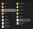
Where to find your flight data is in the instructions in this link.
http://www.phantomhelp [QUOTE="Meta...www.phantomhelp.com/LogViewer/Upload/[/QUOTE]
Thanks for trying to help. I'd already been there and gone to
DJI Fly
  • DJI\dji.go.v5\
but as you can see from the screen shot, there is no folder for FlightRecord. I even checked in all other folders. I then tried 'SD REFRESH' as this is mentioned, to no effect. Any other suggestions please?
 

Attachments

  • DJI.jpg
    DJI.jpg
    46.2 KB · Views: 6
The number of satellites locked alone aren't relevant when it comes to when the flight controller start to trust the GPS positional data ... the GPSLevel is a value in the flight log going from 0 (worst) to 5 (best). A home point is never recorded before the GPSLevel reaches 4 ... & before that the drone either rely on the VPS sensor to provide horizontal position hold, and if that doesn't work (too dark, outside the sensor range or the surface hasn't a suitable pattern) ... it falls back to ATTI.

And no ... this isn't specific to a Mini 1, all DJI crafts work like this.
Interesting. My sat count is almost always 9 or 10 when the home point gets set, which isn't surprising since I've only flown from one place so far. When flying from just one location, I guess sat count is a pretty good proxy for GPS Level.

I haven't gotten into reviewing the logs yet.

I always wait until the Fly Lady tells me the homepoint is set before taking off.

Thx!

TCS
 

Interesting. My sat count is almost always 9 or 10 when the home point gets set, which isn't surprising since I've only flown from one place so far. When flying from just one location, I guess sat count is a pretty good proxy for GPS Level.
From 1 or 100 locations doesn't matter.
The sats in your sky are changing all the time, with sats on their individual orbits and the earth rotation on its axis inside the cage they form around the earth.

And number of sats is not the important thing.
You need enough sats AND they have to be spread to give good geometry for triangulation.
Sats close together in the sky aren't good for that.
With modern drones like the M3 using 3 different sat systems, the sky is crowded and sats get bunched so that the number of sats can give a false impression.

Here's a plot of sats in the sky hat one time.
See how some are too close for them all to be useful.
Others that are too close to the horizon are not good for reliable use too
The number of sats can be very misleading.
i-qJm6gpZ-L.jpg

 
  • Like
Reactions: MS Coast
I'm not offering any kind of detailed theoretical technical explanation.

I'm describing what I've observed on many dozens of flights.

If relevant data isn't displayed on the screen, it's *NOT* relevant for in-flight ops.

In my actual flight conditions, waiting to get Fly Lady to give me the Go Code, watching the number of sats increase, I can quite reliably count on getting the Go Code when I have 9 or 10 sats.

Suppose your technical description is entirely correct, which I don't dispute. So what, in terms of data that I actually have in real time?

You can listen to what someone is saying to understand what they mean, or you can listen to find a way to make them wrong.

There's too much of the latter on this list for my liking...

TCS
 
In my actual flight conditions, waiting to get Fly Lady to give me the Go Code, watching the number of sats increase, I can quite reliably count on getting the Go Code when I have 9 or 10 sats.
The number might often be 9 or 10, but it won't always and you can't count on it because teh flight controller doesn't count to 10 and *bingo* you have a homepoint.
The flight controller looks at the data it's getting from GPS and when it's happy that the data reliability is good enough, then you get a homepoint.
And sometimes that will take more than 10 sats, because the number of sats is irrelevant (as long as there are >6).
Suppose your technical description is entirely correct, which I don't dispute. So what, in terms of data that I actually have in real time?
Watch the GPS icon on screen .. when it changes colour to white, then you have good GPS and a homepoint.
 
The number might often be 9 or 10, but it won't always and you can't count on it
In the 10 months that I've been flying...all from the same location...it has always been 9 or 10. Every time.

I don't "count on it" in the sense of making any decisions based on the count. Waiting to get enough signal to fly is like watching paint dry, and the sat count gives me a very reliable indication of how quickly that's progressing. I don't take off until the Fly Lady says Go...which has, in every case, been with 9 or 10 sats.

I'm not saying that the sat count determines when that happens, but in my actual conditions, it's an entirely reliable indicator of when that's going to happen.
And sometimes that will take more than 10 sats, because the number of sats is irrelevant (as long as there are >6).
You're talking about theory, and I'm talking about observation. In theory, you are correct. In my actual flight conditions it's a very reliable indicator. Which, NB, is very different from saying it's the cause.

Watch the GPS icon on screen .. when it changes colour to white, then you have good GPS and a homepoint.
I always do. And, as a matter of observation, I get 9 or 10 sats, and it turns from red to white, and the Fly Lady says Go, all happens at the same time.

Observations can't falsify the real explanation, and the real explanation can't falsify observations.

TCS
 
You're talking about theory, and I'm talking about observation.
I wasn't talking about theory .. I was talking about what actually happens and that can easily be observed if you read the flight data.
Your GPS icon will turn white and the homepoint will be recorded when the flight controller determines that the GPS reliability is 4/5 or 5/5.
And above I gave you some background explaining what goes into that and why the number of satellites is not what what matters.

If you don't want to bother with the details, just watch that icon and wait for it to turn white.
I believe you. I don't dispute any of that.

That's just not what I was talking about.

I was talking about what I see.

Theory or mechanism or process description are interchangeable in this context, in that they are all orthogonal to what I see.

What point are you trying to make that you think I haven't already agreed to?

TCS
 
Lycus Tech Mavic Air 3 Case

DJI Drone Deals

New Threads

Forum statistics

Threads
130,926
Messages
1,557,938
Members
159,928
Latest member
ENJOYBIKE