Hi all, I hope you are all well in this time of COVID.
I would like some feedback please on what exactly went on with my sons 3rd flight with his new Mavic Mini which has now gone missing.
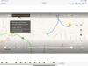
Home return point altitude set to 90 meters Son said to me.
I have uploaded the flight route from take off to the last point it was shown at an altitude of 66 mts -0.5 m/s 0.25 seconds into the flight he got an high wind warning return to home so he asked his sister again what was the wind speed around Prescot Merseyside on her iPhone mobile and it was showing 19mph for our area that day when the drone was at H 30 D 61
I don’t understand the pattern it took and as my son is totally new and his first time using a Mavic Mini drone because I was inside the house he must of panicked not really knowing what was Going on only seeing all the alerts on the screen. To cut a long story short as you can see from the short flight video recording the drone was all over the place but my son did say soon as he seen the alert for unable to auto return to home he did it manually but as you can see another alert shows 1.48 mins into the flight with a weak signal antenna alert so was this because of my son not pointing the controller in the right direction or was the houses blocking the signal.
2.07 mins into the flight and you can see the drone heading home but the it gets side shifted until 2.35 mins into the flight then it is flying in a backwards Position until 2.51 mins into the flight at an altitude of between H 80 - 63 then at 2.53 mins it turns into the other direction onto its final flight path which looks like it’s dropping altitude rapidly until it reaches 3.26 mins into the flight and again the drone turns facing backwards while travelling at H 45 D 310 meters then at 3.27 mins into the flight the “FAIL SAFE MODE“ in progress alert kicks in.
The drone was hovering at an altitude of 89 H meters 378 D meters from Home Point at 3.45 mins on the video then it shows it falling in altitude at a rate of -1.7 then -0.5 then it stops falling in altitude at H 86 meters to me it looks as if the drone tried to hover again the rapidly drops to H 66 meters then after that it went missing and only the last gps point shows where it could of landed or fell but within a few minutes we got in the car and drove round to the last location on the flight recording map and it’s waste land fenced off very high from new build pensioner bungalow homes and we searched for hours along the perimeter fence and in the highish grass also we looked at the back of the waste land towards the houses that back onto this land spoke to a few people who let us search their gardens but no drone in sight.
There is two trees very high ones but the last location on the flight map shows it away from the trees on the arrow marker location of the drone so this is so frustrating because we drove to the last location within 2 minutes nobody was there on the waste land we jumped over searched and searched but absolutely no drone in sight so could it possibly at the last arrow marker location at an altitude of H 66 meters dropped Straight to the ground or could it of blown say another 10 or 20 meters away or even further at the point of total loss communication with the drone.
I have a pro metal detector that can seek different metals and I was thinking because of the copper rotor motors would it help locate if we have missed this drone being mini in the overgrown grass because it’s not about the money the drone cost but I am dying to know where it ended as I just got myself into investigator analysis mode and won’t stop until I find it also I have made posters offering £100 reward if anyone finds it and I’m not bothered if it’s smashes as long as I can identify the drone serial number with the original box etc
I appreciate all your feedback and even the slightest bit of intel on the flight map of what went wrong and if you think it’s dropped rapidly to the ground or carried on flying when the last point of contact was made at 66 meters altitude.
Thank you so much in advance for you help.
Best regards
Mark
I would like some feedback please on what exactly went on with my sons 3rd flight with his new Mavic Mini which has now gone missing.
Home return point altitude set to 90 meters Son said to me.
I have uploaded the flight route from take off to the last point it was shown at an altitude of 66 mts -0.5 m/s 0.25 seconds into the flight he got an high wind warning return to home so he asked his sister again what was the wind speed around Prescot Merseyside on her iPhone mobile and it was showing 19mph for our area that day when the drone was at H 30 D 61
I don’t understand the pattern it took and as my son is totally new and his first time using a Mavic Mini drone because I was inside the house he must of panicked not really knowing what was Going on only seeing all the alerts on the screen. To cut a long story short as you can see from the short flight video recording the drone was all over the place but my son did say soon as he seen the alert for unable to auto return to home he did it manually but as you can see another alert shows 1.48 mins into the flight with a weak signal antenna alert so was this because of my son not pointing the controller in the right direction or was the houses blocking the signal.
2.07 mins into the flight and you can see the drone heading home but the it gets side shifted until 2.35 mins into the flight then it is flying in a backwards Position until 2.51 mins into the flight at an altitude of between H 80 - 63 then at 2.53 mins it turns into the other direction onto its final flight path which looks like it’s dropping altitude rapidly until it reaches 3.26 mins into the flight and again the drone turns facing backwards while travelling at H 45 D 310 meters then at 3.27 mins into the flight the “FAIL SAFE MODE“ in progress alert kicks in.
The drone was hovering at an altitude of 89 H meters 378 D meters from Home Point at 3.45 mins on the video then it shows it falling in altitude at a rate of -1.7 then -0.5 then it stops falling in altitude at H 86 meters to me it looks as if the drone tried to hover again the rapidly drops to H 66 meters then after that it went missing and only the last gps point shows where it could of landed or fell but within a few minutes we got in the car and drove round to the last location on the flight recording map and it’s waste land fenced off very high from new build pensioner bungalow homes and we searched for hours along the perimeter fence and in the highish grass also we looked at the back of the waste land towards the houses that back onto this land spoke to a few people who let us search their gardens but no drone in sight.
There is two trees very high ones but the last location on the flight map shows it away from the trees on the arrow marker location of the drone so this is so frustrating because we drove to the last location within 2 minutes nobody was there on the waste land we jumped over searched and searched but absolutely no drone in sight so could it possibly at the last arrow marker location at an altitude of H 66 meters dropped Straight to the ground or could it of blown say another 10 or 20 meters away or even further at the point of total loss communication with the drone.
I have a pro metal detector that can seek different metals and I was thinking because of the copper rotor motors would it help locate if we have missed this drone being mini in the overgrown grass because it’s not about the money the drone cost but I am dying to know where it ended as I just got myself into investigator analysis mode and won’t stop until I find it also I have made posters offering £100 reward if anyone finds it and I’m not bothered if it’s smashes as long as I can identify the drone serial number with the original box etc
I appreciate all your feedback and even the slightest bit of intel on the flight map of what went wrong and if you think it’s dropped rapidly to the ground or carried on flying when the last point of contact was made at 66 meters altitude.
Thank you so much in advance for you help.
Best regards
Mark