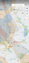
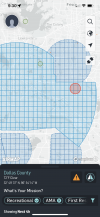
The two attached images are screenshots of DJI Fly and AirMap advising me of flight restrictions in Dallas, Texas's "East Dallas" area. As as reference, you can see White Rock Lake roughly in the middle of the right side.
The difference in indicated restrictions is striking. AirMap says virtually everything between US 75 (Central Expressway) and White Rock Lake is restricted airspace, whereas DJI Fly shows no restrictions for much of the area. DJI's restrictions start a few miles west of AirMap's.
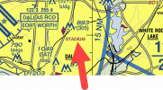
This is FAA's official map, which backs up AirMap: ArcGIS Web Application
What is going on? Either DJI Fly is missing crucial information, or somehow those class B restrictions do not apply to me? I am using a DJI Mini 2, which appears to be restricted to 400 feet regardless? FAA's guidance is awful: dense and confusing. I am wondering if you thread the needle through them correctly, you end up with that if you have sub-250 gram drones, that you have more freedom to fly in restricted airspace that heavier drones don't?
The difference in indicated restrictions is striking. AirMap says virtually everything between US 75 (Central Expressway) and White Rock Lake is restricted airspace, whereas DJI Fly shows no restrictions for much of the area. DJI's restrictions start a few miles west of AirMap's.
This is FAA's official map, which backs up AirMap: ArcGIS Web Application
What is going on? Either DJI Fly is missing crucial information, or somehow those class B restrictions do not apply to me? I am using a DJI Mini 2, which appears to be restricted to 400 feet regardless? FAA's guidance is awful: dense and confusing. I am wondering if you thread the needle through them correctly, you end up with that if you have sub-250 gram drones, that you have more freedom to fly in restricted airspace that heavier drones don't?