You are using an out of date browser. It may not display this or other websites correctly.
You should upgrade or use an alternative browser.
You should upgrade or use an alternative browser.
Drone Map
- Thread starter GregS
- Start date
NOLADG
Well-Known Member
AirMap, and KittyHawk are the most popular. They allow for you to get LAANC permission to fly. There is one called Drone Buddy on IOS I have never used.
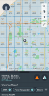
I have those apps; which are very helpful, but they do not show max height AGL for each section. For example, around an airport it would show 0', farther out, 200', then farther out it would be 400'. Cannot find this now. I have opened each of those apps and clicked on everything, but can not bring this up.
baristabob
Well-Known Member
Airmap does that for me. It is a grid of the altitudes.I have those apps; which are very helpful, but they do not show max height AGL for each section. For example, around an airport it would show 0', farther out, 200', then farther out it would be 400'. Cannot find this now. I have opened each of those apps and clicked on everything, but can not bring this up.
I have those apps; which are very helpful, but they do not show max height AGL for each section. For example, around an airport it would show 0', farther out, 200', then farther out it would be 400'. Cannot find this now. I have opened each of those apps and clicked on everything, but can not bring this up.
Here's the Visualize It website.
Not sure if there is an app. ?
ArcGIS Web Application
 www.arcgis.com
Tomk_
Well-Known Member
I have those apps; which are very helpful, but they do not show max height AGL for each section. For example, around an airport it would show 0', farther out, 200', then farther out it would be 400'. Cannot find this now. I have opened each of those apps and clicked on everything, but can not bring this up.
You sure seem to be describing Airmap
Yep.
From AIRMAP...Normal, IL USA.

CactusJackSlade
Well-Known Member
- Joined
- Oct 17, 2016
- Messages
- 1,087
- Reactions
- 846
Similar threads
- Replies
- 21
- Views
- 3K
- Replies
- 8
- Views
- 976
- Replies
- 44
- Views
- 2K
- Replies
- 0
- Views
- 588
DJI Drone Deals
1. Mini 2
2. Mini 3 Pro
3. Mini 4 Pro
4. Air 2s
5. Air 3
6. Avata 2
7. Mavic 3 Pro
8. Mavic 3 Classic
2. Mini 3 Pro
3. Mini 4 Pro
4. Air 2s
5. Air 3
6. Avata 2
7. Mavic 3 Pro
8. Mavic 3 Classic
New Threads
-
-
-
-
-
DJI Mini 4 "Aircraft Storage Full" (Code1C001COA) - clearing via Mac not fixing it
- Started by jorgie2u
- Replies: 2


