Hi
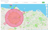
in Edinburgh and am reasonably new to drone flying so was wondering if someone could clarify something for me. I have the NATS app and am looking for places to practice flying. I am aware of the restrictions round airports obviously and notice that there are a number of areas and flight paths which are not permitted. My question is that I am in a very large circle outside the main airport one which extends all the way to Musselburgh in the east and Bo’ness in the west. Can I confirm if I am allowed to fly in this area at all? The app spays that it is restricted airspace but that I should take care when flying. Not that I can’t fly at all.
any help would be appreciated
cheers
james