DJI Mavic, Air and Mini Drones
Friendly, Helpful & Knowledgeable Community
Join Us Now

Flying drove over the Pacific - Is the entire Oregon Coast really off-limits?

Kmgcmk

New Member
Joined
Jun 7, 2022
Messages
4
Reactions
6
Age
60
Location
Oregon
I was hoping to take the drone to the coast this coming week to hopefully get some video of the whales migrating. I checked Aloft, and the entire Oregon coastline is off-limits. It says that it is a "wilderness area", and flights are prohibited. Am I missing something here, or is the entire coast of Oregon off-limits?

BTW, if I am allowed to fly, I plan on abiding by the same rules as boats, and stay at least 100 yds from any whales. I'll set my height at 300', and go no lower. I hope my Air 2S zoom is good enough to still get some good video.
 
Not at all true - the islands off the Oregon coast are off limits and all 1800 of them are part of the Oregon Islands National Wildlife Refuge which you need to avoid. There are a couple of Oregon State Parks that don't allow drones including the coast from the South Jetty at Coos Bay down to and including Bandon. Ecola State Park also is listed for no drone flights. The rest of the coastline is not restricted.
 
Not at all true - the islands off the Oregon coast are off limits and all 1800 of them are part of the Oregon Islands National Wildlife Refuge which you need to avoid. There are a couple of Oregon State Parks that don't allow drones including the coast from the South Jetty at Coos Bay down to and including Bandon. Ecola State Park also is listed for no drone flights. The rest of the coastline is not restricted.
Thanks Alan. I will use Google Earth to scope out any good launch points and avoid anything that can be mistaken for an island. I thought that was a bit restrictive, even for Oregon. Now if only I can get a day with little wind and no rain on the coast in the next few weeks.
 
  • Like
Reactions: R.Cowan and FlyingB
Thanks Alan. I will use Google Earth to scope out any good launch points and avoid anything that can be mistaken for an island. I thought that was a bit restrictive, even for Oregon. Now if only I can get a day with little wind and no rain on the coast in the next few weeks.
Little wind and no rain along the Oregon coast in late December? 🤣

That said I did get some time like that early in November with some high swells, no rain, and no wind which is a really rare combination. This is a shot of Thor's Well at Cape Perpetua shot with the 162mm lens on a Mavic 3. The swells were high enough that day so keep people away from the Well but on a day with lower surf make sure you stay away from the crowds that can gather out on the basalt.

 
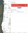
I am planning a "spring break" trip with visiting family in April, to show them the beautiful Oregon coast. Was hoping to fly the drone, but just yesterday, I took a look using Aloft, and ****, it shows literally every inch of the coast of Oregon, from the Columbia River to the California state line, is designated as a wilderness area, and is depicted as a no-fly zone. Every inch.

Really. It's ALL red. The entire coast. Look:

Oregon_Coats-NFZ.jpg

So while I would love to find that the following is true...

Not at all true - the islands off the Oregon coast are off limits and all 1800 of them are part of the Oregon Islands National Wildlife Refuge which you need to avoid. There are a couple of Oregon State Parks that don't allow drones including the coast from the South Jetty at Coos Bay down to and including Bandon. Ecola State Park also is listed for no drone flights. The rest of the coastline is not restricted.
...it would appear that Aloft/B4UFLY disagrees with you. And I've always assumed that B4UFLY is the authoritative source. No?

I'm wondering what's the basis for your statement, and why are you confident that Aloft is wrong about this?

To be clear: I would greatly prefer you to be right, but looking at the above, I can't help but be skeptical.

Discouraging, no?
 
  • Like
Reactions: Torque and R.Cowan
I am pulling the information directly from the FAA sectional maps and the information from the Fish and Wildlife Service web page. B4UFly is not an authoritative source. The FAA sectional maps are. The wilderness area off the Oregon coastline consists of just north of 1800 islands and 2 designated headland areas. According to the FAA maps the islands are the refuge areas and not the entire coast. Wilderness No Fly areas are well marked on the FAA sectional maps.

This wildlife area is quite different from the marine sanctuaries along the Olympic oast National Marine Sanctuary (inclusive of the whole coastline from Neah Bay down to just north of Copalis Beach) and the Greater Farallones Islands National Marine Sanctuary along the northern CA coastline. Both of those are inclusive of the whole coastline.
 
Last edited:
Hmm. I'm no stranger to the charts -- lifetime pilot, aircraft owner for decades. I fly around the NW coasts a lot (in my Cessna); hope to do so with my drone, too.

I have always assumed that FAA charts are an authoritative source for airspace restrictions for crewed aircraft, not necessarily for drones. Though I would hasten to add as both a private pilot and a part 107 drone pilot, that I'd assume any restrictions that apply to crewed aircraft also apply to drones. But I'm not sure that the reverse is always true: are there not airspace restrictions in place for drones that do not apply to crewed aircraft? Sure there are: National Parks, for example. I can fly over national parks in my Cessna (I do so often) but I can't fly my Mini 3 Pro over the same national park.

Are we just talking about the perennial issue of takeoff/landing (on a piece of ground) versus overflight?

BTW, I'm quite familiar with the National Marine Sanctuary along Washington's Olympic Coast - you can fly over it (in a crewed aircraft) but flying below 2000' AGL "violates NOAA regulations." Note that language (which is printed on the charts). I believe it was chosen carefully...flying below 2000' there does NOT violate FAA regulations (if it did, they would just say so). I know of some airplane owners who scoff at that 2000' minimum altitude restriction, claiming that NOAA has no jurisdiction over their crewed aircraft flight operations, and that's the reason why the exact language you see on the sectional charts was chosen (because the FAA did not want any part of sorting out complaints that some guy flew his plane over an offshore rock at 1500 feet and disturbed some birds). Note: I do not know if that's true (though it seems very plausible to me, having observed the ways of the FAA for the past 50 years); so I don't claim to know if NOAA has jurisdiction to fine or arrest me if they caught me flying over the Olympic NMS at less than 2000' in my Cessna (I'm pretty sure the FAA really does not care and has no desire to be party to any disputes over that). But I have no interest in being that test case. Before the Olympic NMS went into effect, I had flown over those areas at 1000', occasionally dropped down a bit lower to watch whales and other wildlife; the views were lovely, and I was 100% confident that no wildlife could hear me (little Cessna with a small engine really does not make much noise, even at low altitudes). But once that NMS "notice" started appearing on the maps, I have always kept to over 2000' when flying over those areas and will continue to do so.

I digress, but my point is: I believe the charts are primarily designed for crewed aircraft, and should not be considered to be an all-inclusive, comprehensive source for ALL restrictions on drone operations. That is, the charts are a very good starting point (and anything marked as restricted or prohibited should of course be respected), but they may not depict ALL locations where drones are restricted/prohibited.

OK, so back to Oregon...can you point me to the specific source of the FWS regs you would reference? I'm just looking for something a bit more definitive (no offense, disrespect or shade intended).

I note (with a quiet chuckle) that on the Aloft/B4UFLY page, where it says the entire Oregon Coast is a "FWS Wilderness Area" - "Drones are prohibited in all wilderness areas." Labeled as "Rule URL" it provides a link, but that link is NOT to a FWS or other government agency website. It's to something called "Wilderness Connect" which appears to be more of an advocacy organization (located on the University of Montana campus). Hmmmm. They may be great folks doing necessary work, but it does not appear (to me) at first glance that they have any authority to prohibit drone flight here ("here" = everywhere along the Oregon Coast).

Interesting issue. Thanks for all insights.
 
Good to know the starting point here for further discussion.

Here is the correct link for the Oregon Islands National Wildlife Refuge

Down towards the bottom of the menu on the left is an entry for Responsible Drone Use. The key for flying a drone along the Oregon Coast lies in the fact that the Wildlife Refuge boundaries are specific to the islands and not the waters around them. For the most part stay away from the islands and avoid disturbing the birds.

That opens up a lot of coastline that B4UFly flagged incorrectly. B4UFly does show that if you are launching from any turnout along US101 you are good to fly. There are numerous Oregon State Marine Sanctuaries along the coast but the only thing they care about for drones is that we aren't supposed to use them for fishing :)

Oregon State Parks doesn't have an official drone policy in place. Yet. They do say to check with your target park for more info. I do know that Ecola State Park, Arcadia Beach, Hug Point and all of the parks along the stretch from the south jetty at Coos Bay down to and including Bandon are off limits. As always this is a launch scenario since Oregon doesn't administer air.

That still leaves a lot of coastline to fly in and there is plenty of cool scenery to keep you entertained. This is one of my main playgrounds.
 
Last edited:
Awesome. Thank you. The link for the USFWS (and NOAA Fisheries) drone policies are great news, and yes, pretty clear. I can live within those regs easily.

It's also v-e-r-y interesting to note that B4UFly has got this, well...wrong. And not wrong in a small way. I wonder how many other things they get wrong. Hmmm and hmmm again. As a president once said, "fool me once..."

Anyway, for our "spring break" trip in April, we will be driving down from Seattle, and spending a few days following the coast down starting in Astoria and as far south as Reedsport, before turning inland. I know the area fairly well (been there many times, though it's been a while). Will be hoping for decent weather (but ready for it if it's wet and windy). If you have any favorite spots to fly (or places to watch out), I'd welcome any tips.

Thanks again.
 
My favorite part of the coastline starts around Cape Fowlweather and the Otter Crest Loop. Tricky launch points but some fun coastline to shoot. Past Newport look for Seal Beach. Some nice rocks and shoreline. Things get interesting again starting near Yachats and all the way down to Florence from there.
 
Odd coincidence, I'll be flying drones at the coast for a few days starting this weekend. It really isn't a problem since most of the Coast is open. Currently a few parks and all the islands/rocks along with some wildlife areas are closed to drones.

@AlanL "from the south jetty at Coos Bay down to and including Bandon are off limits." Can you point me to an authoritive source to the above? Cape Arago and the Seastacks in Bandon is closed to drones. I often fly @ Whiskey Run to Seven Devils and cannot find any restrictions along that stretch.

Cheers!

Each of the State parks has a FAQ on the and the ones that don't allow drones mention whether they do or not. This is from the FAQ for Bullard's Beach:

Screenshot 2022-12-21 at 6.38.38 AM.png

I have checked the FAQs for other parks along the coast and the others I found were mentioned in post #8 above.
 
BTW, I'm quite familiar with the National Marine Sanctuary along Washington's Olympic Coast - you can fly over it (in a crewed aircraft) but flying below 2000' AGL "violates NOAA regulations." Note that language (which is printed on the charts). I believe it was chosen carefully...flying below 2000' there does NOT violate FAA regulations (if it did, they would just say so). I know of some airplane owners who scoff at that 2000' minimum altitude restriction, claiming that NOAA has no jurisdiction over their crewed aircraft flight operations, and that's the reason why the exact language you see on the sectional charts was chosen (because the FAA did not want any part of sorting out complaints that some guy flew his plane over an offshore rock at 1500 feet and disturbed some birds). Note: I do not know if that's true (though it seems very plausible to me, having observed the ways of the FAA for the past 50 years); so I don't claim to know if NOAA has jurisdiction to fine or arrest me if they caught me flying over the Olympic NMS at less than 2000' in my Cessna (I'm pretty sure the FAA really does not care and has no desire to be party to any disputes over that). But I have no interest in being that test case. Before the Olympic NMS went into effect, I had flown over those areas at 1000', occasionally dropped down a bit lower to watch whales and other wildlife; the views were lovely, and I was 100% confident that no wildlife could hear me (little Cessna with a small engine really does not make much noise, even at low altitudes). But once that NMS "notice" started appearing on the maps, I have always kept to over 2000' when flying over those areas and will continue to do so.
NOAA has a special carveout for regulating airspace over the Marine Sanctuaries that is described in 15 CFR Part 922.

Glad NOAA is not administering the Oregon Islands :)
 
You can ignore most of that. It has been brought to the attention of Oregon department that did this.

We talked about this in a previous newscast.

Check it out here.

 
  • Like
Reactions: Torque and AlanL
You can ignore most of that. It has been brought to the attention of Oregon department that did this.

We talked about this in a previous newscast.

Check it out here.

Interesting to hear how B4UFly ended up with the coastal wilderness layer like what we see up near the top. Thanks for discussing this point.
 
Interesting to hear how B4UFly ended up with the coastal wilderness layer like what we see up near the top. Thanks for discussing this point.
Those who put the data on B4UFly don't double check it. It's been brought to the attention of the FAA. So far has not been addressed. We have the same issue for Jefferson County Open Space here in Colorado. They have listed a rule that you can't fly over it. They know better, but they haven't changed it on B4UFly. They haven't changed the wording on their rules on their website yet either.
 
There is a sign prohibiting drones in Cannon Beach,, but that is only in Cannon Beach. Many miles of coastline elsewhere.
 
Each of the State parks has a FAQ on the and the ones that don't allow drones mention whether they do or not. This is from the FAQ for Bullard's Beach:

View attachment 158552

I have checked the FAQs for other parks along the coast and the others I found were mentioned in post #8 above.
I knew that. What I was getting at is the statement that there is a restriction from Coos Bay south jetty down to Brandon. I can't find any restriction other than a few state parks. I drone that stretch often as there is no known restrictions.

Cheers!
 
…I digress, but my point is: I believe the charts are primarily designed for crewed aircraft, and should not be considered to be an all-inclusive, comprehensive source for ALL restrictions on drone operations. That is, the charts are a very good starting point (and anything marked as restricted or prohibited should of course be respected), but they may not depict ALL locations where drones are restricted/prohibited...
LAANC providers, B4UFly, and DJI FlySafe have many errors in their mapping; none of them should be considered the final authority. FAA’s aeronautical charts should be considered the primary source for airspace restrictions for crewed aircraft and drones. There is no more authoritative source.

Outside of airspace restrictions, “…locations where drones are restricted/prohibited…” are predicated on private property rights, various state/local privacy laws, and the rights of local governments to make rules for parks, streets, sidewalks, and other gov owned property A few jurisdictions, like Cannon Beach Oregon, consider drones a nuisance to be regulated anywhere inside the city limits.

All the above restrictions (that are not airspace) relate to where the pilot is operating… where you can launch, pilot, and land.

None of those property rights or laws, except FAA/DOD airspace restrictions and National Wildlife Refuges altitude minimums, affect airspace. On the other hand if a local LEO detains/cites/arrests(?) you for operating from outside the city limits but flying over eg. Cannon Beach it may be very inconvenient even if you’re in the right.
 
  • Like
Reactions: orionshooter
Lycus Tech Mavic Air 3 Case

DJI Drone Deals

New Threads

Forum statistics

Threads
130,989
Messages
1,558,680
Members
159,981
Latest member
bbj5143