DJI Mavic, Air and Mini Drones
Friendly, Helpful & Knowledgeable Community
Join Us Now

Flying within “red” zone about 3.5 miles

wvueagle

New Member
Joined
Dec 7, 2018
Messages
4
Reactions
1
Age
39
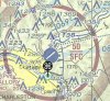
Looking if anyone has had experience with flying within about 3.5-4 miles of class c airspace - small regional airport. Kittyhawk app/maps referencing the LAANC shows 0 on the charts but across the river shows 400 AGL with authorization. However AirMap shows it in “yellow”. On the photo from the charts location is marked. Anyone been in similar situations? Are you indeed not at all able to fly in this space? Or up to the airport tower? Flying under recreational use not part 107
Thanks!
 

Attachments

  • E35E147F-DDB2-4A63-A70D-72F673C8D169.jpeg
    E35E147F-DDB2-4A63-A70D-72F673C8D169.jpeg
    1.3 MB · Views: 43
Last edited:
Under recreational rules you can fly you just need to notify the airport. Now whether or not DJI will let you fly is another story. If flying 107 then you have to get a LAANC authorization and if it says 0 then you can't fly without a waiver.
 
Last edited:
  • Like
Reactions: dawgpilot
Great thanks. So there are areas under 107 that you can’t fly but if flying recreational you can, with airport approval? Or is it simply notification? There is also a hospital helipad across the river, any concern there? Or is that under the airports airspace?
 
Yes the rules are different for commercial flights. Under hobbiest rules you just need to notify. You also need to notify the hospital where that heliport is.
 
  • Like
Reactions: dawgpilot
you have to ask for permission via the LAANC. usually requesting permission for SFC to 5000 is a little harder, because you have to prove to the FAA that your mission will be safe. also make you you are not going to be in the path of a traffic lane.
 
you have to ask for permission via the LAANC. usually requesting permission for SFC to 5000 is a little harder, because you have to prove to the FAA that your mission will be safe. also make you you are not going to be in the path of a traffic lane.

That's for Part 107 flights. Recreational users don't use LAANC at the moment. (instead they need to notify all airports within 5mi)
 
  • Like
Reactions: crlmjohnson
Correct
 
That's for Part 107 flights. Recreational users don't use LAANC at the moment. (instead they need to notify all airports within 5mi)
I live 3 miles from a local airport and am new to this. Do you need to call an airport every day if you fly every day? I can not fly over 400 feet, and the air craft can not fly under 1,000 feet in my area. Seems the airport manager would be annoyed having a call every day for the same thing. If once OKed would that not be sufficient?
 
I contacted my local airport today and the tower manager was very nice. Checked my address and told me my zone limits me to two hundred feet. I found that strange since aircraft can not fly below 1,000 feet over the residential area and everything I have read says stay under 400 feet. He agreed with me that calling everyday I fly would be annoying and said just abide by the rules, and to only call if the drone is lost in any way.
Not sure if the two hundred feet is correct, but if that's it, we just have to be be careful.
 
  • Like
Reactions: dawgpilot
You should be fine. I have been thru that same scenario with another airport in my area. same approval as you. 200' I was ok, with my approval, since it was high enough to clear the trees around the lake that I will be flying my drone. also the airport that i was flying around was a private/city, non-tower airport.

I was only looking for 100' from the airport.

The main thing is that the the tower manager agree to let you fly.
 
I contacted my local airport today and the tower manager was very nice. Checked my address and told me my zone limits me to two hundred feet. I found that strange since aircraft can not fly below 1,000 feet over the residential area and everything I have read says stay under 400 feet. He agreed with me that calling everyday I fly would be annoying and said just abide by the rules, and to only call if the drone is lost in any way.
Not sure if the two hundred feet is correct, but if that's it, we just have to be be careful.
To find out whether the 200 feet is correct, the map linked below shows the grids and ceilings around airports. You can enter your exact address into the search box in the upper left or play around with the map. The grids around the airports were developed by the management at each airport, not arbitrarily set. I had the opportunity to review the grids for two airports near me which have overlapping patterns. I found a couple of grids which had different ceilings, so the managers worked out a common ceiling before submitting their grids up the chain.
ArcGIS Web Application
 
I sent 2 letters to my local Heliports (Used for Lifeflight) and told them I would be flying in the area at times and that the letter served as notification. Sent it signature required. Got a call back from the Security Manager at the Heliport asking for a number that they could text me at if expecting a lifeflight.

Gave him the number and he wished me well. Other Heliport did not respond.

I have attached the draft that I used as a template when crafting my notiifcation letters. Feel free to use it with your own information.
 

Attachments

  • FAA Notification Go By.pdf
    36.8 KB · Views: 8
Lycus Tech Mavic Air 3 Case

DJI Drone Deals

New Threads

Forum statistics

Threads
131,073
Messages
1,559,545
Members
160,050
Latest member
invertedloser