DJI Mavic, Air and Mini Drones
Friendly, Helpful & Knowledgeable Community
Join Us Now

Great Places to fly in Northern California

Shon

Well-Known Member
Joined
Mar 8, 2019
Messages
306
Reactions
306
It seems like some folks have a challenge figuring out where they might legally fly their drones. Living in Sacramento, There are plenty of "legal" places to fly...but if I really want to capture some spectacular video...I have to travel a bit.

I thought I would share some of the more spectacular places I have found to fly. Feel free to share your own!

1. Phantom Falls:
This is a seasonal waterfall surrounded by incredible fields of wild flowers. The water fall dries up in the summer. Now is the time to hit this location. Here is a video I took last year: (Skip to about a minute into the video if you want to see better drone footage):
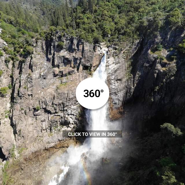
2. Bassi Falls:
This Waterfall is available year round. April to May is usually the best time to go for run-off:

3. Bodega Bay:
A great place to fly along the coast. Plenty of arches and rock formations along the ocean (skip to about 4:40 in this video to see Bodega Bay footage):

There are several other places that I haven't found time to get to as of yet.

Auburn State Recreation Area has some great canyons and features The Forresthill Bridge which has been a set piece for some huge Hollywood movies.

Feather Falls is one of the highest waterfalls in California, but less popular than others due to geographic location, and the 9.5 mile round trip hike. It looks like an excellent subject and I plan to get out there later this summer.
 
I live one hour due east of you and agree that there are a lot of cool places to fly and film. I’m curious if Phantom Falls will allow Mavics. Ha ha
 
  • Like
Reactions: Hauptmann
It’s important to research a place first before assuming it’s ok to fly there. Even hobby fliers should at least check the sectionals, or use free online resources like the Airmap app or VFRmap.com. These will show restricted areas based on federal regulations, but local laws should also be checked, especially when trying to fly in some of the places shown on the videos that are in state ecological reserves.

A lot of the places shown in the example videos are not ‘legal’ flying areas at all. Obvious probibited areas include Zion National Park and Bryce Canyon National Monument, but fewer people know that much of the central and northern California coast has a 2000 ft minimum AGL restriction as it is a Marine Sanctuary, Bodega Bay is an exception to this and is clear for flights. Also, Phantom Falls is in the North Table Mtn. Ecological Reserve, which restricts all aircraft from being operated from within its boundary, including drones.
 
Last edited:
It’s important to research a place first before assuming it’s ok to fly there. A lot of the places shown in the example videos are not ‘legal’ flying areas at all. Obvious probibited areas include Zion National Park and Bryce Canyon National Monument, but fewer people know that much of the central and northern California coast has a 2000 ft minimum AGL restriction as it is a Marine Sanctuary, Bodega Bay is an exception to this and is clear for flights. Also, Phantom Falls is in the North Table Mtn. Ecological Reserve, which restricts all aircraft from being operated from within its boundary, including drones.

I think you make some valid points. I really try and research all the locations I fly.

The example video you mentioned contained quite a bit of footage that was taken using a GoPro Hero 5 action camera and GoPro Karma gimbal and stablizer. It was not meant to showcase drone footage, but rather to share with family and friends many of the fun adventures we had in 2018. I only referenced a a specific point in the video that had to do with Bodega Bay.

I did NOT actually fly in any National Parks, and I have not encouraged anyone to do so. I consider it a complement that it was hard to tell the difference between the drone footage and non-drone footage. The effect is quite easy to achieve when using the same camera for both, but I’m pretty sure it will be harder to do with my Mavic Air.

Phantom Falls is actually on private propery, and you have to leave the ecological reserve to access it. AirMap shows the location ( including the ecological reserve) as clear, and I wasn’t able to find anything on their website to indicate that drone operation is prohibited.

As you mentioned Bodega Bay is clear... and I think AirMap does a good job of showing where it is legal and not legal to fly, at least along the coast.

Hey Shon, I liked your videos. Sorry, I wasn’t saying you were flying illegally, the gimbal mounted camera work on Angel’s Flight trail and other places in ZNP were very good. My main points were meant for those thinking of going to fly in those locations you pointed out - as it is a “great places to fly in No Cal” thread, it implies these are great places to fly...

Anyways, keep up the good work- I contemplated geting an Osmo to do similar shots, but a handheld M2P is a wonderful gimbal mounted camera as well. Also fun to use is a simple pole mounted camera- Ive used a 20-foot extending pole with my DSLR to get drone-like top view pics of blooming joshua trees legally in Joshua Tree National Park.
 
  • Like
Reactions: Hauptmann and Shon
Hey Shon, I liked your videos. Sorry, I wasn’t saying you were flying illegally, the gimbal mounted camera work on Angel’s Flight trail and other places in ZNP were very good. My main points were meant for those thinking of going to fly in those locations you pointed out - as it is a “great places to fly in No Cal” thread, it implies these are great places to fly...

Anyways, keep up the good work- I contemplated geting an Osmo to do similar shots, but a handheld M2P is a wonderful gimbal mounted camera as well. Also fun to use is a simple pole mounted camera- Ive used a 20-foot extending pole with my DSLR to get drone-like top view pics of blooming joshua trees legally in Joshua Tree National Park.

Yes, an extension pole works wonders. I forgot to mention that I use that too. I use tbe “GoPro El Grande” due to the bulky construction and the fact that I can mount my gimbal on there as well.

Here is an example from Calaveras Big Tree State Park. While it is legal to fly there, I decided due to multiple factors to use camera, gimbal and extension pole instead. I had a larger drone without collision sensors at the time... with the Mavic... I wouldn’t be as concerned:

 
Last edited:
Auburn State Recreation Area

This state park allows drone flights. Features include the Forest Hill Bridge ( featured in some major Hollywood films), deep canyons With flowing river rapids, and lake Clementine Dam, that has a large flow of water cascading down the front, like a waterfall. Biking, hiking, horseback riding are all common methods for getting around.

I would warn that I have occasionally seen low altitude helicopter flights. There are also raptors and the occasional power line to be aware of.
 
  • Like
Reactions: AMann
Auburn State Recreation Area

This state park allows drone flights. Features include the Forest Hill Bridge ( featured in some major Hollywood films), deep canyons With flowing river rapids, and lake Clementine Dam, that has a large flow of water cascading down the front, like a waterfall. Biking, hiking, horseback riding are all common methods for getting around.

I would warn that I have occasionally seen low altitude helicopter flights. There are also raptors and the occasional power line to be aware of.

The SRA’s (State Rec Areas) are a good bet, they let green sticker vehicles in too. Hope they don’t start charging for drones, too.
 
  • Like
Reactions: Shon
I tried to fly at Phantom Falls today, but ran into too much trouble:
1. My phone was unexpectedly dead after hiking several miles to the spot I planned to launch from. It was 100% When I started...must have been on in my pocket or something... :(
2. Two Hawks were circling the area. No big deal...got to charge my phone battery anyway.
3. Phone Battery charged...oh wait...now a couple of paramotor pilots show up to have some fun. Maybe they will scare away the hawks?
4. Paramotor pilots gone. Hawks gone... time to fly my drone!
5. Wait...the hawks are back...they are circling above me...are they going to attack from the angle of the Sun?
6. NO! it's not the hawks I have to worry about...a sparrow is attacking my drone! It thinks my Mavic Air is some tasty insects! Abort...Abort!
7. I have to go! I have an afternoon appointment...maybe squeeze in one more flight? Wait? Is that a bi-plane? :oops:
 
  • Haha
Reactions: pelagic_one
Got out to Bassi Falls over the weekend. Great place to fly in the El Dorado National Forest.

This weekend I’m headed north to Feather Falls. It’s one of the tallest waterfalls in California. It is quite spectacular and not as heavily visited as Yosemite. Oh, and it is legal to fly there. :)
 
Hi,
What are you using to produce the 370VR’s? Also, are you manually controlling the shots, or using pano mode?
 
Hi,
What are you using to produce the 370VR’s? Also, are you manually controlling the shots, or using pano mode?

Using 360 Pano setting. It is hit and miss in terms of results. This time I saved some of the raw photos so I plan on going back and stitching them myself to see if manual stitching will be an improvement.
 
  • Like
Reactions: AMann
Nice shots. Wonder if you have shot near Shasta or Lassen before? Not within the national park, but in the national forest. Any good recommendations from those who have been?
Have a couple days down there coming up and would love to get some shots!
 
Lycus Tech Mavic Air 3 Case

DJI Drone Deals

New Threads

Members online

Forum statistics

Threads
130,978
Messages
1,558,527
Members
159,967
Latest member
rapidair