

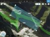
I’m going to be hiking and flying a mission in the Rocky Mountains in a couple days and am wondering what gs pro is going to do for altitudes? In the newest version it shoes various altitudes now in the flight plan as you can see in the screenshot. I know that it uses take off altitude as your base alititude but is gs pro going to do varying terrain or do a flat grid flight? If it does a flat grid flight then I’m worried about it running into the side of the mountain. Thoughts or suggestions? We can hike up to higher point and launch it so it’ll clear all terrain but then the lower valley will be less resolution.

GS Pro Varying elevation?
- Thread starter Darryl
- Start date
-
- Tags
- gs pro mavic 2 pro
Similar threads


DJI Drone Deals
1. Mini 2
2. Mini 3 Pro
3. Mini 4 Pro
4. Air 2s
5. Air 3
6. Avata 2
7. Mavic 3 Pro
8. Mavic 3 Classic
2. Mini 3 Pro
3. Mini 4 Pro
4. Air 2s
5. Air 3
6. Avata 2
7. Mavic 3 Pro
8. Mavic 3 Classic
New Threads
-
Air 3 Gandia ( Spain ) RH Hotel Study and Gandia Beach
- Started by Pacefast
- Replies: 0
-

-
-

-