DJI Mavic, Air and Mini Drones
Friendly, Helpful & Knowledgeable Community
Join Us Now

Hasselblad camera specs calculation of footprint

Deepwater

Active Member
Joined
Oct 30, 2018
Messages
40
Reactions
7
Age
72
What is the footprint sides (Length x Width) when I take a photo and video at 100-m elevation with the camera pointing straight down at 90-deg. with my Mavic 2 Pro with Hasselblad camera?

Would like to see the calculation.
 
The camera has a 77 degree field of view (approx).
 
AoV on the M2P is given by DJI as approx 77deg., so to solve:

  • Take one side of the triangle formed by the Horizontal FoV.
  • You now have a 100m tall right angled triangle with the 90deg. angle at the base and an angle to the hypoteneuse of 77/2 deg. at the top.
  • The length of the opposite side to that angle is the sine of the angle, or sin 38.5, which gives 79.5m .
  • Double it to get the full axis, and you get a horizontal axis length of approx 159m.

  • Aspect ratio on the M2P is 3:2, so 159/3*2 gives a vertical axis of approx 106m.

Note that the M2P records altitude AGL from the point of take off, not at its current location, so if you're planning on using this to measure stuff and your not operating over the ocean or a very flat landscape you're going to have a margin of error. Ideally, you'd want a photograph at your operating AGL of something that you can scale off as a double-check if you're doing anything that matters.
 
Thanks for feedback.

Is field of view the same in X and Y?
No .. it's not.
FoV angles are usually given as the diagonal (largest) angle.
It could only be the same in X & Y if the image was square.
 
Last edited:
What is the footprint sides (Length x Width) when I take a photo and video at 100-m elevation with the camera pointing straight down at 90-deg. with my Mavic 2 Pro with Hasselblad camera?
At 100 metres above ground the lens would be covering an area approx 129 metres x 96 metres.
 
Last edited:
  • Like
Reactions: GadgetGuy
Thanks for all your feedback.
For those of you who are interested, here is a reply from DJI:

Good day!
Our engineers have replied, below is the provided information by our engineers for your query.
FOV = 77°
(X)HFOV = 64.94°
(Y)VFOV = 51.03°
Kindly let me know if you need further assistance. Thank you again for your time.
Thank you for choosing DJI!

The above gives me the following FOV:
1570738308273.png
 
  • Like
Reactions: Hitchy
You could take pictures hovering 100 m above an unoccupied sports field that has known dimensions to confirm.
 
  • Like
Reactions: Hitchy
Thanks for all your feedback.
For those of you who are interested, here is a reply from DJI:

Good day!
Our engineers have replied, below is the provided information by our engineers for your query.
FOV = 77°
(X)HFOV = 64.94°
(Y)VFOV = 51.03°
Kindly let me know if you need further assistance. Thank you again for your time.
Thank you for choosing DJI!

The above gives me the following FOV:
View attachment 83339
Won’t you have to figure in wide angle lens distortion too though making it extremely difficult to get an accurate calculation particularly the further you are from the ground with a single photo?

0EE824C4-D7F5-4770-BDB3-F0F19DF38F3C.jpeg
 
  • Like
Reactions: Hitchy
Additional error is displayed height can drift. You can see this when you fly back to launch point. You'll note height won't be zero. I often find it drifts in the negative.
 
You could take pictures hovering 100 m above an unoccupied sports field that has known dimensions to confirm.
Won’t you have to figure in wide angle lens distortion too though making it extremely difficult to get an accurate calculation particularly the further you are from the ground with a single photo?

View attachment 83340
Thanks for your great comment. I wish I knew more about camera lens engineering. The FOVs I received from DJI will help me tremendously since I am taking pictures of a couple of hundred properties with the camera at -90deg. using Litchi, witch is a great application by the way. I do not think distortion is an issue. This is from past photo taking. I think the issues would be different if I had the DJI zoom.
 
Thanks for your great comment. I wish I knew more about camera lens engineering. The FOVs I received from DJI will help me tremendously since I am taking pictures of a couple of hundred properties with the camera at -90deg. using Litchi, witch is a great application by the way. I do not think distortion is an issue. This is from past photo taking. I think the issues would be different if I had the DJI zoom.
Distortion is not an issue because it's corrected.
I'm not sure why you'd really need to know the dimensions of the area covered at various heights.
If the properties are small enough, you simply fly up till you have the whole area covered.
If the properties are too big, you use the proper tool for the job.
That tool id to use a mapping app to produce orthophoto composite images made from overlapping images.
As an example, here's an orthophoto of 120 acre site, rendered from 380 individual images.
8623_Sancus%20ortho_sm-X3.jpg
 
  • Like
Reactions: KIT72 and GadgetGuy
Thanks for your great comment. I wish I knew more about camera lens engineering. The FOVs I received from DJI will help me tremendously since I am taking pictures of a couple of hundred properties with the camera at -90deg. using Litchi, witch is a great application by the way. I do not think distortion is an issue. This is from past photo taking. I think the issues would be different if I had the DJI zoom.
I just re-read your original post and originally I thought you were trying to measure an actual footprint from 100m up hence my first post about big foot ?.

At any rate it depends on how accurate you need the measurements. @Meta4 is correct that the jpeg photos are corrected but this means the image is manipulated to correct the issue so I don’t know how that affects the calculations honestly. As @Meta4 said as well here are proper tools to do this
 
  • Like
Reactions: GadgetGuy
Distortion is not an issue because it's corrected.
I'm not sure why you'd really need to know the dimensions of the area covered at various heights.
If the properties are small enough, you simply fly up till you have the whole area covered.
If the properties are too big, you use the proper tool for the job.
That tool id to use a mapping app to produce orthophoto composite images made from overlapping images.
As an example, here's an orthophoto of 120 acre site, rendered from 380 individual images.
8623_Sancus%20ortho_sm-X3.jpg
You are correct. However, I have a different application. Developing 250 real estate properties. Will fly several Litchi plans and take photo of each property with camera at -90deg., heading North (0) and pre-program the Mavic 2 Pro altitude so I can get each property in the FOV. Elevation difference is appr. 150-m. Since I know the individual property sizes, I can, therefore, pre-program the elevations in Litchi using calculations from EXCEL CSV format imported to Litchi. Pretty neat what you can do.
 
  • Like
Reactions: GadgetGuy
Something else to consider is video is cropped to 16:9 so has a smaller FoV than photos. So you need to be higher.
Apps like Photopills are very useful for planning where and how high you need to be for a specific shot.
 
Something else to consider is video is cropped to 16:9 so has a smaller FoV than photos. So you need to be higher.
Apps like Photopills are very useful for planning where and how high you need to be for a specific shot.
Thanks a lot. I have Photopills, but never used it yet. Need to sit down and understand the application. Any good advise?
 
Thanks for all your feedback.
For those of you who are interested, here is a reply from DJI:

Good day!
Our engineers have replied, below is the provided information by our engineers for your query.
FOV = 77°
(X)HFOV = 64.94°
(Y)VFOV = 51.03°
Kindly let me know if you need further assistance. Thank you again for your time.
Thank you for choosing DJI!

The above gives me the following FOV:
View attachment 83339
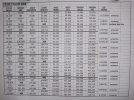
I used these numbers and calculated in feet and have on a similar sheet. Tried to upload from Excel but this forum format doesn't like that type of file so here is a pic of the file. thumbnail[1] (4).jpg
 
Last edited:
  • Like
Reactions: GadgetGuy
Thanks for all your feedback.
For those of you who are interested, here is a reply from DJI:

Good day!
Our engineers have replied, below is the provided information by our engineers for your query.
FOV = 77°
(X)HFOV = 64.94°
(Y)VFOV = 51.03°
Kindly let me know if you need further assistance. Thank you again for your time.
Thank you for choosing DJI!

The above gives me the following FOV:
View attachment 83339
DRONE FIELD OF VIEW 4 30 2021.jpg
 
Distortion is not an issue because it's corrected.
I'm not sure why you'd really need to know the dimensions of the area covered at various heights.
If the properties are small enough, you simply fly up till you have the whole area covered.
If the properties are too big, you use the proper tool for the job.
That tool id to use a mapping app to produce orthophoto composite images made from overlapping images.
As an example, here's an orthophoto of 120 acre site, rendered from 380 individual images.
8623_Sancus%20ortho_sm-X3.jpg
What software or app created this?
 
Lycus Tech Mavic Air 3 Case

DJI Drone Deals

New Threads

Forum statistics

Threads
131,096
Messages
1,559,795
Members
160,077
Latest member
svdroneshots