DJI Mavic, Air and Mini Drones
Friendly, Helpful & Knowledgeable Community
Join Us Now

HELP! Lost M2E Dual on 10-10-2022. Rain is on the way!

seanp.is

Member
Joined
Oct 13, 2022
Messages
7
Reactions
0
Age
51
Location
Rehoboth Beach, DE, USA
I have very little time left before the weather turns for the worse. If there is anyone or more persons who can help, I would be eternally grateful.

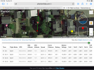
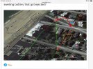
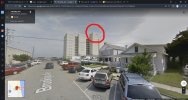
Also......here is a better image, attached, in .pdf format , of the flight. Last heading was approximately SSW and the last data packet received places the drone next to a high-rise condominium building which has multiple cellular towers. I forgot.
 

Attachments

  • October 10, 2022 04_50PM _ General _ Notifications _ DJI GO log 1.1.5 _ United States _ Airdat...pdf
    352.5 KB · Views: 40
  • October-10-2022-04-50PM-Flight-Airdata.zip
    1.7 MB · Views: 18
  • 20221011_202630.pdf
    3.5 MB · Views: 16
Last edited:
Sorry I can't help you with your flight analysis, maybe @Meta4 or @slup will show up soon to help you with that.

I can tell you though that a proper analysis will require the actual .txt log from your flight device... not a .pdf or .zip
 
i did...they are in excel and csv format
The flight data file from your device ends in .TXT, not PDF or CSV. It's the same txt file you would upload to AirData to do an analysis your self.
 
The flight data file from your device ends in .TXT, not PDF or CSV. It's the same txt file you would upload to AirData to do an analysis your self.
Ok...I have the.txt filez as well. Let me upload them. By the by...when u initially attempted to upload the flight data, which was in .txt format, AirData would not accept it. AirData oy accepted the flight data file that I uploaded afterwards. The .csv and excel files I uploaded to this forum are the results, from AirData.com, in the .csv and excel format.
Give me 5 minutes...I have been outside doing a hard target search.

....And thank you all for helping
 
My first time using phantom help,i hope i am reading this right but it seems like it landed somewhere between brooklyn ave and funland……move bar from left to right to see whole flight

 
Looks like this
 

Attachments

  • 35CB835F-DAFA-4EB3-A2DD-780EEF5326D1.png
    35CB835F-DAFA-4EB3-A2DD-780EEF5326D1.png
    2.8 MB · Views: 30
You bashed that M2E pretty well in Sport & during the flight several cells in the battery had a serious voltage sag down to levels equal 0%... that battery didn't look perfectly healthy.

In the last row in the flight your M2E was up on 254,6ft above the HP & was flying with a heading speed of 34mph with you applying full elevator command ... exactly there all goes dark & the log reports that the motors is off.

So your M2E most probably started to fall as a rock in compass direction 179.8 degrees from North, initially with a speed of 34mph but quickly slowing down due to drag,

Your M2E is most probably found somewhere from the marked last known location (red pin) close along the red line (direction 179,8 degrees)... & most probably in more than one piece.

The reason for this is most likely due to a sudden power loss ... swelling battery that got ejected?

1665690150347.png
 
Holy crap....yeah, let me go check. I'll be back within the hour. I'm just a five minute walk away...
Will probably not be easy to find the corpse, the M2E wouldn't have just fallen straight down ... it continued forward whilst slowing down & falling, eventually ending up somewhere closer to that drawn red line, it can easily have ended up on any of the house roofs seen there on the sat.pic.
 
Projectile motion calculator shows up to 196feet of falling distance,considering shape of M2E ,it is probably less than that …
 

Attachments

  • D7028552-C39B-460F-8D3E-1481F49D2ADD.jpeg
    D7028552-C39B-460F-8D3E-1481F49D2ADD.jpeg
    528.3 KB · Views: 28
Last edited:
Still searching....I happen to live just two blocks away from the calculated wreckage area. If you look at the map image, there is a high rise condominium between Brooklyn Ave. and Laurel St, named Star of the Sea, which is ocean front on the boardwalk and has multiple cellular towers installed on the roof facing West (see attached image). Google maps 3D has a fairly clear image of the cellular towers installed on the building.
Is there any possibility the cell towers could have played a role in the sudden loss of signal with the drone? Moreover, could the drone have kept flying without reconnecting with the RC?
 

Attachments

  • Screenshot 2022-10-15 080235_cell towers.jpg
    Screenshot 2022-10-15 080235_cell towers.jpg
    925.5 KB · Views: 13
...Is there any possibility the cell towers could have played a role in the sudden loss of signal with the drone?
No... if the control signal gets interfered it usually gradually gets degraded, not just cuts out in a tenth of a second. Besides that, if you had lost the connection with your drone it had failsafed to your set RTH, & nothing was in the way back to the HP & no strong wind preventing it & enough battery %, so it would had made it back.

Moreover, could the drone have kept flying without reconnecting with the RC?
No... the log clearly registered motors off in the end of the log.

What you saw was most probably a sudden power loss due to a ejected unhealthy battery as it probably swelled due to a excessive heat buildup during your Sport mode flying (both the large voltage drops & big cell deviations indicates that). When the drone lose power the control signal & the motors stop.
 

DJI Drone Deals

New Threads

Forum statistics

Threads
131,006
Messages
1,558,809
Members
159,988
Latest member
Allezzov