So after 200 flights and 1,000,000+ feet flown the inevitable happened - the M2P suffered a fatal crash this evening.
Replacement is on the way but I’m very curious to find out what happened and how to prevent this from happening in the future. I know there are some all-star black box diagnositicians on the board so curious to here your analysis.
Currently reading up on how to pull flight data from the app / drone... but here’s the play by play.
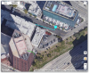
1) Take off was from a sidewalk, M2P initialized, initial compass error. Fixed after calibrating.
2) GPS took some time but did initialize and recorded the home point.
3) Take off, hover to 30-40 feet, quick joystick to the right to clear trees above.
4) Suddenly, M2P starts flying backwards, uncontrollably, full speed, veers right, and slams directly into a building wall. Dead on impact.
Note: the compass error was present upon initial boot up. I’ve seen the compass error many times before, but never experienced anything like this obviously.
I’m aware of magnetic interference coming from tall buildings or buildings in general. But have flown successfully many times when taking off from a sidewalk near tall buildings.
All collision systems on the M2P were active.
Anyhow, look forward to diagnosing.
I’m thinking compass error caused it to veer uncontrollably. No input on the control could save it.
Replacement is on the way but I’m very curious to find out what happened and how to prevent this from happening in the future. I know there are some all-star black box diagnositicians on the board so curious to here your analysis.
Currently reading up on how to pull flight data from the app / drone... but here’s the play by play.
1) Take off was from a sidewalk, M2P initialized, initial compass error. Fixed after calibrating.
2) GPS took some time but did initialize and recorded the home point.
3) Take off, hover to 30-40 feet, quick joystick to the right to clear trees above.
4) Suddenly, M2P starts flying backwards, uncontrollably, full speed, veers right, and slams directly into a building wall. Dead on impact.
Note: the compass error was present upon initial boot up. I’ve seen the compass error many times before, but never experienced anything like this obviously.
I’m aware of magnetic interference coming from tall buildings or buildings in general. But have flown successfully many times when taking off from a sidewalk near tall buildings.
All collision systems on the M2P were active.
Anyhow, look forward to diagnosing.
I’m thinking compass error caused it to veer uncontrollably. No input on the control could save it.
Last edited: