- Joined
- Feb 3, 2017
- Messages
- 20
- Reactions
- 9
- Age
- 54
Hi Everyone,
I have been searching high and low for something to explain this and give me an answer as to if we are or are not permitted to fly in this airspace (and why LAANC isn't available), but I just cannot get a clear answer and really not understanding why there is no LAANC authorization available for this area.
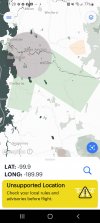
Here is the map from B4uFly (ignore the "unsupported location" error in yellow...I turned off my GPS so you won't know my exact location ):
):

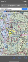
The grey circle, obviously, is an airport radius. Now, this area is defined as controlled airspace, naturally, and is designated a CLASS C airspace. No problem....LAANC authorization works flawlessly in this area, ranging from about 100ft to 400ft depending on how close your radius is to the airport.... B4UFLY lets you "Get LAANC" authorization by opening the Aloft Air Control app....I've done this numerous times and works just fine.
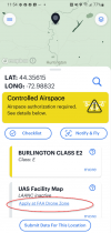
Now the absolute confusion. The light green rectangles are obviously the runway path directions and are also controlled airspace because of airline flight paths...just like the gray circle. HOWEVER, these light green areas are designated as CLASS E2 airspace. This is also controlled airspace, but a major difference is there is NO LAANC authorization available for these areas.
I am completely bewildered why you can be in the gray area (within 5 miles of the airport), directly inline with these light green rectangles and have no trouble getting LAANC authorization, yet moving further out away from the airport into the light green rectangles, all of a sudden you cannot get LAANC authorization.
Can anyone explain this to me? Typically, class E airspace is 700ft and above and we should be fine under 400ft, but I know E2 classification is a bit different, but I don't understand why it is so much more complicated to get approval for these light green areas than the gray circle around the airport itself?...they actually have a link in the Aloft app to apply at FAA drone zone for permission...WHAT?!

I have been searching high and low for something to explain this and give me an answer as to if we are or are not permitted to fly in this airspace (and why LAANC isn't available), but I just cannot get a clear answer and really not understanding why there is no LAANC authorization available for this area.
Here is the map from B4uFly (ignore the "unsupported location" error in yellow...I turned off my GPS so you won't know my exact location

The grey circle, obviously, is an airport radius. Now, this area is defined as controlled airspace, naturally, and is designated a CLASS C airspace. No problem....LAANC authorization works flawlessly in this area, ranging from about 100ft to 400ft depending on how close your radius is to the airport.... B4UFLY lets you "Get LAANC" authorization by opening the Aloft Air Control app....I've done this numerous times and works just fine.
Now the absolute confusion. The light green rectangles are obviously the runway path directions and are also controlled airspace because of airline flight paths...just like the gray circle. HOWEVER, these light green areas are designated as CLASS E2 airspace. This is also controlled airspace, but a major difference is there is NO LAANC authorization available for these areas.
I am completely bewildered why you can be in the gray area (within 5 miles of the airport), directly inline with these light green rectangles and have no trouble getting LAANC authorization, yet moving further out away from the airport into the light green rectangles, all of a sudden you cannot get LAANC authorization.
Can anyone explain this to me? Typically, class E airspace is 700ft and above and we should be fine under 400ft, but I know E2 classification is a bit different, but I don't understand why it is so much more complicated to get approval for these light green areas than the gray circle around the airport itself?...they actually have a link in the Aloft app to apply at FAA drone zone for permission...WHAT?!

Last edited:


