DJI Mavic, Air and Mini Drones
Friendly, Helpful & Knowledgeable Community
Join Us Now

How to fly to GPS coordinates?

OliveViewImages

Well-Known Member
Joined
Mar 17, 2020
Messages
45
Reactions
24
Age
66
Location
Millbrook, New York
Hi all,
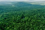
I recently took an aerial shot of a cabin in the woods with my Mavic 2 Pro (photo attached). I would like to take that exact same photo in spring, winter and fall. I have the GPS coordinates for the photo from the information stored with the photo. Is there a way to "instruct" my drone to fly to that exact same location so I can get the same image in the different seasons? Thank you!
Mike
 

Attachments

  • 1F636D6F-287F-40D7-ADA9-A485E16C17C7_1_201_a.jpeg
    1F636D6F-287F-40D7-ADA9-A485E16C17C7_1_201_a.jpeg
    9.5 MB · Views: 29
  • Like
Reactions: RMS001
In Litchi, I assume, instead of just plotting way points on a map, they also have the option of creating waypoint via GPS coordinates? Is this assumption correct


One of the wonders of Litchi is that you can pre-program missions and test fly them virtually on your computer. They can be saved for future as well as duplicate use. It is very handy in that regard. As per the image below, when you click on a waypoint it shows the GPS coordinates. You can just open the mission hub, click anywhere to start and modify it by typing in the coordinates (bottom image).

The thing that confuses me with coordinates is converting decimal degrees into minutes and seconds or vice versa. You can see that in the first image the coordinates are shown in decimal degrees while the coordinates in Google Earth are shown in minutes and seconds. This conversion may or may not be important depending on how you need to use the coordinates. In addition to programming missions, if you need a waiver from the FAA they require minutes and seconds, but sometimes the easy coordinate information is in decimals as shown in the first image.


1627664193720.png

1627664113261.png
 

Attachments

  • 1627663585179.png
    1627663585179.png
    6.5 MB · Views: 11
One of the wonders of Litchi is that you can pre-program missions and test fly them virtually on your computer. They can be saved for future as well as duplicate use. It is very handy in that regard. As per the image below, when you click on a waypoint it shows the GPS coordinates. You can just open the mission hub, click anywhere to start and modify it by typing in the coordinates (bottom image).

The thing that confuses me with coordinates is converting decimal degrees into minutes and seconds or vice versa. You can see that in the first image the coordinates are shown in decimal degrees while the coordinates in Google Earth are shown in minutes and seconds. This conversion may or may not be important depending on how you need to use the coordinates. In addition to programming missions, if you need a waiver from the FAA they require minutes and seconds, but sometimes the easy coordinate information is in decimals as shown in the first image.


View attachment 132598

View attachment 132597
Litchi only works in decimal degrees, but you can choose the coordinate format in Google Earth from either decimal degrees, degrees:decimal minutes, or degrees:minutes:decimal seconds. In the desktop version you can also use UTM.
 
Litchi only works in decimal degrees, but you can choose the coordinate format in Google Earth from either decimal degrees, degrees:decimal minutes, or degrees:minutes:decimal seconds. In the desktop version you can also use UTM.
Thanks. That was helpful. I didn't know you could change the settings. I think it will be a fast way to convert coordinates for FAA waivers in the future rather than trying to go through a conversion app or website.

How does UTM work and how is it different from standard coordinates?
 
Thanks. That was helpful. I didn't know you could change the settings. I think it will be a fast way to convert coordinates for FAA waivers in the future rather than trying to go through a conversion app or website.

How does UTM work and how is it different from standard coordinates?
UTM (Universal Transverse Mercator) projects a rectilinear grid onto the surface of the earth. Its advantage is that the resulting grid is square and measured in meters east and north, and so works well with map interpolators. Its disadvantage is that it obviously cannot consistently line up with true north, and so it has to be divided up into longitudinal zones, and even within those it deviates from north. Unlike lat/long, it also varies significantly with the projection datum used, so NAD27 gives different results than NAD83/WGS84, for example. It is primarily used for local operations like search and rescue, although with the ongoing transition to digital mapping systems, even in the field, it is becoming less necessary.
 
  • Like
Reactions: vindibona1
A simple waypoint mission in Litchi is probably the easiest way to achieve that.
I've been reading up on Litchi and watching a number of YouTu be videos. It seems like a good supplement to the DJI GO 4 app, which does a pretty good job with waypoints. But most of the videos are somewhat dated now. What I like about Litchi is the mission hub feature and the fact that I can use Litchi for waypoints on my backup Mavic Air (ver 1). I have a question, though....there are alot of complaints about Litchi, specifically that the developers have "dropped the ball" with communications, updates, etc. I'm willing to pay the $23 to get the app, but do you think in 2021 it's still worth it? I'm thinking the mission hub feature alone is worth getting the app for. Thanks!
Mike
 
I have a question, though....there are alot of complaints about Litchi, specifically that the developers have "dropped the ball" with communications, updates, etc. I'm willing to pay the $23 to get the app, but do you think in 2021 it's still worth it? I'm thinking the mission hub feature alone is worth getting the app for. Thanks!
Sure! Litchi is 'still relevant' in 2021... still just as useful, powerful and downright FUN to play with as always.

I've never had to communicate with their dev team, and don't put much value in updates to some apps (the 'improvements' are sometimes not an improvement at all... "if it's working, don't fix it"). And I always backup the current version of any app I might want to update, so I can revert if I don't like the new version.

If you get into Litchi, you should also check out a computer program named Virtual Litchi Mission (aka VLM)... with that you can virtually fly the mission in Google Earth. Also, Google Earth Pro is the way to go.

Good Luck
 
I've been reading up on Litchi and watching a number of YouTu be videos. It seems like a good supplement to the DJI GO 4 app, which does a pretty good job with waypoints. But most of the videos are somewhat dated now. What I like about Litchi is the mission hub feature and the fact that I can use Litchi for waypoints on my backup Mavic Air (ver 1). I have a question, though....there are alot of complaints about Litchi, specifically that the developers have "dropped the ball" with communications, updates, etc. I'm willing to pay the $23 to get the app, but do you think in 2021 it's still worth it? I'm thinking the mission hub feature alone is worth getting the app for. Thanks!
Mike
Perhaps you don't know, but one of the things about planning missions in the Mission Hub is that you can export the missions as a "KML" file which you can "fly" your mission virtually in Google Earth Pro right from your desktop. This feature itself makes owning the program incredibly valuable. Below is a screen shot from a virtual mission of the Chicago River and a second screen shot of the mission that was planned on the computer. I haven't flown it yet but hope to soon.

Now, you tell me if it's worth $23?

1628000548350.png


1628000630353.png
 
Most definitely!

(can one fly a drone in downtown Chicago? :) )
Absolutely. The city itself is pretty much open if you follow the standard UAV guidelines. Flying recreationally is no problem. Flying commercially may produce a few more hurdles. Just don't fly over people or do stupid stuff and there shouldn't be a problem. The Chicago ordinance, the only one in the state that can make it's own rules is a little vague and a bit open to interpretation. If you fly recreationally, stay away from private property, don't fly over people (I would guess now other than transitionally) you're on pretty good footing. Obviously there are those who will harass you as if you have an AR-15 slung over your shoulder. But that's a different discussion.
 
  • Like
Reactions: umanbean
Thanks for the replies - much appreciated!

Yesterday I played around with the mission hub and created two missions for upcoming jobs related to my original posting. Both are in heavily forested areas, so I uploaded the klm files to google earth pro to check the elevations and make sure I wouldn't be hitting any obstacles. So, yeah, that feature coupled with the ability to plan a mission on my computer makes it definitely worth the cost of the app, and I think I'll go ahead and get it. I'll also check out the VLM software. I guess I've been so comfortable with DJI GO 4 the past few years, I just needed some "encouragement!" ;-)
You're going to need the download for Litchi Virtual Missions in addition to Google Earth Pro. Here is the link:
LVM download link

Luckily Litchi is pretty easy to learn and I recommend you watch a few of the tutorial videos to get started. But there is a lot packed into the program, including FPV with VR goggles. The hour you spend watching tutorials will be well spent.

Good luck.
 
  • Like
Reactions: umanbean
You're going to need the download for Litchi Virtual Missions in addition to Google Earth Pro. Here is the link:
LVM download link

Luckily Litchi is pretty easy to learn and I recommend you watch a few of the tutorial videos to get started. But there is a lot packed into the program, including FPV with VR goggles. The hour you spend watching tutorials will be well spent.

Thank you! I've watched quite a few videos already and you're right, it was time well spent.

I can't use the link because I have a Mac, not a Windows PC. BUT, I was able to add the VLM extension to Google Chrome. Then, it's a simple case of exporting the mission from the hub as a VLM file. When I click on that file it opens it right up in Google Earth Pro. WOW! I'm impressed. I can already see that I need to drop my elevations a bit and widen my perimeter around the POI to get the kind of shots I'm going to want.
Mike
 
  • Like
Reactions: umanbean
Thanks for the replies - much appreciated!

Yesterday I played around with the mission hub and created two missions for upcoming jobs related to my original posting. Both are in heavily forested areas, so I uploaded the klm files to google earth pro to check the elevations and make sure I wouldn't be hitting any obstacles. So, yeah, that feature coupled with the ability to plan a mission on my computer makes it definitely worth the cost of the app, and I think I'll go ahead and get it. I'll also check out the VLM software. I guess I've been so comfortable with DJI GO 4 the past few years, I just needed some "encouragement!" ;-)
Try creating your missions in Google Earth and then import them to litchi and fine tune it there
 
Try creating your missions in Google Earth and then import them to litchi and fine tune it there
Thanks, I'll do that. I see that you can even add a number of cameras from DJI drones. Excellent stuff!
 
Thanks, I'll do that. I see that you can even add a number of cameras from DJI drones. Excellent stuff

Thanks, I'll do that. I see that you can even add a number of cameras from DJI drones. Excellent stuff!
If you have not seen this video here it is it walks you step-by-step on how to frame your shots save them and import them to litchi
 
  • Like
Reactions: umanbean
If you have not seen this video here it is it walks you step-by-step on how to frame your shots save them and import them to litchi
Perfect! Thank you.
 
  • Like
Reactions: umanbean
Hi all,
So, I've been playing around with waypoints in Litchi. I set up a mission that has about 79 WPs. I did this to circle around a large farm property. The path is set for straight lines because I needed to start and stop recording at certain waypoints. I meticulously checked the smoothness of the flight path - both on the mission hub and in the virtual mission on Google Earth Pro. However, when I put the Mavic in the air to test out the mission, the drone seemed to pause slightly at every waypoint, making for a pretty crappy video. I thought I would get a smooth transition from one WP to another. Interestingly, even though I have the path set to straight lines, some of the WPs show a curve distance. I restored them all back to zero, but the same problem occurs. I don't have any actions set for the WPs, except the two at the start and end of the mission for the recording. What am I doing wrong and what am I missing? Does the straight line path involve stops at each waypoint? If that's the case, how do I get the mission to record video if I set the path to curves? I thought curves eliminates the possibility of any camera actions. Thanks!
 
Lycus Tech Mavic Air 3 Case

DJI Drone Deals

New Threads

Forum statistics

Threads
131,070
Messages
1,559,524
Members
160,050
Latest member
invertedloser