DJI Mavic, Air and Mini Drones
Friendly, Helpful & Knowledgeable Community
Join Us Now

Howto : tilted double-grid mission for 3D photogrammetry ?

imavicpilots

Member
Joined
Oct 13, 2019
Messages
14
Reactions
0
Location
Israel
Hi, I'm new to the drone world. I'd like to put my new mavic pro titanium drone to the best use.
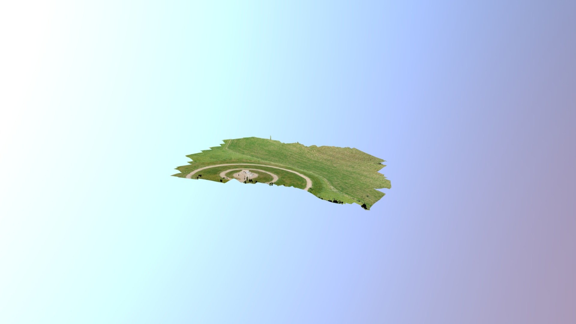
I'd like to use it for 3D photogrammetry.
Apparently, the best way of doing this is through a double-grid mission (not just waypoints or orbits), but when checking available (free) software, it seems to me only Pix4D has this implemented. Is this correct ? It doesn't seem to be the case in DJI GO 4 or Litchi.
I did recently found out about the free version of Dronelink, which looks amazing. Would this be the nec plus ultra app for drone mapping and if so, is it easy to create double-grid missions with it ?
Before I forget : some of my missions involve slopes. Is it easily possible to set different heights for the drone upon such missions ?
Thanks for any help on this...
 
Last edited:
Dronelink does indeed have a double grid for photogrammetry. It works really well.


I recently made this with a Spark and Agisoft metashape. The area is circa 3900m2 and the difference in elevation i about 8m
 
If you are doing this recreationally or for educational use, Dronelink is also free and has double grid also as solely a flight control program.

But as for varying flying heights to maintain a constant AGL for sites with slopes, I have only found that one has to manually set it in all of the free and low cost programs I’ve seen. Have you asked this question on the commercial drone site? There are usually more specialized discussions regarding this topic on this forum:


I wish programs could at least have a good topo map as a background image, it would vastly simplify the process of manually programing heights. I also tried using Virtual Litchi and Google Earth with a manual grid- it lets you program your grid as waypoints on Google Earth which makes setting individual AGL points over terrain a lot easier since it displays this based on its DEM. So you could export a grid generated by something else to it and edit and check it on GE. Either way, its a manual process for sure.

I am very interested in knowing how to do this also if you find out, please keep us posted about it!
 
Last edited:
  • Like
Reactions: Skyflyer129
If you are doing this recreationally or for educational use, Dronelink is also free and has double grid also as solely a flight control program.
I saw a single grid mission on a demo on their site. Do you have a link for a double grid demo ? I tried to replicate the single grid one, but it seems that it automatically decides on the spacing between the parallel navigation lines. Is it possible to manually edit this ?

I also tried using Virtual Litchi and Google Earth with a manual grid- it lets you program your grid as waypoints on Google Earth which makes setting individual AGL points over terrain a lot easier since it displays this based on its DEM
Do you mind transforming this in a small tutorial as how to do this ? Unfortunately, here in Israel, Gmaps are very low res, complicating the task.

LBNL, if I have to do this manually, I guess i have no other choice as to travel to the site i want to capture and to manually raise the drone above let's say the four extremes of the grid i wish to capture to measure it's elevation above ground level. Is that right ?

Oh, forgot this : for the drone, in order to assess the depth of its captures, does it make a difference whether it flies at fixed height in a double grid mission ? A.v. does taking into account AGL points help or actually hinder this ? Would it add something to the final rendering whether one actually combined the two ?
 
Last edited:
Automatic grid spacing is set by choosing camera type, overlap desired and AGL settings in Dronelink. There’s a mission type setting that you also choose for lines and waypoints or other flights including grids.

I haven’t tried it, but I’ll have to look at Google Earth to see if the Israel aerial information is degraded for us in the US as well. If you would like, post an example empty (not sensitive) site there with varying terrain (pinpoints or KML) with terrain and I will try it out here with Dronelink and VLM.
 
hi and thanks. Will check it out. As to resolution, unfortunately it' not geolocated. It's a deal between Israel and Google to degrade quality. Will see if I can find example.
 
Ok, Dronelink will make a grid, however it is not terrain following so you must set it higher than the highest part of your terrain. If the example mission shown below was actually flown, it will crash your drone into the hill on the east side of the grid!

You make the grid by setting a mapping flight plan (see panel below), then choose 'grid' instead of the default 'normal' in the Pattern section (below). You can also see how it sets the grid density by the overlaps, camera type and angle I set the capture at.

DeadSea Dronelink.jpg
 
Last edited:
  • Like
Reactions: mereflyer
Hi and thanks for the well-chosen illustration !
you must set it higher than the highest part of your terrain.
is there an easy way of doing so f.ex. with Gmaps, Bing or anything the like, i.e. pinpointing object on such a map and getting AGL information ?
The only alternative I can think of is actually getting to the site and flying above the highest corner points of the projected map...
 
Hi and thanks for the well-chosen illustration !

is there an easy way of doing so f.ex. with Gmaps, Bing or anything the like, i.e. pinpointing object on such a map and getting AGL information ?
The only alternative I can think of is actually getting to the site and flying above the highest corner points of the projected map...

I will try to find out a better way to do it - DroneDeploy may have more functionality for doing this, but it looks like there is only a 14-day free trial available so I have not tried it yet. Dronelink does not appear to be able to export the grid it created as a KML either, else one could simply export to Litchi Virtual Mission and manually set the heights over Goggle Earth.
I know you said your version of GE was filtered, does that include the elevation data too? If not, it would be useful to get the elevations using it.
 
Last edited:
Thanks !
If the example mission shown below was actually flown, it will crash your drone into the hill on the east side of the grid!
Does this mean Dronelink by default overrides the anti-collision protections of my mavic ? If so, is there a way to (force) enable them ?
manually set the heights over Goggle Earth.
Ok, found the link for LVM and exported path to GE. It' obvious to me it's not terrain-following. Also just found out how to manually edit the LVM waypoints in GE : get info, then fourth tab (altitude). But there, what's the difference between the first option (ground level) and the third one (relative to the ground)?
 
I will try to find out a better way to do it - DroneDeploy may have more functionality for doing this, but it looks like there is only a 14-day free trial available so I have not tried it yet. Dronelink does not appear to be able to export the grid it created as a KML either, else one could simply export to Litchi Virtual Mission and manually set the heights over Goggle Earth.
I know you said your version of GE was filtered, does that include the elevation data too? If not, it would be useful to get the elevations using it.
I think you can export a kml to google earth. That’s kinda one of the features of drone link. I exported my DroneLink mission to google earth and flew the mission virtually in Google earth just like Litchi virtual mission if that’s what you are talking about
 
Hi again. Plotted mission in dronelink. What's the meaning of the (negative) descent and ascent rates and should i leave the defaults?
Capture d’écran 2019-10-14 à 11.15.56.jpg
 
I'm having difficulty altering the density of the grid. I made a new sample mission with 4 boundary points (cf. screenshot) : that gives a reasonable flight time of about 8 mins. That's pattern based and not grid-based. But on my other mission i had to multiply the boundary points because of the terrain and that automatically yielded a much denser grid giving me a 5 hour flight time (in grid mode) ! I can only reduce overlap to 50 % and doesn't help much.
So : is grid density automatically determined by number of boundary points and if so, is there a way to reduce it?
Capture d’écran 2019-10-14 à 11.38.46.jpg
Ok, as I saw that pix4Dcapture was also yielding a very dense grid, found out that the only parameter influencing it is the height. Idem ditto at Dronelink.
So that's basically the only way to reduce grid density : fly higher (with less resolution of course as the consequence)?
 
Last edited:
I think you can export a kml to google earth. That’s kinda one of the features of drone link. I exported my DroneLink mission to google earth and flew the mission virtually in Google earth just like Litchi virtual mission if that’s what you are talking about

Can you describe how to export it? I cant find that function. Thanks!
 
Sorry for adding up one post after another, but first Dronelink flight was epic failure ?...
First, the mission launched, but then aborted itself because drone was too slow (but I had given it 30 kph)...
Then launched again, but got 2 warnings about camera settings. Had to set camera mode, which I added, but still the mission failed.
Aren't the camera settings included in the map profile ?
 
I'm having difficulty altering the density of the grid. I made a new sample mission with 4 boundary points (cf. screenshot) : that gives a reasonable flight time of about 8 mins. That's pattern based and not grid-based. But on my other mission i had to multiply the boundary points because of the terrain and that automatically yielded a much denser grid giving me a 5 hour flight time (in grid mode) ! I can only reduce overlap to 50 % and doesn't help much.
So : is grid density automatically determined by number of boundary points and if so, is there a way to reduce it?
View attachment 83550
Ok, as I saw that pix4Dcapture was also yielding a very dense grid, found out that the only parameter influencing it is the height. Idem ditto at Dronelink.
So that's basically the only way to reduce grid density : fly higher (with less resolution of course as the consequence)?

There are camera settings on Dronelink that set the grid density. Along with height, setting the focal length of the lens and the percent of overlap will also determine the grid density. All three of these variables act together to set the great density.

If your survey area is too large at the grid density you want, it sounds like Starting out with a smaller size sample would be better.
 
Last edited:
Ok thanks. I must admit I get lost with these camera warnings :
Camera Mode attempted before camera stop capture.
Recommendation: Add a camera stop capture command before this command.
Camera Photo Type attempted before camera stop capture.
Recommendation: Add a camera stop capture command before this command.
Camera start capture attempted before camera stop capture.
Recommendation: Add a camera stop capture command before this command in case the camera is already capturing before the Mission starts.
What I would like is that it just starts capturing RAW images every 2 or 3 seconds... How must I 'code' this ?

This is my current try. For the moment no errors. Is this enough ?
Capture d’écran 2019-10-14 à 17.08.23.jpg
 
Last edited:
Any thoughts on the above ? Must one manually set all camera settings even before plotting the mission and if so, will Dronelink automatically capture afterwards?
 
Have you tried MapsMadeEasy? It does double grid and terrain following. Using the app is free; They charge (modestly) for the processing.
 
Hi, i did stumble upon it the other day and its complement MapPilot. I've been delving into the DL tuts lately and it seems less scary than in the beginning. It has great potential. If they could just integrate some decent terrain following and a more user-friendly UI, I believe this is the nec plus ultra for any drone mapping.
 
Lycus Tech Mavic Air 3 Case

DJI Drone Deals

New Threads

Forum statistics

Threads
130,985
Messages
1,558,561
Members
159,972
Latest member
rarmstrong2580