


Hi all, they send me from FB and they told me to ask for a user called @sar104 that could help me narrow my search.
Hi all, lost my drone (DJI Mavic Pro) in a fly-away under strong (30 m/s) winds in high mountain (2500 m, -12 °C). Eventually in the next days will be fully covered by snow.
Disconnected at 42%, while "performing" an RTH, but going away under the wind, and suddenly disconnected. I was North, at 1 Km, and the wind was from E to W, at 30m/s the log showed me the last available position, and I reached in about two hours, with crampons, but without an axle could not go on with the search and the temperature was lowering very quickly.
I have logs until disconnection
Thanks
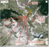
Hi all, lost my drone (DJI Mavic Pro) in a fly-away under strong (30 m/s) winds in high mountain (2500 m, -12 °C). Eventually in the next days will be fully covered by snow.
Disconnected at 42%, while "performing" an RTH, but going away under the wind, and suddenly disconnected. I was North, at 1 Km, and the wind was from E to W, at 30m/s the log showed me the last available position, and I reached in about two hours, with crampons, but without an axle could not go on with the search
and the temperature was lowering very quickly.I have logs until disconnection
Thanks
Attachments
Last edited:


