DJI Mavic, Air and Mini Drones
Friendly, Helpful & Knowledgeable Community
Join Us Now

Mapping recommendations: Web ODM vs Maps made easy

bburnett15

Well-Known Member
Joined
Sep 11, 2020
Messages
197
Reactions
57
Age
65
Location
massachusetts
Im new to mapping and tired of chasing things down on the internet so i’d like to hear from some of you who have experience with either of these. I am at work now and will probably pull the trigger on WebODM tonight after i get home Unless im hearing disturbing feedback.
first let me say that Drone Deploy is cost prohibitive for my purposes.

i have a (new) M3E and will be using that mapping program.
I have tried Skyebrowse and while it is great as tool for first responders, i need something more “standard’ (that is also affordable) while i learn and build a portfolio. Modelling ability is not crucial at this time.

i have been using Maps made Easy and it has worked great but looks like it is going to be about $30 per map based on the areas and level of detail i will be looking at. i am happy with the level of detail i get on maps made easy, (270 images, 13 acres) but i havent figured out how best to employ their point system.

WebODM also looks good and i understand it runs off your desktop But can also use a network server for larger files. I recently upgraded to a MacStudio M1, 1TB and 64GB- I know it should work, but how does this setup sound on the scale of what would be good for WebODM?

i think i may wind up using both- WebODM up to a certain size and then the Pay-As-you-go plan at maps made easy.

thoughts on these two?
 
Last edited:
  • Like
Reactions: Spartan Drones
WebODM is pretty good, *but* it's not particularly user friendly.

I don't mean that it's difficult to use, because it's not. You just set your options, pick your pictures, and let it run. The problem is that you don't get to see any of the intermediate steps. If your pictures didn't align, you're not going to see until everything is finished. If there's a couple thousand pictures, you might have to wait a couple days to find out that something didn't turn out right.

As far as running WebODM on a Mac (or even on a PC if you're doing the free-to-install method), it's not really ideal. You're running essentially inside of a VM and you have to assign a certain amount of resources to the VM. Now, that can be okay: if you're okay with having one arm tied behind your back, you can just put 1/2 of your computer resources toward WebODM and then have the other half left to use for whatever else you might want to do. That's fine- that's what I do when I want to run it on my MBP. I don't *think* you can change that resource allocation mid-run, though. IIRC, the Docker VM requires a restart if you want to change the amount of RAM or number of processors it can use.

Oh- also, last time I checked, I don't think that WebODM will make use of GPU processing on a Mac, though I might be wrong on that. I *think* it only uses CUDA, rather than OpenCL. Check the documentation, though.

If you have the paid installer for PC, though, you no longer run it through the virtual machine, and it will just run based on whatever system resources you have available, not whatever you decide to let it have. PC+nVidia GPU is really the ideal setup, in my opinion.

As far as the results that it gives... the point clouds aren't as dense as I'd like, but they are pretty good quality. Textured model outputs are okay. The really spectacular part, though, is the orthoTIFF output, and since you're doing mapping it sounds like that's what you need. The orthotiff output tends to be very, very good. Even without using GCPs, so long as you have enough pictures for the software to average out the GPS errors, you can get extremely accurate output here- overlaid in whatever GIS program is at hand, I'll frequently find that the map is out of line with reality by, say, half the width of the stripe on the road.

Ultimately, though, I wind up using Metashape more often: the ability to break it down into steps, and make adjustments after the alignment stage if the results aren't what I want, that makes a huge difference in my overall workflow, and I think the improved quality + time saved is worth the cost of the program.
 
I have wasted 3 hours of my life on Web ODM so far and I'm far from done! there's a lot more time that needs wasting before I will be able to find a use for this ! the files I've sent it that I've already processed in maps made easy have both died on the vine.
 
  • Haha
Reactions: Rusty_SWO
I have wasted 3 hours of my life on Web ODM so far and I'm far from done! there's a lot more time that needs wasting before I will be able to find a use for this ! the files I've sent it that I've already processed in maps made easy have both died on the vine.
I would suggest feeding it your pictures at default settings first. If you've got ~300 pictures at default settings, with that much computer it should finish up in a couple hours or so.

While it's running, read through the documentation about all the settings and what they mean / do. There's a lot in there that can go wrong along the way. You want to have an idea what they all mean before you start to mess with them.

Oh- one other thing: not sure what MME is going to do as far as the gimbal angle (I could never get it to work at all for me. It just raised my drone to altitude and then... went c ompletely unresponsive), but I seem to recall that WebODM prefers that you not have your pictures taken at zenith. I think I got my best results with about -75 or so.
 
  • Like
Reactions: bburnett15
Ill give it another go and i do need to understand - this is a completely different language than anything i know. It sounds like DOS, but i dont Remember how to use that and it also sounds like the FORTRAN computer programs i was learning in the ‘70s (i dont remember that either)
i need a rosetta stone……

Whoa now. What? DOS?

Are you trying to use this in command-line format?!?!?!?!?!?
 
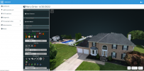
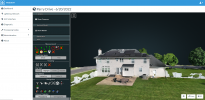
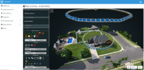
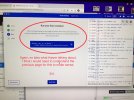
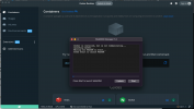
I’ve used WebODM just to get the hang of how to do 3D modeling and mapping. I find that once I get above 120 images it’s a crap shoot as to if it will complete or fail after 40 min processing. I’m too cheap to pay a per use charge if only doing for hobby. If I was doing for a job I’d invest in something more robust and easier to use. This was just a quick job I ran in Web ODM taking pics circling our house (maybe 100 images - give or take a few). Seeing as WebODM is free - it’s not bad to play around with and learn.A546AB42-7E07-4D4C-895F-B5360C2B526F.png8FEE6244-F37F-42E5-81F7-562053EE682E.png3C8AA31B-3C67-4C81-A55A-495443D348D6.png
 
The stuff ive seen from WebODM all looks like good quality stuff.
that said, my poblem seems to be that i am using a Mac for something made to wok on a PC.
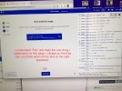
the attahed photos are marked with notes highlighting my confusion
 

Attachments

  • 1ED72476-0030-443F-AAF2-39DF52445CD6.jpeg
    1ED72476-0030-443F-AAF2-39DF52445CD6.jpeg
    732.8 KB · Views: 20
  • EFBA3E1E-CC2E-4484-BC76-C70AE0779844.jpeg
    EFBA3E1E-CC2E-4484-BC76-C70AE0779844.jpeg
    835.6 KB · Views: 17
  • BF352284-09AF-47D1-BB32-4D741C2F50A7.jpeg
    BF352284-09AF-47D1-BB32-4D741C2F50A7.jpeg
    861.1 KB · Views: 17
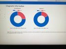
Here is the diagnostic when i submitted 257 images and after 20 minutes got a “not enough room” message
 

Attachments

  • 57C89BBA-FE39-4E3D-B84D-B02735B87A93.jpeg
    57C89BBA-FE39-4E3D-B84D-B02735B87A93.jpeg
    1.1 MB · Views: 11
You're trying to do the manual install, it looks like. But you paid for the pre-made installer?
Yes i paid for the “simple” installer. Are you on a Mac or PC? Ihave never had good luck with the workaround programs that supposedly enable macs to use software written for PCs. It never works as well.
 
Here is the diagnostic when i submitted 257 images and after 20 minutes got a “not enough room” message

You're going to want more resources than that, I suspect... I usually give it 6 of 8 cores and 24 of 32 GB RAM, when I'm running the docker version on Mac.
Yes i paid for the “simple” installer. Are you on a Mac or PC? Ihave never had good luck with the workaround programs that supposedly enable macs to use software written for PCs. It never works as well.

I user both Mac and PC, depending on what I'm doing or what day it is or whatever I feel like using that day.

Did you actually get the simple installer? What you're showing there doesn't look like what I see when I run on my Mac.

This is what I see:

1670514291566.png

From there, I just click "start" and it opens up a new browser tab, then "stop" or "shut down" or something like that when I'm done, and then I can close WebODM manager and Docker. I don't ever have to mess with Docker in and of itself unless I want to change the amount of resources available to it.
 
I’ve used WebODM just to get the hang of how to do 3D modeling and mapping. I find that once I get above 120 images it’s a crap shoot as to if it will complete or fail after 40 min processing. I’m too cheap to pay a per use charge if only doing for hobby. If I was doing for a job I’d invest in something more robust and easier to use. This was just a quick job I ran in Web ODM taking pics circling our house (maybe 100 images - give or take a few). Seeing as WebODM is free - it’s not bad to play around with and learn.View attachment 158026View attachment 158027View attachment 158028
What are the hovering rings in the last picture?
 
Im new to mapping and tired of chasing things down on the internet so i’d like to hear from some of you who have experience with either of these. I am at work now and will probably pull the trigger on WebODM tonight after i get home Unless im hearing disturbing feedback.
first let me say that Drone Deploy is cost prohibitive for my purposes.

i have a (new) M3E and will be using that mapping program.
I have tried Skyebrowse and while it is great as tool for first responders, i need something more “standard’ (that is also affordable) while i learn and build a portfolio. Modelling ability is not crucial at this time.

i have been using Maps made Easy and it has worked great but looks like it is going to be about $30 per map based on the areas and level of detail i will be looking at. i am happy with the level of detail i get on maps made easy, (270 images, 13 acres) but i havent figured out how best to employ their point system.

WebODM also looks good and i understand it runs off your desktop But can also use a network server for larger files. I recently upgraded to a MacStudio M1, 1TB and 64GB- I know it should work, but how does this setup sound on the scale of what would be good for WebODM?

i think i may wind up using both- WebODM up to a certain size and then the Pay-As-you-go plan at maps made easy.

thoughts on these two?
I too am pretty new to this, the online name brand software is way to expensive for someone trying to learn how to put out a good product. I have used WebODM on a PC and had zero issues. I did pay the extra to have the program installed and run with a graphic user interface. once you get the bugs worked out on the installation, I am sure you will have some success.
 
  • Like
Reactions: bburnett15
What are the hovering rings in the last picture?
It shows all the pics that are taken with the camera - part of the app will show each pic you took as it relates to the overall map or 3D model. I think I had it taking pics ever 2 sec and did a slow circumference flight at 2 different altitudes.
 
Thanks for your experience. I have spent hours if not days exploring mapping platform options. The bottom line for me is that I as @DAVID Young said, must be clear on what results I need for the project (remembering that you pay for what you get.).

In short I think that maps made easy is simple, cost effective and efficient.

Agisoft Metashape is for me the Rolls Royce for this software in all respects (Though the company is headquartered in St Petersburg, Russia, if you care).

We data capturers would do well to have a data broker whereby we could type in our requirements and get advice about appropriate options.

For example geonadir processes orthomosaics for free if you are into contributing and sharing with their environmentally focused database.
 
Lycus Tech Mavic Air 3 Case

DJI Drone Deals

New Threads

Forum statistics

Threads
130,974
Messages
1,558,494
Members
159,964
Latest member
swigmofa