Hello,
The newest update brings a altitude optimalisation. But the limit is still 500m. What does it mean? Im in CE region.
The newest update brings a altitude optimalisation. But the limit is still 500m. What does it mean? Im in CE region.

What does the newer Altitude optimalisation mean? It came with latest update.What does what mean?
If you are refering to height, you might find
useful.Max altitude 500m --> 1,000m?
UPDATE: resolved, see details below. I've seen a few people commenting that with the 12/9 update M3 can fly up to 1,000m up from the HP rather than only 500m as before. I have updated my M3C, yet the max altitude still shows as 500m (1,640ft). I wonder if the limit is country/area-specific...forum.dji.com
The 500m altitude zone is everywhere, and now hides the real altitude zones, and obliterates the map with a gray overlay, making it impossible to use! Only by removing all altitude zones can you remove the obvious new 500m zone overlay, which also removed the real altitude zones! No way to use the new 1000m altitude limit, even after accepting responsibility for it, as the 500m limit is imposed everywhere!There is more to the news than an increase to 1000m which some people seem to "get" and others do not in spite of being up to date. One of the things I saw in the links above was a comment about new altitude zones of 500m. I looked locally and once the Geo Zone Map web page was set for Mavic 3 I did indeed see new, very large, altitude zones of 500m. Of course 500m (1640feet) has always been the limit DJI has set for altitude above take-off so it seems the only thing that has changed in this regard is we now have large areas where ...what? It's just a notice? Requires a check box to acknowledge? Does that mean outside the 500m zones it is now 1000??
P much correct. As I said in that thread there are new 500m altitude zones everywhere. You may notice that these are all 50km radius circular zones around major airports. Thus, if you are stationed at least 50km away from a major airport, you will be able to fly to 1000m without any special unlocking procedure.There is more to the news than an increase to 1000m which some people seem to "get" and others do not in spite of being up to date. One of the things I saw in the links above was a comment about new altitude zones of 500m. I looked locally and once the Geo Zone Map web page was set for Mavic 3 I did indeed see new, very large, altitude zones of 500m. Of course 500m (1640feet) has always been the limit DJI has set for altitude above take-off so it seems the only thing that has changed in this regard is we now have large areas where ...what? It's just a notice? Requires a check box to acknowledge? Does that mean outside the 500m zones it is now 1000??
There are always lower Altitude Zones within those 500m 50km radius zones, coming off the bowtie flight lines of the airport, and the new gray 500m gray overlay now hides the entire map behind it, for a mountain climbing feature that would only ever be relevant more than 50km away! Dumb implementation!P much correct. As I said in that thread there are new 500m altitude zones everywhere. You may notice that these are all 50km radius circular zones around major airports. Thus, if you are stationed at least 50km away from a major airport, you will be able to fly to 1000m without any special unlocking procedure.
Within the altitude zones, you can specially request to get permission to fly above 500m to 1000m from DJI (just like with the other zones). I am quite confident in saying that getting a 500m altitude zone unlock from DJI would be quite difficult.
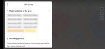
Yeah the implementation's not the best. Although for me at least it is still functional. You can see all the altitude zones in the drop down on the mobile app. However, in areas with a lot of airports you end up with something like this lol.There is a new "Special Altitude Zones" map layer with its own checkbox. However, I haven't been able to determine what a "Special Altitude Zone" is. Anyone else figured it out yet? Toggling it off and on makes no apparent change to the map, no matter how far I zoom in or out, and by out I mean including showing outside the perimeters of the the 50km radiuses around every airport.
I have also discovered that the obliterating gray 500m layer disappears temporarily while touching the screen, without turning Altitude layers off. Also, it now appears that red NFZ's and blue Authorization Zones at least appear on top of the otherwise obliterating gray layer, while still hiding all map detail behind the gray layer.
Lastly, the gray 500m Altitude layer is not removed by keeping the max height at the default of 500m, and the gray layer is so obstructive that the satellite view looks like the normal view, and no apparent change takes place when switching between them, until you physically touch the screen to clear the gray layer, while still holding your finger on the screen, and, you can then drag the visible map until you let go, and then the obstructive gray layer returns.
Hiding the Altitude Zones layer now still hides the previous real altitude zones that are bow ties off the airport NFZ flight lines, so they no longer have any shape outline either! Touching inside those hidden areas of the screen will sometimes bring up an "Altitude Limited to XXX Feet" but at other times wrongly shows they are still 500m!
Dumb and misleading implementation!
Yes, that is what I was hoping the Special Altitude Zones filter was created for! However, toggling that map layer doesn't yet do anything that I can see. Maybe they forgot to enable it!Yeah the implementation's not the best. Although for me at least it is still functional. You can see all the altitude zones in the drop down on the mobile app. However, in areas with a lot of airports you end up with something like this lol.
Completely functional but I imagine that they will move the 500m altitude zones to their own filter in the future
Completely depends upon whether your mountain is within a 50km radius of any airport! If yes, then certainly not. Otherwise, you are now golden!Has anyone been successful in being able to fly above the 1640ft limit? Traveling to the mountains in a few days and would love to be able to summit the mountain
WOW ok thanks! Sadly this one is probably 10-20 miles from an airport.Completely depends upon whether your mountain is within a 50km radius of any airport! If yes, then certainly not. Otherwise, you are now golden!
There are small unregulated airports that do not cause there to be a limitation. In fact Valdez with its’ airport does not throw up a 1640ft limitation around it. It’s population is only around 3500…which still puts it in our 30 largest towns.WOW ok thanks! Sadly this one is probably 10-20 miles from an airport.