DJI Mavic, Air and Mini Drones
Friendly, Helpful & Knowledgeable Community
Join Us Now

Mavic Mini flyaway in a forest

vladlst

New Member
Joined
Apr 1, 2020
Messages
4
Reactions
1
Age
35
Location
Belarus
Hi,
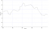
Everything was ok but at some point the wind began to blow my drone in the opposite direction from me, not a single direction controller worked well, the automatic return home did not work either, the battery dropped to 24% due to the wind and when the drone flew far away from me, I lost the signal. This is a forest, so I was already looking for it quite strongly at the last GPS-point on the map, but I would like to ask the experts: since I lost the signal at 24%, could the wind blow it away somewhere further this point on the map? Where should I look for it? And the wind wasn't so strong that the drone could not withstand at all. Strange.
My log is here: https://app.airdata.com/share/SjgRBi

Thanks!
 

Attachments

  • DJIFlightRecord_2020-03-29_[17-42-34].txt
    1,009.8 KB · Views: 18
Yeah ... a clear Blow Away case, downwind flying with to strong wind combined with to high altitude & use of the RTH button as a "panic" button. It should be possible to pinpoint the touch down location with pretty high accuracy ... the tree height (which it will hit first during landing) needs to be taken into consideration.

@sar104 is the one with interpolation possibilities ... to predict were it can be (but jeez ... it's a lot of trees, kind of a needle in a haystack)

The winds in the flight until disconnect:
1585742327073.png
1585742340586.png

A lot of wind warnings in the log's event stream that was ignored ...

1585742401233.png

And here what happened in the last RTH phase before complete disconnect:

At 114m height the Mini drifted with in average 2,3m/s downwind with failsafe RTH initiated, no stick inputs at all ... at the time 24% battery was left & a set autoland at 8%. It had 309sec useful time left.

1585742454083.png
 
Last edited:
  • Like
Reactions: vladlst
The drone didn't "fly away" at all.
This flight was doomed from the start.
You launched with the battery at 65%.
You put the drone up where the wind was stronger than it could fly against and let it be blown away.
the automatic return home did not work either
RTH worked exactly as it is programmed to.
But the wind up at 114 metres was stronger than the Mini can fly against, and the Mini was blowing backwards at 1.5-3 metres/sec.
when the drone flew far away from me, I lost the signal.
When the drone was blown far away, it lost signal
I was already looking for it quite strongly at the last GPS-point on the map
It's not going to be near the last recorded position, because when signal was lost, the Mini was 114 metres up and being blown further south at 1.5-3 m/s.
It will have blown further south until the battery reached critical low voltage and commenced autolanding.
And the wind wasn't so strong that the drone could not withstand at all. Strange.
The data shows that the wind was stronger than you thought.
 
OK ... I will give it a shoot until SAR104 arrives & corrects me :D

Used for the calculation ...

-An average battery % consumption in the end of approx 1% each 10,9sec
-16% battery to go until battery auto land initiates at 8%
-Equals 174,4sec left until battery auto land initiates
-111m RTH height (already at 114m so will not descend)
-Average drift speed 2m/s
-Equals 349m to go until landing starts (start of green zone)
-HP at 204m ASL, possible touch down aread at 240m ASL
-Equals land area 36m higher then HP
-Equals height above HP 114m - 36m -20m (tree top height) = 58m descent until tree tops
-Descent speed for the Mini is 1,8m/s
-Equals 32sec to reach tree tops drifting with 2m/s
-Equals further 64m away until tree tops
-Equals touch down in tree tops at 349m+64m = 413m from last in log reported position.
-The width of area consists of the 2 last drift angles in the log.

So ... tree top hit between those two GPS positions in the yellow area.

So now lets see how wrong I am when @sar104 have looked over this ... ;)

1585765846400.png
 
Last edited:
While we’re waving on @sar104 .... Besides all the points of information made I feel two bear emphasis.
1. Don’t launch if winds may exceed the drone’ capabilities.
2. Always try to make the return leg downwind as well as never launching with a battery < 100% charge.
Some events are not avoidable.... but these errors are drone killers.
 
OK ... I will give it a shoot until SAR104 arrives & corrects me :D

Good work slup, you'll be up there with sar104 in no time mate !

Gives SAR some input and also the OP an area to start checking out on the map for access points etc for a search.
Not far from the road / dirt track or road reserve there, and the trees / ground look reasonably open.
 
  • Like
Reactions: vladlst
OK ... I will give it a shoot until SAR104 arrives & corrects me :D

Used for the calculation ...

-An average battery % consumption in the end of approx 1% each 10,9sec
-16% battery to go until battery auto land initiates at 8%
-Equals 174,4sec left until battery auto land initiates
-111m RTH height (already at 114m so will not descend)
-Average drift speed 2m/s
-Equals 349m to go until landing starts (start of green zone)
-HP at 204m ASL, possible touch down aread at 240m ASL
-Equals land area 36m higher then HP
-Equals height above HP 114m - 36m -20m (tree top height) = 58m descent until tree tops
-Descent speed for the Mini is 1,8m/s
-Equals 32sec to reach tree tops drifting with 2m/s
-Equals further 64m away until tree tops
-Equals touch down in tree tops at 349m+64m = 413m from last in log reported position.
-The width of area consists of the 2 last drift angles in the log.

So ... tree top hit between those two GPS positions in the yellow area.

So now lets see how wrong I am when @sar104 have looked over this ... ;)

View attachment 97708

Agreed on the time to autoland start - I get 173.9 seconds:

Battery.png

The drift speed is rather variable though:

speed.png

Your assumption of 2 m/s is not unreasonable, but to bound it I think one needs to consider the range of 1.5 – 2 m/s. Plotting those gives a range of distances to landing of 328 m – 438 m with a landing area around 35 m higher than the takeoff point.

In terms of direction you need to look at course and motor heading.

Course.png

When it is trying to hover those are 180° out, as expected, but in RTH it doesn't directly fight the wind. I think your predicted track is too far west. The final recorded course was 135°. I'd put a 10° uncertainty around that, giving the following prediction:

grab39.jpg

1585802419860.png

Unfortunately that's around 500 m² of quite thickly forested terrain.
 

Attachments

  • speed.png
    speed.png
    28.5 KB · Views: 8
@sar104 how do you get the motor thrust direction, can you possibly describe out from my tools (CsvView) how to get to that, can't be tiltdirection or?

Then also ... did you count in that the AC probably hit tree tops first & didn't go so much further then that?
 
@sar104 how do you get the motor thrust direction, can you possibly describe out from my tools (CsvView) how to get to that, can't be tiltdirection or?

Then also ... did you count in that the AC probably hit tree tops first & didn't go so much further then that?

Motor thrust direction is computed from the orientation quaternions as follows:

θ = atan2(-(qx*qz + qy*qw), (qy*qz - qx*qw))​

From the sound of it, that will be tiltdirection in CsvView.

The height of the trees is an unknown, but the effect of earlier than predicted contact with the ground is taken into account by the 20 m buffer on the start of the predicted minimum flight distance.
 
  • Like
Reactions: vladlst and slup
Another tip to attempt recovery of control when wind gets the best of you:

Do not use RTH for any reason. Doing so will limit your speed and likely put you higher altitude with higher winds.
Instead put yourself in sport mode and use the map to orient the AC to point towards you.
Descend as low as you can without danger of obstacles or signal loss.
 
  • Like
Reactions: vladlst
Or if your map is screwed up, red arrow orientation is suspect, or you can't see the green line for some reason (glare or whatever), you can always initiate RTH, monitor the distance to confirm the drone is getting closer to you, then cancel RTH and proceed.

Another tip to attempt recovery of control when wind gets the best of you:

Do not use RTH for any reason. Doing so will limit your speed and likely put you higher altitude with higher winds.
Instead put yourself in sport mode and use the map to orient the AC to point towards you.
Descend as low as you can without danger of obstacles or signal loss.
 
I think the drone was showing ESC errors from 25 sec and looked to be having issues responding to commands well before the strong wind warning popped up at 90 sec. That being the case could you seek to have it replaced under warranty due to equipment failure leading to the wind blown flyaway? Those technical types @slup @sar104 any evidence early on to support this theory and help @vladlst get a replacement from DJI?
 
I think the drone was showing ESC errors from 25 sec and looked to be having issues responding to commands well before the strong wind warning popped up at 90 sec. That being the case could you seek to have it replaced under warranty due to equipment failure leading to the wind blown flyaway? Those technical types @slup @sar104 any evidence early on to support this theory and help @vladlst get a replacement from DJI?

If you mean if it's signs of the "uncommanded descent" in this flight ... unfortunately no, the Mini responded well to throttle inputs & didn't had any height instability.
Comparing the Throttle input (Blue) to the Z-speed (Green, positive=descent) all behaves well during the whole flight.

So no ... that can't be used as an argument to get a replacement.

1586077855072.png
 
  • Like
Reactions: vladlst and sar104
I've received the answer from DJI support:


"For your case CAS-4140463-T1M0Z4, we have finished the analysis, and the result is as follows:

1. The aircraft worked under GPS mode; It could not respond to the pilot’s commands well due to the strong wind from the northwest;
2. Flight Time T=01:25, Relative Height H=27.1 m, Distance to Home Point D=28.4 m, the warning of "Strong wind warning. Aircraft unable to fly stably. Lower altitude immediately and manually return to home" pop up;
3. T=05:51, H=81.9 m, D=211.8 m, there was no pilot’s input, the aircraft tilted 19.6 degrees forward to resist the wind, but it was still blown away at the speed of 1.4 m/s, which indicated that there was strong wind affecting the aircraft;
4. T=05:53, H=82.1 m, D=215.0 m, RTH was triggered by the pilot but the aircraft could not return home normally due to the strong wind;
5. T=08:33, H=114.1 m, D=599.0 m, the flight record ended when the aircraft was blown away by the strong wind.

According to the current analysis, the incident was caused by an improper flight environment with strong wind. But if you have any further information that can be added, regarding the flight environment, the wind velocity or the detail of the incident (e.g. related video or data), or any questions regarding this analysis, please feel free to let me know, we'd like to review your case and provide you a proper solution."
 
With a little luck, they may offer you a small % discount on a new aircraft body, and maybe another battery.
Let us know if they do this, it would be a positive sign of good customer support.
They really have no obligation as it seems they assess it as pilot error.
 
I've received the answer from DJI support:


"For your case CAS-4140463-T1M0Z4, we have finished the analysis, and the result is as follows:

1. The aircraft worked under GPS mode; It could not respond to the pilot’s commands well due to the strong wind from the northwest;
2. Flight Time T=01:25, Relative Height H=27.1 m, Distance to Home Point D=28.4 m, the warning of "Strong wind warning. Aircraft unable to fly stably. Lower altitude immediately and manually return to home" pop up;
3. T=05:51, H=81.9 m, D=211.8 m, there was no pilot’s input, the aircraft tilted 19.6 degrees forward to resist the wind, but it was still blown away at the speed of 1.4 m/s, which indicated that there was strong wind affecting the aircraft;
4. T=05:53, H=82.1 m, D=215.0 m, RTH was triggered by the pilot but the aircraft could not return home normally due to the strong wind;
5. T=08:33, H=114.1 m, D=599.0 m, the flight record ended when the aircraft was blown away by the strong wind.

According to the current analysis, the incident was caused by an improper flight environment with strong wind. But if you have any further information that can be added, regarding the flight environment, the wind velocity or the detail of the incident (e.g. related video or data), or any questions regarding this analysis, please feel free to let me know, we'd like to review your case and provide you a proper solution."

Accurate enough assessment. I'd be curious to know what kind of software they use to examine the logs. Their explanations always seem rather superficial.
 
Accurate enough assessment. I'd be curious to know what kind of software they use to examine the logs. Their explanations always seem rather superficial.
Perhaps not so surprising ... they probably want to keep it short & basic not open to many entries into argumentation.
 
Lycus Tech Mavic Air 3 Case

DJI Drone Deals

New Threads

Forum statistics

Threads
130,978
Messages
1,558,530
Members
159,968
Latest member
skyscansurveys