DJI Mavic, Air and Mini Drones
Friendly, Helpful & Knowledgeable Community
Join Us Now

Mavic Mini Log Help

Dave_irl

Member
Joined
Dec 7, 2022
Messages
6
Reactions
2
Age
48
Location
Ireland
Hi Guys,
I flew my mini 2 and had some issues ending up with the drone landing in the river :-(

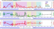
I made a video and then hit RTH and then things went pear shaped - is it possible to see in the logs when a RTH was issued? is it possible to see wind speed from logs?

Logs here : DJI Flight Log Viewer - PhantomHelp.com
Drone never made it back re RTH or when battery was depleting - should it have come back once the battery was almost drained? At one point it wasn't too far away from me but then went further out.
Any insight to the logs? Complete newbie here so thanks for any help.

Cheers,
Dave.
 
You have strong wind warnings and the prompt to return home manually.
 
You have strong wind warnings and the prompt to return home manually.
Yeah I see that is there a way to see what time the RTH was initiated? was it before or after the Wind warning ?

Is there a way to see what the wind speed was?
 
This is a classic "Blow Away" due to being ignorant about how wind affect a drone & how to act if stuck down wind with little to no HP progress... nothing more.

You placed your drone down wind & remained up on height (approx. between 140-180m above HP) the whole time until the critical low voltage landing started. Your log is littered with wind warnings starting already at 01m 50s into the flight... but you ascended further & continued to fly anyway. If you had aborted the flight early & descended, you might have reached back to the HP. Once stuck down wind your only alternatives left was descending as low as possible without losing the connection... or if that didn't gave you progress, scout out a emergency landing location for a later pick up.

In one instance at around 08 minutes into the flight your drone faced a direct head wind, you applied full elevator forward in Sport mode... but the drone drifted backwards with approx. 1m/s anyway, with a max air speed of 16m/s in Sport according to the specs, that meant that you there had a 17m/s head wind.

This was the calculated wind speeds & directions (calculated out from the crafts attitude & achieved ground speed).

1670414684516.png
1670414721896.png
 
Last edited:
This is a classic "Blow Away" due to ignorance about how wind affect a drone & how to act if stuck down wind with little to no HP progress... nothing more.

You placed your drone down wind & remained up on height (approx. between 140-180m above HP) the whole time until the critical low voltage landing started. Your log is littered with wind warnings starting already at 01m 50s into the flight... but you ascended further & continued to fly anyway. If you had aborted the flight early & descended, you might have reached back to the HP. Once stuck down wind your only alternatives left was descending as low as possible without losing the connection... or if that didn't gave you progress, scout out a emergency landing location for a later pick up.

This was the calculated wind speeds & directions (calculated out from the crafts attitude & achieved ground speed).

View attachment 157991
View attachment 157993
Thanks for the analysis. Somewhere between points F&G I hit the RTH button unfortunately for me the RTH height was set far too high and thats why the drone ascended I wasn't actually controlling it.

I tried to get it to descend but not sure why it wouldn't come down.
 
Thanks for the analysis. Somewhere between points F&G I hit the RTH button unfortunately for me the RTH height was set far too high and thats why the drone ascended I wasn't actually controlling it.

I tried to get it to descend but not sure why it wouldn't come down.
According to the log you only applied a descend command very sporadically... not really changing the fact that your drone remained high. And you is always the only one controlling the drone... you can abort the RTH, switch to Sport mode & descend.
 
  • Like
Reactions: Dave_irl
is there a way to see what time the RTH was initiated? was it before or after the Wind warning ?
RTH was initiated several times. The wind level was at moderate/strong before the first time RTH was initiated at 2m 56.9s..

1670416423479.png


1670416497695.png
 
  • Like
Reactions: Dave_irl
  • Like
Reactions: Dave_irl
...... unfortunately for me the RTH height was set far too high.....
Sorry about the drone.
I don't use the 1.8 version of the App but I suspect that if you had opened the map in the lower lower left of the phone's screen and then clicked the icon in the upper right corner of the map window you would have access to an 'artificial horizon'/attitude-indicator, much like the one on the right of the Phantomhelp aerial view.
If it's in 1.8 it would have shown you the large tilts the drone was using to 'fight'-the-wind / fly-at-the-speed-commanded.
The attached shows the drone's pitch, roll, ground speed and 'flight mode'.

Just for future reference, I think you will find that the legal height limit in Eire is 400ft/121m above the ground beneath the drone i.e. a weighted string that length must be touching the ground beneath the drone.
You may be into manned aircraft space at the heights reached in this flight.
So, unless flying up hill etc. I generally set the max height to well under 400ft (UK) and I generally reset the RTH limit when ever I fly in a 'new' location to the height of the highest obstacle + 10m or so.
If a drone has to climb to RTH height an excessively high RTH height wastes battery power in the climb and descent and, as you have discovered, risks putting the drone up into fast wind.

The App will not allow the RTH height to be higher than the max height and will reduce the RTH if necessary.
 

Attachments

  • pitch roll speed.png
    pitch roll speed.png
    47.8 KB · Views: 7
  • Like
Reactions: Dave_irl
Sorry about the drone.
I don't use the 1.8 version of the App but I suspect that if you had opened the map in the lower lower left of the phone's screen and then clicked the icon in the upper right corner of the map window you would have access to an 'artificial horizon'/attitude-indicator, much like the one on the right of the Phantomhelp aerial view.
If it's in 1.8 it would have shown you the large tilts the drone was using to 'fight'-the-wind / fly-at-the-speed-commanded.
The attached shows the drone's pitch, roll, ground speed and 'flight mode'.

Just for future reference, I think you will find that the legal height limit in Eire is 400ft/121m above the ground beneath the drone i.e. a weighted string that length must be touching the ground beneath the drone.
You may be into manned aircraft space at the heights reached in this flight.
So, unless flying up hill etc. I generally set the max height to well under 400ft (UK) and I generally reset the RTH limit when ever I fly in a 'new' location to the height of the highest obstacle + 10m or so.
If a drone has to climb to RTH height an excessively high RTH height wastes battery power in the climb and descent and, as you have discovered, risks putting the drone up into fast wind.

The App will not allow the RTH height to be higher than the max height and will reduce the RTH if necessary.
thanks for the info much appreciated. Strange thing is that on all of the other log files for the previous flights the RTH Height was set to 31m. I don't remember changing it to 179m maybe I did it inadvertently.
 
  • Like
Reactions: Yorkshire_Pud
I don't remember changing it to 179m maybe I did it inadvertently.
Ahhhh the curse of those beep beeping slider buttons for limit adjustment, they are too easily accidentally dragged. I have done the same thing myself with the same result, way way up there (I'd lost contact), though I got away with mine. I had been up a hill which is why the max height limit didn't keep it under 400ft.
It took a LLLOOOOONNNNNGGGGGG time to get is down from up there and I was 'nervous' the whole way down until it was comparatively low as it was over the sea. If there had been wind .....bye bye drone.
 
Last edited:
  • Like
Reactions: Dave_irl
Ahhhh the curse of those beep beeping slider buttons for limit adjustment, they are too easily accidentally dragged. I have done the same thing myself with the same result, way way up there (I'd lost contact), though I got away with mine. I had been up a hill which is why the max height limit didn't keep it under 400ft.
It took a LLLOOOOONNNNNGGGGGG time to get is down from up there and I was 'nervous' the whole way down until it was comparatively low as it was over the sea. If there had been wind .....bye bye drone.
I can well imagine - my heart sank with mine :-( - What did you use to generate those graphs?
 
  • Like
Reactions: Yorkshire_Pud
Ahhhh the curse of those beep beeping slider buttons for limit adjustment, they are too easily accidentally dragged...
Well... in this incident that didn't matter, the OP put up the craft well over 500ft by him self manually. He gave full throttle & full negative elevator from start and didn't let of the sticks until he was very near the RTH height... and RTH will not descend to a lower set height, it remains at the present.
 
  • Like
Reactions: Yorkshire_Pud
Lycus Tech Mavic Air 3 Case

DJI Drone Deals

New Threads

Forum statistics

Threads
130,985
Messages
1,558,561
Members
159,972
Latest member
rarmstrong2580