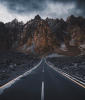
Hey guys! This might not be the right place to post this but no harm in trying I suppose. I'm based out of the Karakoram range of Pakistan (where K2 / Nanga Parbat are - also attaching some photos down below) - I get a lot of people who come out here and at times travel with me and a lot of them show up with a drone, almost always a Mavic/Phantom. Thing is, while some of them are absolutely amazing at aerial photography/filming, some (like myself) have a long way to go before mastering this art. I was wondering if there was a way to get some sort of a workshop going where anyone on here that's interested could sign up and travel out here, spend a few weeks in Spring/Fall and one of y'all could teach? I know I'd love to learn. There's a fine line between being able to fly the drone and being able to understand how to get the most out of your flight in terms of great shots, beautifully captured. Just thinking out loud here. Would love to hear your thoughts and see if this could actually happen post-COVID! Safe trails!! Naveed


 I
I
I