Hi,
I was expecting a "standard" GPS accuracy in terms of absolute accuracy (say ±5 m) , when I remarked once that the EXIF of my images was showing GPS Altitude "Below Sea Level" !!! ... OK, I live on an island next to the sea...
So, i did the following test:
I went in a place where there is an Elevation Benchmark from the National Geodesy Institute... The elevation is given to be +50m above sea level.
All my drone test were done in full open skies: no house, no trees around the takeoff point, at the summit of a small hill...
1st test:
I wait 2-3mn after drone & RC powering to make sure that the GPS sats are fully acquired (13 to 16 were visible) and elevation solution is OK, wait for "RTH point has been updated" message, I started the flight... once 20m above RTH, I took a photo, I was expecting the GPS altitude to be around 20+50= 70m AMSL
Surprise on the EXIF >> GPS Altitude: 0.2 m Above Sea Level instead of +70m AMSL
The Relative altitude (above RTH) was given at 20 meters, meaning that the DGPS from RTH was correctly calculated
Conclusion: The GPS initialisation after 2-3 mn was calculated below sea level, at around -70m Below MSL
2nd test:
I changed place and wait up to 4-5mn after drone & RC powering to make sure that the GPS sats are acquired (same number 15 were visible) . Again wait for "RTH point has been updated" message, I started the flight... once ±75m above RTH I took a photo , I was again expecting the GPS altitude to be 75+50= 125m AMSL
Surprise on the EXIF >>
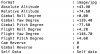
Absolute Altitude : +43.90
Relative Altitude : +74.60
GPS Altitude : 43.9 m Above Sea Level
Conclusion: The GPS initialisation after 4-5 mn was calculated below sea level, now at around -80m Below MSL
I started to think that the so called "GPS altitude" was affected by the geoidal elevation... but in my area (35.87 14.56) the geoidal value is around 37m... nothing to see with 70m to 80m ....
So, I have no clue of what happened to my Mavic 2 GPS to be so poor in Altitude accuracy, it should be in a range of
5 -10 m in my experience!!
Some ideas/opinion or help?
Thanks
I was expecting a "standard" GPS accuracy in terms of absolute accuracy (say ±5 m) , when I remarked once that the EXIF of my images was showing GPS Altitude "Below Sea Level" !!! ... OK, I live on an island next to the sea...
So, i did the following test:
I went in a place where there is an Elevation Benchmark from the National Geodesy Institute... The elevation is given to be +50m above sea level.
All my drone test were done in full open skies: no house, no trees around the takeoff point, at the summit of a small hill...
1st test:
I wait 2-3mn after drone & RC powering to make sure that the GPS sats are fully acquired (13 to 16 were visible) and elevation solution is OK, wait for "RTH point has been updated" message, I started the flight... once 20m above RTH, I took a photo, I was expecting the GPS altitude to be around 20+50= 70m AMSL
Surprise on the EXIF >> GPS Altitude: 0.2 m Above Sea Level instead of +70m AMSL
The Relative altitude (above RTH) was given at 20 meters, meaning that the DGPS from RTH was correctly calculated
Conclusion: The GPS initialisation after 2-3 mn was calculated below sea level, at around -70m Below MSL
2nd test:
I changed place and wait up to 4-5mn after drone & RC powering to make sure that the GPS sats are acquired (same number 15 were visible) . Again wait for "RTH point has been updated" message, I started the flight... once ±75m above RTH I took a photo , I was again expecting the GPS altitude to be 75+50= 125m AMSL
Surprise on the EXIF >>
Absolute Altitude : +43.90
Relative Altitude : +74.60
GPS Altitude : 43.9 m Above Sea Level
Conclusion: The GPS initialisation after 4-5 mn was calculated below sea level, now at around -80m Below MSL
I started to think that the so called "GPS altitude" was affected by the geoidal elevation... but in my area (35.87 14.56) the geoidal value is around 37m... nothing to see with 70m to 80m ....
So, I have no clue of what happened to my Mavic 2 GPS to be so poor in Altitude accuracy, it should be in a range of
5 -10 m in my experience!!
Some ideas/opinion or help?
Thanks