

Hello to all those frustrated Mavic Air compass error people. I want to share with you all my experience with the never ending “compass error” story. Well I have had many very interesting discussions with DJI support and they all wanted me to send it to be repaired. To top it all off I purchased the MA in Santiago Chile and I work all over the world and when it started giving me compass errors all the time and got to a point where it would not calibrate at all. So I either had to send it back to Chile at my cost or I had to take into a DJI repair center near me, again at my cost. So there were some very vocal conversations to DJI support about the matter and their non international warranty coverage. Anyway I kept on doing my own research (stubborn LOL) and I stumbled across this Youtube video
(a big thanks goes to Alirus for posting the video alirus) which gave me an idea. If it works on the Phantom why can’t it work on the MA. I used my Apple IWatch charger to mess up the compass which is located in the top back corner. As soon as I powered up the MA it asked me to calibrate the compass and yep I said OMG it did not fix it, it has made it worse. I did the drone dance and hey presto it picked up satellites and did not give me any errors. I have flown it 5 times now in different locations and not once has it asked me to calibrate the compass before a flight. So to all those frustrated MA pilots or other DJI Drone pilots give it a go you have nothing to lose plenty to gain. I love my MA again but before it was going to be smashed yes totally smashed. Please share this as it is a life saver well a MA saver. It is a shame that DJI don’t tell you about this. They would rather you send it in to them to do the same trip but charge a fortune. Same as the CFixer don’t waste your money. This worked for me but don’t blame me if it doesn’t work for you. Try this at your own risk. I hope this helps some of the frustrated Mavic Air Piolits out there....

You are using an out of date browser. It may not display this or other websites correctly.
You should upgrade or use an alternative browser.
You should upgrade or use an alternative browser.
My Mavic Air Compass Error fix
- Thread starter Bruce001
- Start date

Former Member
Well-Known Member
Nothing personal, but I think the majority of people would send it in. The worst thing you can do is get it calibrated on the ground and then have it lose calibration in the air. Thats the most terrifying part of drone flying for me. If I had a drone and it would not calibrate every time I flew it, it would be back in the shop.
That being said, Im glad it worked for you and in an emergency, or if you're on Naked and Afraid and have no access to the outside world, go for it.
That being said, Im glad it worked for you and in an emergency, or if you're on Naked and Afraid and have no access to the outside world, go for it.
Andy England
Active Member
- Joined
- Nov 15, 2018
- Messages
- 36
- Reactions
- 26
- Age
- 71
I had exactly the same issue, and found that if I traveled more than 50 km from home (where I did eventually manage to calibrate) it would prompt me for a calibration. I understand this is expected and necessary, but most times I couldn't get it to accept a calibration no matter how many times I tried, with watches off, different dance maneuvers, moving to another spot. Often unable to fly at all, in locations that were begging for a drone flight (mountains, coastal regions etc). The DGI app always showed green indications for interference.
Eventually took it into DJI in Cape Town, where the assistants were also unable to calibrate, which confirmed to me I wasn't using an incorrect calibration technique. They also admitted 'there was a problem with MA compass calibrations' but did not elaborate.
I have since returned the MA to the retailer, and relieved to hear they are sending a replacement to me. But I'm still annoyed about the lack of acknowledgement from DJI that this is a recognized problem, and possibly recall units that may have this issue. Also the missed opportunities to fly in fantastic locations - very frustrating.
I'm hoping I don't get the same problem with the replacement.
This information aligns with a recent experience I had while attempting to fly from the edge of a volcano. I couldn't successfully calibrate the compass so I just kept moving around, holding the MA further away from the ground while engaging in multiple recalibrations. After about fifteen tries I was able to calibrate and hand launch, although the compass heading of the MA was off by ninety degrees.
I knew if I lost control it would likely be the end of ownership because the surrounding landscape is incredibly steep and totally inaccessible to all but seasoned rock climbers. That said, I weighed the risk against the strenuous five hour climb I had just endured and decided to launch.
The footage is spectacular and I didn't enjoy the flight for a single second!
Former Member
Well-Known Member
This information aligns with a recent experience I had while attempting to fly from the edge of a volcano. I couldn't successfully calibrate the compass so I just kept moving around, holding the MA further away from the ground while engaging in multiple recalibrations. After about fifteen tries I was able to calibrate and hand launch, although the compass heading of the MA was off by ninety degrees.
I knew if I lost control it would likely be the end of ownership because the surrounding landscape is incredibly steep and totally inaccessible to all but seasoned rock climbers. That said, I weighed the risk against the strenuous five hour climb I had just endured and decided to launch.
The footage is spectacular and I didn't enjoy the flight for a single second!
I hope you guys livestream or cache your videos. If not, and your drone goes by bye, all you will have left is a memory and a hole in your pocket lol
- Joined
- May 27, 2017
- Messages
- 14,458
- Reactions
- 19,469
- Location
- Los Alamos, NM
- Site
- www.mavicpilots.com
This information aligns with a recent experience I had while attempting to fly from the edge of a volcano. I couldn't successfully calibrate the compass so I just kept moving around, holding the MA further away from the ground while engaging in multiple recalibrations. After about fifteen tries I was able to calibrate and hand launch, although the compass heading of the MA was off by ninety degrees.
I knew if I lost control it would likely be the end of ownership because the surrounding landscape is incredibly steep and totally inaccessible to all but seasoned rock climbers. That said, I weighed the risk against the strenuous five hour climb I had just endured and decided to launch.
The footage is spectacular and I didn't enjoy the flight for a single second!
That's a bit surprising. The aircraft is generally incapable of controlled flight with a yaw error of 90°. That should produce almost immediate toilet bowl flight.
I hope you guys livestream or cache your videos. If not, and your drone goes by bye, all you will have left is a memory and a hole in your pocket lol
That’s actually a significant challenge, especially shooting 4K. And it’s not enough to have it all on a few hard drives, redundance is mandatory. The cloud is hardly an effective or reliable choice. As a result I have become more judicious with the footage I choose to keep. Inevitably a UAV pilot becomes a digital librarian!
That's a bit surprising. The aircraft is generally incapable of controlled flight with a yaw error of 90°. That should produce almost immediate toilet bowl flight.
It's possible I don't have an entirely accurate recollection of the event. The climb was difficult, the oxygen lean at 4100m for a sea level acclimatized body, and recalibrating seemed to take forever. I continued however because we all needed a rest and I figured I might as well keep trying, and then suddenly it was ready.
I repeatedly experienced this problem for every subsequent flight in different locations over a period of several weeks, all requiring multiple calibration attempts. Reading a variety of posts to try and figure out the cause has not yielded a definitive solution. The onscreen heading was never in agreement with the physical direction of the craft. This issue remains today, there is always an error of 5-15 degrees, ballpark estimate.
Fast forward a few months I am still in the same general area but have not had further calibration issue. All a bit of a DJI mystery. Meanwhile the MA has been a flawless flier.
Former Member
Well-Known Member
That’s actually a significant challenge, especially shooting 4K. And it’s not enough to have it all on a few hard drives, redundance is mandatory. The cloud is hardly an effective or reliable choice. As a result I have become more judicious with the footage I choose to keep. Inevitably a UAV pilot becomes a digital librarian!
Almost every preplanned flight I do, I livestream, save to SD, and cache. Then as soon as I am able, up it goes to Youtube to save, and when I get home I offload the SD to the cloud or network drive. I agree that redundancy in important files cant be stressed enough.
Being judicious with the footage you choose to keep goes hand in hand with being judicious in the footage you choose to shoot. Thats another topic we have been discussing, what, where and when to shoot is important, and helps to preplan if possible.
Stills are an instant way to get a shot saved and uploaded and requires less bandwidth than video, especially if you have a spotty Internet connection.
Do you also shoot land video and stills?
- Joined
- May 27, 2017
- Messages
- 14,458
- Reactions
- 19,469
- Location
- Los Alamos, NM
- Site
- www.mavicpilots.com
It's possible I don't have an entirely accurate recollection of the event. The climb was difficult, the oxygen lean at 4100m for a sea level acclimatized body, and recalibrating seemed to take forever. I continued however because we all needed a rest and I figured I might as well keep trying, and then suddenly it was ready.
I repeatedly experienced this problem for every subsequent flight in different locations over a period of several weeks, all requiring multiple calibration attempts. Reading a variety of posts to try and figure out the cause has not yielded a definitive solution. The onscreen heading was never in agreement with the physical direction of the craft. This issue remains today, there is always an error of 5-15 degrees, ballpark estimate.
Fast forward a few months I am still in the same general area but have not had further calibration issue. All a bit of a DJI mystery. Meanwhile the MA has been a flawless flier.
5 - 15° is manageable, though not ideal. I expect to be within 5°.
Almost every preplanned flight I do, I livestream, save to SD, and cache. Then as soon as I am able, up it goes to Youtube to save, and when I get home I offload the SD to the cloud or network drive. I agree that redundancy in important files cant be stressed enough.
Being judicious with the footage you choose to keep goes hand in hand with being judicious in the footage you choose to shoot. Thats another topic we have been discussing, what, where and when to shoot is important, and helps to preplan if possible.
Stills are an instant way to get a shot saved and uploaded and requires less bandwidth than video, especially if you have a spotty Internet connection.
Do you also shoot land video and stills?
I shoot both and keep recording for the entire flight, chopping off the 'dead wood' later. For the most part I am not flying to a script, although some of the scenery is so outstanding I will first reconnoiter the area and determine the best way to fly it and then capture the footage I want with as many takes as are required.
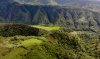
This is a dramatic landscape and the consequence of flight failure would be challenging to resolve, to say the least. Unexpected opportunities regularly occur as you cannot know how the land is configured until in the air cruising overhead. To give you some idea of scale many of the trees in this landscape are 80-100' tall and the MA is about 300m above the green field to the lower left.
Attachments
Former Member
Well-Known Member
I shoot both and keep recording for the entire flight, chopping off the 'dead wood' later. For the most part I am not flying to a script, although some of the scenery is so outstanding I will first reconnoiter the area and determine the best way to fly it and then capture the footage I want with as many takes as are required.
This is a dramatic landscape and the consequence of flight failure would be challenging to resolve, to say the least. Unexpected opportunities regularly occur as you cannot know how the land is configured until in the air and cruising overhead. To give you some idea of scale many of the trees in this landscape shot are 80-100' tall.View attachment 60895
Beautiful. Looks like it was worth the climb, but thats easy for me to say sitting in a chair in my living room.
Beautiful. Looks like it was worth the climb, but thats easy for me to say sitting in a chair in my living room.
That pic is just the 'hills' around where I'm staying, they average 1,000' elevation. These pics are of the vocano.


If the comparisons were between actual heading based on VLOS vs radar, difference could be due to mobile device compass being out of calibration. I always have to do the figure 8 dance if I want an accurate compass reading from a mobile device.
You usually don't notice on maps like Google because they can calculate your actual heading based on your movements and resulting change in GPS coordinates.
You usually don't notice on maps like Google because they can calculate your actual heading based on your movements and resulting change in GPS coordinates.
I fly air gap using Crystalsky, also calibrated whenever the MA asks for it. It would be very helpful for DJI to weigh in on the topic of the longstanding MA compass issue since everything else thus far are only guesses. If it's a hardware flaw that can't be fixed we need to know.
I also find I have to calibrate every time I fly wether I'm at the beach or out in the country. When I had a spark prlor to getting the air I only ever calibrated once when I first got it, I love the air but it is annoying having to do this every time I fly why don't dji fix this problemI fly air gap using Crystalsky, also calibrated whenever the MA asks for it. It would be very helpful for DJI to weigh in on the topic of the longstanding MA compass issue since everything else thus far are only guesses. If it's a hardware flaw that can't be fixed we need to know.
I hope you guys livestream or cache your videos. If not, and your drone goes by bye, all you will have left is a memory and a hole in your pocket lol
LOL
Rog42
Member
- Joined
- Dec 4, 2017
- Messages
- 10
- Reactions
- 8
- Age
- 56
Yep - I've had the Aie for over a year now, flown it in Wales (UK), and New South Wales where I live (Australia) - and every. single. flight. I need to calibrate compass. Also, the wifi broadcast signal is pathetically weak compared even to the Spark.
I had a Spark, and also fly the Mavic Pro (1) - both of which are great to launch and with fantastic connectivity throughout flight...
I had a Spark, and also fly the Mavic Pro (1) - both of which are great to launch and with fantastic connectivity throughout flight...
Mavić_Legenda
Active Member
- Joined
- Apr 25, 2017
- Messages
- 42
- Reactions
- 27
Yep, MA is basically unusable in CE mode through Australia. Changing to FCC mode (+/- 3rd party antenna) certainly fixes the connectivity, except that your average flyer probably won’t be aware of how to do thisYep - I've had the Aie for over a year now, flown it in Wales (UK), and New South Wales where I live (Australia) - and every. single. flight. I need to calibrate compass. Also, the wifi broadcast signal is pathetically weak compared even to the Spark.
I had a Spark, and also fly the Mavic Pro (1) - both of which are great to launch and with fantastic connectivity throughout flight...
Cut.Aussie
Well-Known Member
- Joined
- Apr 1, 2017
- Messages
- 501
- Reactions
- 207
- Age
- 70
Similar threads
- Replies
- 4
- Views
- 1K
- Replies
- 3
- Views
- 566


DJI Drone Deals
1. Mini 2
2. Mini 3 Pro
3. Mini 4 Pro
4. Air 2s
5. Air 3
6. Avata 2
7. Mavic 3 Pro
8. Mavic 3 Classic
2. Mini 3 Pro
3. Mini 4 Pro
4. Air 2s
5. Air 3
6. Avata 2
7. Mavic 3 Pro
8. Mavic 3 Classic
New Threads
-

-

-
-
Hello everyone! New aspiring drone pilot here, from Portugal.
- Started by Rui S
- Replies: 5
Forum statistics
