DJI Mavic, Air and Mini Drones
Friendly, Helpful & Knowledgeable Community
Join Us Now

New Guy In Charge of SAR Drone Program

Winston Bull

Well-Known Member
Joined
Mar 12, 2019
Messages
54
Reactions
44
Age
58
Location
Santa Rosa, CA
So…I must have missed a meeting or something, because someone suddenly put me in charge. As a result, I am looking for a lot of information and answers.

Who we are: a county Search & Rescue operation under SO auspices in Northern CA. We have apparently had this drone program for a couple of years, but have never used it on a search, nor have we really trained with it. It is clear to me that the drone will frequently NOT be the best tool in the box, but there will certainly be times when it can either help find someone, or will be helpful in keeping a team safe.

What we have: M2ED with (supposedly) up-to-date apps, software, and databases running on a large CrystalSky. Bird has all of four batteries. No goggles currently

What I am hoping to learn—
  1. Where is a good source of intel on how to set up a SAR drone program? Even though we have on set up conceptually, I want to approach this from the ground up, starting with the basics
  2. I have read the various manuals on the bird, on DJI Pilot and other DJI stuff. BUT….I am still desperately looking for descent, in-depth tutorials on how to read thermography for SAR on that specific bird. I am having problems getting my settings dialed In, including trying to find the “IsoTherm” setting that numerous people have mentioned in 3-minute videos: it simply isn’t showing up on my menus, even though I know the software is up-to-date.
  3. How many batteries is a good number to have for such an operation?
  4. how do you square the notion that you should not keep batteries charged all the time with the notion that for SAR you need to be ready to go at a moment’s notice?
  5. What are some good training exercises to do—either with or without a VO?
    1. day training
    2. night training
  6. Would one recommend getting a pair of goggles? (We used them (borrowed) in the one mission we had, an evidence search, and as best as I could tell they were moderately helpful.)
This is a lot to ask, but I am desperate to get this up and running. We also have an annual night training in a couple of weekends (11/12/2022) so I’d be eager to be operational by then to any extent.

If this is something better posted elsewhere please let me know.
Thanks
 
  • Like
Reactions: BigAl07
There are a couple people here that either currently do SAR or have done it in the past. @BigAl07 and @Meta4 spring to mind. As far as the thermal goes, FLIR runs a certification program I believe but whether or not that would be useful for SAR, I'm not sure. Generally, goggles are a no-no and it's helpful to have a large display that your feed can be sent to as it gives more eyes on the search part while you concentrate on the flying part. This is all my 2 cents worth and either of the two mentioned above (or others that do SAR on here) might have better/different ideas.
 
@Winston Bull drop me a PM and we can dig into this with you. That's a LOT of information to try and put into a single forum post.

I'm credentialed at the local (county) and State (NC) level with Emergency Services and I've been doing "UAS SAR" for several years now. I'm confident we can help on several of your questions and I have other resources I can pass along in topics I'm not "fluent" in.
 
While I appreciate that some info will need to be off line, I would like to get some of this knowledge shared as appropriate from those with experience. I just started my first night flights in shielded terrain and it feels like flying as a beginner again.

My first comments are: the RC, even on minimum brightness, really messes with your natural night vision and closing one eye is really not a long term option. The RC screen is small enough to miss thermal details you can see on a larger screen. I got a compass recalibration demand before I could take off even though I was gtg in the same spots in the day with vision assistance. Knowing the relative altitude of nearby obstacles is helpful to focus on the thermal image rather than the flight instruments. I started very simply by running the machine up and landing with lights and no lights to get a feel for it, like IFR you need to start trusting your instruments. I then set a max distance at 100m to start searching for rabbits and deer.
 
There are a couple people here that either currently do SAR or have done it in the past. @BigAl07 and @Meta4 spring to mind. As far as the thermal goes, FLIR runs a certification program I believe but whether or not that would be useful for SAR, I'm not sure. Generally, goggles are a no-no and it's helpful to have a large display that your feed can be sent to as it gives more eyes on the search part while you concentrate on the flying part. This is all my 2 cents worth and either of the two mentioned above (or others that do SAR on here) might have better/different ideas.
Thank you, MavicAir2Marc. I think I will definitely be putting this on a big screen any time I can: I need to show folks that this is a good tool to use when the job is right!
 
  • Like
Reactions: MavicAir2Marc
I oversee the drone program for a law enforcement agency. Much of the work we do is similar to GSAR work (looking for someone, but ours often do not want to be found) and we occasionally do drone work with the local GSAR group as they do not have any drones. We primary use Mavic Enterprise drones and have Duals, Zoom, and Advanced models in our fleet.

I'll try to answer some of your questions and pass on some observations.

The more batteries you have, the better. What you have for a charging setup will determine how many you should have, as you should have enough to stay in the air as much as possible. The local GSAR have a small generator I use to charge batteries and I also have access to a power inverter that plugs into a cigarette lighter socket. Some inverters may not work, some are very slow. We have purchased some aftermarket chargers that charge 3 batteries at a time for quicker charging. I have a spare charged smart controller with me to swap out and have had a charging cable plugged into the smart controller to charge it while flying.

As far as the issue of needing batteries at or near fully charged when it is not good for them, we just deal with it. We set our batteries to the longest discharge (10 days) and about every 2 days unplug and plug them back in to maintain a near full charge. This is very hard on the batteries and we have had a number swell up that we have had to take out of service. We check batteries frequently for swelling, and trash any that do, and replace them. Not cheap, but the cost of doing business.

Where possible, assign one person per drone to ensure that batteries, controllers, and other items are charged, well maintained, and up to date. Our pilots keep their work drones at home when off duty and look after them. Make sure that you have extra cords and other items available. We have had several instances where a pilot could not fly in an urgent situation due to a cord failure.

Stick time and training are the key. Flying at night is very different than flying during the day. We train both day and night using persons both wanting to be found and trying to hide. We often use the spotlight at night. It stays off until something of interest is seen on the FLIR, then the pilot descends with the light on, switching to visual, until the item/person is identified.

The Advanced records visual and FLIR at the same time and I was amazed at how, on a warm, sunny day, I was able to track another officer using the FLIR, while he walked along a fairly heavily wooded path. When I played the recordings, I only saw him once, very briefly visually, but saw him over half the time during the three minute walk on the FLIR.

One night, while assisting another police agency look for a suicidal male, I directed officers on the ground towards a heat signature in a heavily wooded area. It kept moving when they got close. They finally got close enough to see in their flashlight beams that it was a wolf that they had been chasing. I was embarrassed, but it showed that the FLIR worked well.

The smart controller has an HDMI out port and I usually bring a 21" monitor that I plug into it that can be monitored by a GSAR member giving me a second set of eyes on a bigger screen. I have a 50' HDMI cord that I have run to a monitor in the GSAR command post and there are wireless options to transmit video from the smart controller to the command post.

When working with GSAR, they usually assign me to check steep cliffs along the shoreline, swamps, and other areas that they cannot easily access on foot. They are very interested in knowing exactly what area was covered by the drone. I synch my flights in Airdata, which enables me to convert each flight to a .gpx file, which is the mapping system our GSAR uses. They are able to upload all of my flights onto their map to see what has been overflown. Very handy when you have multiple drones at a scene.

Bear in mind that pilots will need a break. While searching for three teenagers who had drowned when a boat capsized, I flew for almost 3 hours straight. By the end I was exhausted, and badly needed a break. For longer deployments, you may need several pilots.

For LEO and GSAR work, lives may be at stake, so we often have to fly in conditions that are not the best. Wind is a big factor where I am at. The rule is that if you have to fly in any kind of wind, try to position yourself so you are initially flying into the wind, and then with the wind on the return flight.

Good luck with your program. We have had some great success with the drone program, and the costs are much less than utilizing helicopters or other alternatives. While drones are great tools, they will never replace boots on the ground.

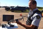
Photo and link from search we did with GSAR in 2020. I am holding a Enterprise Zoom, good for day time searches. You can see the monitor and that the smart controller is charging.

DSC_0643_svyW82M.jpg
 
Last edited:
  • Like
Reactions: MavicAir2Marc
Lycus Tech Mavic Air 3 Case

DJI Drone Deals

New Threads

Forum statistics

Threads
130,953
Messages
1,558,282
Members
159,953
Latest member
BRUNO.CARDOSO