DJI Mavic, Air and Mini Drones
Friendly, Helpful & Knowledgeable Community
Join Us Now

New Regulations? Where can I fly?

ccurry

Well-Known Member
Joined
May 3, 2018
Messages
79
Reactions
21
Hello,

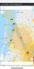
With the new rules, regulations and laws coming down the pipeline and or newly implemented. I was curious as to where I can actually fly legally. I just purchased a Mavic Zoom again and before I open the box I would like to understand the zones better before use. I use to fly care free as long as I stayed outside of red and blue zones in my area but I don’t know what to think now. The last thing I want is a paperweight of a drone. Here is an attached screenshot of my general area. I mainly want to know if I can fly in warning and enhanced warning zones still with the new regulations. If someone could enlighten me on this I would be grateful and you would help a worried mind.

Thank you.
 

Attachments

  • 0919DA8F-1290-4712-8C90-8B8D3C6F739D.jpeg
    0919DA8F-1290-4712-8C90-8B8D3C6F739D.jpeg
    526.9 KB · Views: 294
  • Like
Reactions: jay1200
Are you flying as a hobbyist or under Part 107 rules?
 
As of today, you can:
  • Fly up to 400 AGL in uncontrolled airspace (Class G).

  • Fly in authorized fixed sites within controlled airspace (Classes B, C, D, and E). Fixed sites are marked with blue dots on the map of FAA UAS data linked here.
Also, you need to stay clear of restricted airspace. Those areas can be found on map of FAA UAS data linked here.
 
Thank you for your quick reply, I really appreciate it. Based on the map I provided would I be ok flying in a yellow or orange zone? I marked a few places I typically have flown in the past.
 

Attachments

  • FC61D12B-8295-45BE-B0D8-709FD75F0960.jpeg
    FC61D12B-8295-45BE-B0D8-709FD75F0960.jpeg
    512.3 KB · Views: 134
According to the FAA USA data map, you cannot fly in any of the locations within these boxes:

1558282278791.png
 
  • Like
Reactions: brandon 1
I understand now, and thank you again. So bottom line the green boxes are off limits according to FAA data map. Does this include the new regulations or will those change the map? Sorry if that’s an odd question.
 
The green boxes represent controlled airspace. With the exception of the fixed sites in those locations, those locations are currently off limits to hobbyists since there is no way to get FAA authorization to fly there. At some point in the future, you'll be able to get authorization through LAANC.
 
Thank you again, so it sounds like I am clear to fly in the areas I designated on the attached map, with the exception of the blue areas. Why does DJIs map look different than the FAAs? I’m seeing some major differences. Can I fly legally in a warning and enhanced warning zone from DJIs map or is that the technically within the 5 miles and is a no go? Thank you again, for your help.
 

Attachments

  • 2F9407C6-5C1C-4EDA-B01D-A6D4333C1408.jpeg
    2F9407C6-5C1C-4EDA-B01D-A6D4333C1408.jpeg
    512.3 KB · Views: 94
Can I fly legally in a warning and enhanced warning zone from DJIs map or is that the technically within the 5 miles and is a no go?
DJI's map is not showing you where you can legally fly. It's only showing you locations where your drone will not fly or where you need authorization from DJI to fly. The fact that DJI authorizes you to fly and/or your drone is technically able to take off and fly does not mean you're in a location where it's legal to fly. Always consult an official FAA map before heading out to fly in new locations.
 
Ok, one last question. I can’t fly within the green boxes understood, but I can fly outside of them. What if I’m only 3-4 miles away from a green box and not 5 miles? Is that ok?
 
I realize that was a dumb question. I’m just confused is it 5 miles from the airport or 5 miles from controlled airspace? Or is controlled airspace within the 5 miles? Maybe I’m overthinking this.
 
Ok, one last question. I can’t fly within the green boxes understood, but I can fly outside of them. What if I’m only 3-4 miles away from a green box and not 5 miles? Is that ok?
Distance from a "green box" is of no concern. You are either in one of those grid boxes (restricted) or not in one of them (not restricted). As @msinger pointed out, the DJI Geo Fencing maps are not what you should be looking at. They become important only to know if you need a DJI Zone Unlock in order to start and fly the drone there. In many cases they are more restrictive than the FAA airspace maps, and for good reason! They keep you out of trouble by restricting your flight in potentially hazardous areas (like final approach for a runway, published VFR airways, IFR glideslopes, etc...).
Where you can legally fly as per FAA regulations is determined by the NAS and the associated FAA maps (as pointed out again by @msinger).

Generally as a rookie recreational pilot, what I would recommend is:
  • Use the FAA Facilities Map to make sure you can fly in a given location
  • Look up the location in AirMap before the flight. You want to make sure not only that the airspace is not restricted in general, but also that there are not TFRs in place when you want to fly.
  • If the Geo Fencing prohibits you from flying there, then leave it at that and move somewhere else. At least until you get a thorough understanding of how the NAS works.
 
Thank you again, I greatly appreciate your help. What is class G airspace and what would be the best way to determine that? Through the faa site?
 
Ok. So anything inside in the green boxes or red boxes is controlled airspace, otherwise it’s class G airspace. I have an small air park near my home but it isn’t listed as controlled on the faa map, so that is concerning.
 

Attachments

  • 924DB0CC-D4F5-4FCC-BBFD-1D3A45115812.jpeg
    924DB0CC-D4F5-4FCC-BBFD-1D3A45115812.jpeg
    1.6 MB · Views: 40
Last edited:
Perhaps I'm uninformed, but it is my understanding that one can fly in the area covered by those squares as long as one stays below the AGL level noted in the box. In other words, the controlled airspace starts at the altitude shown in the box. If the box has '200' in it, one can fly so long as the aircraft stays below 200' AGL. It is my understanding that that is the purpose of the numbers in the boxes. Am I wrong?

Nick
 
it is my understanding that one can fly in the area covered by those squares as long as one stays below the AGL level noted in the box. In other words, the controlled airspace starts at the altitude shown in the box.
You are correct. However, one first must get FAA authorization through LAANC before flying in those boxes. As of today, only Part 107 pilots can use LAANC to get FAA authorization.
 
  • Like
Reactions: strdr
I appreciate the response, but your answer is not so clear. LAANC clearance is required for flying in controlled airspace and it is my understanding that the purpose of the numbers in those boxes is to indicate the height of the bottom of the controlled airspace. In other words, class G airspace exists under the height indicated in the box and clearance is not required to fly in class G airspace.

Nick
Hi Nick,

No that is not correct. The US Facilities Map shows you the maximum altitude to which LAANC clearance will be be granted if you need to fly in that airspace.
To know the actual airspace classification, you need to look at the VFR Sectional Chart for that area.
What you will typically see is that there may be a large area of restricted Class B airspace around a major airport. That airspace is from ground to some specified height. Restricted. Not class G. It is Class B. No recreational flights anywhere in that area (for now).
Then you look at the Facilities Map and see the grid which overlays and matches the same Class B airspace. The individual grid boxes state the maximum altitude to which LAANC authorization may be granted (right now only to Part 107 pilots).
 
Lycus Tech Mavic Air 3 Case

DJI Drone Deals

New Threads

Forum statistics

Threads
130,994
Messages
1,558,709
Members
159,982
Latest member
PetefromNZ