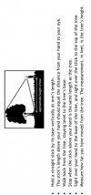
So lets say I want determine the height of a tall palm tree. Standing next the the tree, fly vertically until the top is in the center of the view finder. But how low does it need to be to just clear it? Bottom 1/3rd? Totally out of the viewfinder?
Palm trees are bushy at the top, you cant really tell from VLOS. I know, when in doubt, fly higher but that's not what I am trying to accomplish, I want to know what the actual hight of the tree is using the drone. Or any tall object for that matter. Lots of lamp posts in my neighborhood.
First I would learn to fly about a 2 ft over the water , you will notice that this is tricky enough , but this will teach you quickly how far from the water is comfortable after 50 ft out .. let Say 3 Ft for the next couple hundred feet and what you will find is that you will be smart to in gradually keep lifting up as you go further out.
Now that you survived that Water Skimming , and gotten the feeling of being able to trust your drone or NOT !
Once you see how difficult it is on the water where you have perfect line of sight, that will determine quickly the skills and challenge and Vantage point needed to be successful at the Art of Skimming the Tree Tops .
Even with that training , you need a few things to Tree Top Fly , as it something we do a lot of .
Take notice to how the flight allows me to gain perspective of the trees before the attempt to fly over them.
You can do this same thing by flying next to the tree line and finding your incline over the top .
Once you learn that trick it will be much easier with some practice to do this.
Today of course we just race out over the top of the trees now as seen in other our other videos.
Trust in your drone :
A good vantage point from which to see the drone .
A good vantage point to see clearly your distance from the Tree tops
A gradual incline up the further you go out.
Notes of how far you went before a gradual incline .
You might even consider getting the Rescue Jacket to save you from your mistakes.
Phatnomrain.org
Gear to fly in the Rain. Land on the Water.