

I have been using Airmap.com for automated authorization for flying. In anticipating a photo shoot for a client, I filed a flight plan with Airmap.com, and the request was denied, because I was in close proximity to the San Jose, CA airport. My response was to tell the client I may not be able to fly due to the airspace restriction. Airmap shows a height restriction of zero feet in the area I was in. While I was able to get the ground based photos for the client, and some height with a ladder, the client told me that they previously hired a videographer to photograph the property. I'm assuming that pilot must have obtained authorization. I just filed a request form on FAADroneZone to see if I can schedule authorization for a future date. But even with authorization my Mavic Air gives me a message saying unable to fly because I'm in restricted air space. So even with authorization, how would I fly? Any advice or comments appreciated.

You are using an out of date browser. It may not display this or other websites correctly.
You should upgrade or use an alternative browser.
You should upgrade or use an alternative browser.
Obtaining authorization in a controlled airspace
- Thread starter Treve
- Start date
usrmesarge
Active Member
I think somebody wasnt utilizing a drone with DJI apps, and maybe endangering others. But I could be wrong here.
Mazdaman323lx
Well-Known Member
Tufargon
Well-Known Member
PhantomFandom
Well-Known Member
You will need to apply on the DJI Unlock Website for an authorization to fly. Use the FAA authorization (that you get from DroneZone) as the documentation that DJI requests.I have been using Airmap.com for automated authorization for flying. In anticipating a photo shoot for a client, I filed a flight plan with Airmap.com, and the request was denied, because I was in close proximity to the San Jose, CA airport. My response was to tell the client I may not be able to fly due to the airspace restriction. Airmap shows a height restriction of zero feet in the area I was in. While I was able to get the ground based photos for the client, and some height with a ladder, the client told me that they previously hired a videographer to photograph the property. I'm assuming that pilot must have obtained authorization. I just filed a request form on FAADroneZone to see if I can schedule authorization for a future date. But even with authorization my Mavic Air gives me a message saying unable to fly because I'm in restricted air space. So even with authorization, how would I fly? Any advice or comments appreciated.

Not necessarily talking about a drone pilot.I have been using Airmap.com for automated authorization for flying. In anticipating a photo shoot for a client, I filed a flight plan with Airmap.com, and the request was denied, because I was in close proximity to the San Jose, CA airport. My response was to tell the client I may not be able to fly due to the airspace restriction. Airmap shows a height restriction of zero feet in the area I was in. While I was able to get the ground based photos for the client, and some height with a ladder, the client told me that they previously hired a videographer to photograph the property. I'm assuming that pilot must have obtained authorization. I just filed a request form on FAADroneZone to see if I can schedule authorization for a future date. But even with authorization my Mavic Air gives me a message saying unable to fly because I'm in restricted air space. So even with authorization, how would I fly? Any advice or comments appreciated.
You can't LAANC here, you would have to part 107 for whatever the airspace is.
brett8883
Well-Known Member
When you get the authorization you’ll have to get an unlock from DJI which isn’t hard.I have been using Airmap.com for automated authorization for flying. In anticipating a photo shoot for a client, I filed a flight plan with Airmap.com, and the request was denied, because I was in close proximity to the San Jose, CA airport. My response was to tell the client I may not be able to fly due to the airspace restriction. Airmap shows a height restriction of zero feet in the area I was in. While I was able to get the ground based photos for the client, and some height with a ladder, the client told me that they previously hired a videographer to photograph the property. I'm assuming that pilot must have obtained authorization. I just filed a request form on FAADroneZone to see if I can schedule authorization for a future date. But even with authorization my Mavic Air gives me a message saying unable to fly because I'm in restricted air space. So even with authorization, how would I fly? Any advice or comments appreciated.
Deleted Member 997
Well-Known Member
- Joined
- Sep 17, 2020
- Messages
- 156
- Reactions
- 103
Makes me regret buying DJI now. I can get authorizations to fly since I know everyone and can talk to towers. But my airframe shuts me down. Their has to be a fix
usrmesarge
Active Member
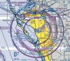
Hope I'm posting this in the right area. Have a question about this sectional chart in my area. What is the outer band the encircles SRQ flight airspace (band with tick marks and numbers)? is that the indicated altitude when approaching the SRQ airspace?
Attachments
Deleted Member 997
Well-Known Member
- Joined
- Sep 17, 2020
- Messages
- 156
- Reactions
- 103
That's for manned A/C, it's for the VORHope I'm posting this in the right area. Have a question about this sectional chart in my area. What is the outer band the encircles SRQ flight airspace (band with tick marks and numbers)? is that the indicated altitude when approaching the SRQ airspace?
Deleted Member 997
Well-Known Member
- Joined
- Sep 17, 2020
- Messages
- 156
- Reactions
- 103
The magenta solid rings are your Class Airspace floor and ceiling at 5NM and 10NMHope I'm posting this in the right area. Have a question about this sectional chart in my area. What is the outer band the encircles SRQ flight airspace (band with tick marks and numbers)? is that the indicated altitude when approaching the SRQ airspace?
Your 5nm is the inner band surface to 4k feet, outside of the 5 is 1200 to 4k feet with a 10 NM radius. The blue dotted is for the VORHope I'm posting this in the right area. Have a question about this sectional chart in my area. What is the outer band the encircles SRQ flight airspace (band with tick marks and numbers)? is that the indicated altitude when approaching the SRQ airspace?
Deleted Member 997
Well-Known Member
- Joined
- Sep 17, 2020
- Messages
- 156
- Reactions
- 103
Then you have class E under that...Hope I'm posting this in the right area. Have a question about this sectional chart in my area. What is the outer band the encircles SRQ flight airspace (band with tick marks and numbers)? is that the indicated altitude when approaching the SRQ airspace?
Deleted Member 997
Well-Known Member
- Joined
- Sep 17, 2020
- Messages
- 156
- Reactions
- 103
What's your question?Hope I'm posting this in the right area. Have a question about this sectional chart in my area. What is the outer band the encircles SRQ flight airspace (band with tick marks and numbers)? is that the indicated altitude when approaching the SRQ airspace?
Deleted Member 997
Well-Known Member
- Joined
- Sep 17, 2020
- Messages
- 156
- Reactions
- 103
Everything i told you is in your Key on the front of the sectional ?Hope I'm posting this in the right area. Have a question about this sectional chart in my area. What is the outer band the encircles SRQ flight airspace (band with tick marks and numbers)? is that the indicated altitude when approaching the SRQ airspace?
Makes me regret buying DJI now. I can get authorizations to fly since I know everyone and can talk to towers. But my airframe shuts me down. Their has to be a fix
It's actually a very simple process to unlock your drone once you get permission. You can find the answers here: Fly Safe – Drone Flying Tips, Policies & Regulations, and More – DJI
Also, you can't take to towers anymore. You have to obtain permission from either a LAANC provider or via the Drone Zone.
Hi Vic,It's actually a very simple process to unlock your drone once you get permission. You can find the answers here: Fly Safe – Drone Flying Tips, Policies & Regulations, and More – DJI
Also, you can't take to towers anymore. You have to obtain permission from either a LAANC provider or via the Drone Zone.
I recently saw the episode on DU where you explain how to get an authorization to fly in control air space. Is there a site that provides some sort of script to be able to get a six month authorization in certain control their spaces? I have been doing jobs for Dronebase that at this time did not require permissions, I live in New York city, and want to be able to have the authorization in place when the next job comes through and requires it. I also do jobs in Florida and New Jersey . Thank you in advance for your help and that episode was very informative. Love drone U
D
Deleted member 114292
Guest
I just asked for six months and got it.Hi Vic,
I recently saw the episode on DU where you explain how to get an authorization to fly in control air space. Is there a site that provides some sort of script to be able to get a six month authorization in certain control their spaces? I have been doing jobs for Dronebase that at this time did not require permissions, I live in New York city, and want to be able to have the authorization in place when the next job comes through and requires it. I also do jobs in Florida and New Jersey . Thank you in advance for your help and that episode was very informative. Love drone U
Just asking, are you a licensed Part 107 pilot?I have been using Airmap.com for automated authorization for flying. In anticipating a photo shoot for a client, I filed a flight plan with Airmap.com, and the request was denied, because I was in close proximity to the San Jose, CA airport. My response was to tell the client I may not be able to fly due to the airspace restriction. Airmap shows a height restriction of zero feet in the area I was in. While I was able to get the ground based photos for the client, and some height with a ladder, the client told me that they previously hired a videographer to photograph the property. I'm assuming that pilot must have obtained authorization. I just filed a request form on FAADroneZone to see if I can schedule authorization for a future date. But even with authorization my Mavic Air gives me a message saying unable to fly because I'm in restricted air space. So even with authorization, how would I fly? Any advice or comments appreciated.
Yes Licensed.Just asking, are you a licensed Part 107 pilot?
Is there a place that has scripts to help get aprrovals, a format to go by?I just asked for six months and got it.
Similar threads
- Replies
- 11
- Views
- 620
- Replies
- 3
- Views
- 974
- Replies
- 16
- Views
- 1K
- Replies
- 13
- Views
- 2K
- Replies
- 3
- Views
- 656


DJI Drone Deals
1. Mini 2
2. Mini 3 Pro
3. Mini 4 Pro
4. Air 2s
5. Air 3
6. Avata 2
7. Mavic 3 Pro
8. Mavic 3 Classic
2. Mini 3 Pro
3. Mini 4 Pro
4. Air 2s
5. Air 3
6. Avata 2
7. Mavic 3 Pro
8. Mavic 3 Classic
New Threads
-

-
-
-

-
Air 3 Calp ( Spain ) Amazing rock and err ? SeaGulls
- Started by Pacefast
- Replies: 5
Forum statistics
