DJI Mavic, Air and Mini Drones
Friendly, Helpful & Knowledgeable Community
Join Us Now

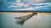
Air 2s Outer banks Fishing Pier - a little crooked

Has it ever been hit by anything large? Looking at the overhead it almost looks as if it has been hit and bowed in 2 places.
Plus there is a width change. The outer third of the walkway is wider, with most of the additional width being on the bottom-of-the-picture side.
 
  • Like
Reactions: FASTFJR
Here are some pictures of the Outer Banks fishing pier in North Carolina. It’s amazing how crooked this fishing pier is. Gets beat up pretty bad by the hurricanes.

View attachment 137206View attachment 137207
Location in OBX? Love flying there and hope to be back in a few weeks. Lots of places to fly and sadly - way too many restrictions, esp on the southern end of Hatteras Island. Most of it is restricted NP, so finding take-off and landing spots outside the zone is a trick.

There is / was a beached fishing boat down by Oregon Inlet that I missed droning the last time we were there. Got land pics as it slowly gets covered over in sand, but a good above the boat shot with a drone would be the best. Also kite surfers like that area too.
 
Has it ever been hit by anything large? Looking at the overhead it almost looks as if it has been hit and bowed in 2 places.
Plus there is a width change. The outer third of the walkway is wider, with most of the additional width being on the bottom-of-the-picture side.
Yes, its been hit by lots of large waves, a bunch of hurricane and debris from other broken piers

The only real straight pier is Jennettes which has concrete pilings


Nags Head pier isn't much better......

 
  • Like
Reactions: mreservices
Location in OBX? Love flying there and hope to be back in a few weeks. Lots of places to fly and sadly - way too many restrictions, esp on the southern end of Hatteras Island. Most of it is restricted NP, so finding take-off and landing spots outside the zone is a trick.

There is / was a beached fishing boat down by Oregon Inlet that I missed droning the last time we were there. Got land pics as it slowly gets covered over in sand, but a good above the boat shot with a drone would be the best. Also kite surfers like that area too.

This is the Outer Banks fishing pier in South Nags Head. You can takeoff near the fishing pier but you can’t go across the street or you’re into national seashore. I know the fishing boat you’re talking about.I saw it last year and then again this year. Although this year I saw it as we were driving down 12 towards Hatteras. I don’t know how covered in sand it is now but you can still see it from the road so I assume not too bad. I have seen some nice pictures with night sky and the wreck. I would’ve loved to of flown it but it falls under the national seashore and you can’t. Pretty much anything south of Nags Head you’re screwed.
 
  • Like
Reactions: tlswift58
Yes, its been hit by lots of large waves, a bunch of hurricane and debris from other broken piers

The only real straight pier is Jennettes which has concrete pilings


Nags Head pier isn't much better......

Definitely been hit by a lot of waves during hurricanes. I assume the difference in width is based on the lumber size when they did repairs. I would’ve assumed they made it all the same but probably things change over the years. Did not know about it being hit by other debris but it doesn’t surprise me. Jeanettes pier was originally wood and had issues too. Then they tore it down and built the concrete pier that stands today. Should last for a long time. It really is an incredible fishing pier.
 
This is the Outer Banks fishing pier in South Nags Head. You can takeoff near the fishing pier but you can’t go across the street or you’re into national seashore. I know the fishing boat you’re talking about.I saw it last year and then again this year. Although this year I saw it as we were driving down 12 towards Hatteras. I don’t know how covered in sand it is now but you can still see it from the road so I assume not too bad. I have seen some nice pictures with night sky and the wreck. I would’ve loved to of flown it but it falls under the national seashore and you can’t. Pretty much anything south of Nags Head you’re screwed.
Sadly, yes much of the southern end is Nat Park, but there are stretches near Oregon Inlet that is outside of the boundaries. I've looked on Aloft and B4UFLY and would recheck if I did try and drone down that way. Could possibly even hit Bodie Island Lighthouse as well. I did Bodie before I knew the rules and it was empty of people at sunset in fall.

I flew over Jockeys Ridge SP as well, capturing some of the want to be hang gliders trying to learn. Took off across the street in a public parking area and kept to the outside edges as did not want to get close to the gliders, even though most got maybe 30-40 ft off the ground for like 10 seconds.

Also flew up on Carova 4x4 beach, which was fun. Did not get anything with the wild horses - too early in the day for them to come to the beach.

We typically stay in Kill Devil Hills and may be headed back in a few weeks. Lower price hotels and way less people.
 
..
These piers were build by the Reforming Alcoholics First Baptist Church Community Group, they were abysmal reformers.

Ha ....was expecting a "crooked" horizon ...but nice surprise.
Cheers mate from Down Under

Ha ha, I was looking for that too, before clicking thinking well straighten it up in a photo editor ! Lol.

Very nice shots.
 
Lycus Tech Mavic Air 3 Case

DJI Drone Deals

New Threads

Forum statistics

Threads
130,955
Messages
1,558,300
Members
159,957
Latest member
roligtroll