DJI Mavic, Air and Mini Drones
Friendly, Helpful & Knowledgeable Community
Join Us Now

Panorama mode with DNG in the Mini 2

mkjo

Member
Joined
Aug 6, 2017
Messages
9
Reactions
1
Age
123
Hi together,
some forum answers and other resources are a little bit unclear to me, so I ask it again.

The mini 2 supports DNG, which is great, because I can improve the image quality a lot in the post processing.

I didn't fine a way to save DNG files for the Quickshot Pano modes. Am I to stupid to enable DNGs for Pano Quickshots, or did they removed this feature in current firmwares?

Thanks in advance for your help,
 
Every single mode (Photo/Video/Pano/Quickshots) has its own settings. So even if you set RAW/DNG in the Photo mode, settings for Panoramas are separate, you have to go to the Panorama mode (while flying!) and then to the settings and choose RAW.
 
  • Like
Reactions: rcb
Hi together,
some forum answers and other resources are a little bit unclear to me, so I ask it again.

The mini 2 supports DNG, which is great, because I can improve the image quality a lot in the post processing.

I didn't fine a way to save DNG files for the Quickshot Pano modes. Am I to stupid to enable DNGs for Pano Quickshots, or did they removed this feature in current firmwares?

Thanks in advance for your help,
I seldom use the panorama mode with my Mavic 2 Pro. I put the drone up where I want to shoot the scene, and take anywhere from 3 to 5 images, overlapping each image 30% (1/3rd). I shoot in RAW (DNG). I take these images into Adobe Photoshop CC 2021. Open them in Adobe Camera RAW. Select all (CTRL+A). Right click on the first image and you will get a drop down menu with the option to choose "Merge to Panorama." Let the computer do the work. Then , it will fill in the blank spots with the dialogue box selections. (experiment with this). Once you have your final image, you can take that image into Adobe Camera Raw again and edit it. Here is an example I did recently with this technique.
 

Attachments

  • Biltmore Hotel-Panorama.jpg
    2 MB · Views: 30
I seldom use the panorama mode with my Mavic 2 Pro. I put the drone up where I want to shoot the scene, and take anywhere from 3 to 5 images, overlapping each image 30% (1/3rd). I shoot in RAW (DNG). I take these images into Adobe Photoshop CC 2021. Open them in Adobe Camera RAW. Select all (CTRL+A). Right click on the first image and you will get a drop down menu with the option to choose "Merge to Panorama." Let the computer do the work. Then , it will fill in the blank spots with the dialogue box selections. (experiment with this). Once you have your final image, you can take that image into Adobe Camera Raw again and edit it. Here is an example I did recently with this technique.

great stuff!
enjoyed browsing your smugmug gallery!
any problems launching the drone in the everglades?
best launch site?
does the M2Pro have pre-programmed pano quick shots?
thanks!
 
great stuff!
enjoyed browsing your smugmug gallery!
any problems launching the drone in the everglades?
best launch site?
does the M2Pro have pre-programmed pano quick shots?
thanks!
I drive out Tamiami Trail going west and you will start to see pull offs as you approach the Shark Valley entrance. On the the right of the road are numerous boat ramps and a canal. Lots of fisherman there too. I fly NORTH away from the park. I am not up in the air more than 20-30 seconds and I do not go very high (I keep it less than 160 feet). My clips are never more than 3-7 seconds so I have a little extra for editing. I have not gotten up my nerve to follow an air boat ride. There are several Miccosukee villages with airboats and refreshments on the left side (South side) of the road.

The M2 Pro has all of the pano options (180 degrees, 360 degrees, etc). Be sure to save your files in RAW for post processing.

thanks for great info!
did you really mean, "...not up in the air more than 20-30 seconds..."?!
that's a very short flight!
 
thanks for great info!
did you really mean, "...not up in the air more than 20-30 seconds..."?!
that's a very short flight!
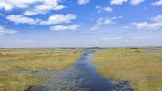
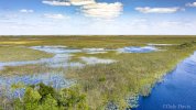
No, let me correct that! I'll take off from the highway pull off, put the drone up about 25-30 feet (the Sea of Grass has nothing taller, usually unless there is a Hammock). I'll try to follow one of the waterways and film for about 5-10 minutes. Then I stop, switch from video to stills, take some shots, then back to video for the trip back to the road. The entire round trip is about 5-10 minutes. of THAT footage, I will try to select an uninterrupted clip without yaws and corrections, of about 5-10 seconds. If the trip truly tells a story (e.g.: following the water) I may let the actual clip I use in my edit go a bit longer. I do not want to bore the viewer. I scrupulously avoid going over the par (flying south). I make the trip as fast as I can and look around for people or officials. I did a video last year. Here it is. It also includes some timelapse sequences.


Sea-of-Grass-1-Drone-view.jpgSea-of-Grass-2.jpg
 
No, let me correct that! I'll take off from the highway pull off, put the drone up about 25-30 feet (the Sea of Grass has nothing taller, usually unless there is a Hammock). I'll try to follow one of the waterways and film for about 5-10 minutes. Then I stop, switch from video to stills, take some shots, then back to video for the trip back to the road. The entire round trip is about 5-10 minutes. of THAT footage, I will try to select an uninterrupted clip without yaws and corrections, of about 5-10 seconds. If the trip truly tells a story (e.g.: following the water) I may let the actual clip I use in my edit go a bit longer. I do not want to bore the viewer. I scrupulously avoid going over the par (flying south). I make the trip as fast as I can and look around for people or officials. I did a video last year. Here it is. It also includes some timelapse sequences.


View attachment 125823View attachment 125824


perfect strategy, follow waterways, shoot to the north.
i suppose as long as you launch/land from the roadway pull-off, you're fully legal.
do you use CPL filter?
 
perfect strategy, follow waterways, shoot to the north.
i suppose as long as you launch/land from the roadway pull-off, you're fully legal.
do you use CPL filter?
I am not exactly sure of the legality, but I am not flying over anyone and I am very low and I go in and out quickly. I usually default to the 16ND filter. It stays on my drone unless there is some serious reason (night time, extremely bright light).
 
Every single mode (Photo/Video/Pano/Quickshots) has its own settings. So even if you set RAW/DNG in the Photo mode, settings for Panoramas are separate, you have to go to the Panorama mode (while flying!) and then to the settings and choose RAW.
Thanks a lot!! I was stuck trying to find the setting many people mentioned. You saved my day!
 

DJI Drone Deals

New Threads

Forum statistics

Threads
131,100
Messages
1,559,867
Members
160,086
Latest member
ParKOR