DJI Mavic, Air and Mini Drones
Friendly, Helpful & Knowledgeable Community
Join Us Now

Please help with Litchi Hub/ Google Earth Pro

bcarriveau

Member
Joined
Apr 27, 2019
Messages
14
Reactions
1
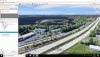
Ok real simple. i have used this in the past with no problems. maybe a month ago was the last time.


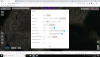
Now when i go into earth, make a simple mission, export as KML, import to litchiHub, make small tweaks and then export as a CSV to view in Earth my elevations go up thousands of feet? exporting as a 3d path it looks fine!?

attached are a few screen shots.
70790

70785707877078870789
 

Attachments

  • Screenshot (18).png
    Screenshot (18).png
    2.4 MB · Views: 31
  • Screenshot (20).png
    Screenshot (20).png
    1.2 MB · Views: 30
Why would you export them as a CSV file if you want to view them in Google Earth?
it has always in the past created the virtual flight to preview, i mean it still does just thousands of feet to high !
 
But exporting as a KML will achieve the same thing without all the redundant additional fields that are in the mission description.
how do i get google earth to fly a virtual path with a KML file?
 
might not be the best video but if you jump to the 5:30 mark he shows you what a CSV file does in earth. I never had issues untill now.

even reinstalled earth thinking something got messed up

 
  • Like
Reactions: SGM
Here's a tutorial I did using VLM. I now use the Google Chrome plugin for VLM instead of the Windows App.
 
  • Like
Reactions: bobfa100
see thats just it, iv had the Litchi virtual mission extension on my pc as well. but when it goes into earth now you can see it flys in the way of pass anger jets LOL.

Before today i have had NO issues at all!
 
see thats just it, iv had the Litchi virtual mission extension on my pc as well. but when it goes into earth now you can see it flys in the way of pass anger jets LOL.

Before today i have had NO issues at all!
Give me a second, I'll check mine and see if anything has changed.
 
  • Like
Reactions: bcarriveau
Does it with all my old missions also. Just uninstalled and reinstalled Pro again and still puts the VLM a few thousand feet in the air ?
 
Give me a second, I'll check mine and see if anything has changed.

So after downloading Virtual Litchi Mission and removing the chrome extension it renders the VLM in Earth Pro perfectly. Turned the extension back on and back to the same issue.

so the Extension is currently the problem..

@Aerial-Pixel, Were you able to take a peek and see if yours is messing up also?
 
Sorry for not getting back, yes my Chrome plugin is doing the same thing. The Windows version works fine. On the chrome plug in make sure your units are set to imperial instead of metric. for some reason my units were defaulting to metric I switched it back and it seemed to work okay but the elevation was all the way at ground level instead of the specified waypoint elevation.
 
Sorry for not getting back, yes my Chrome plugin is doing the same thing. The Windows version works fine. On the chrome plug in make sure your units are set to imperial instead of metric. for some reason my units were defaulting to metric I switched it back and it seemed to work okay but the elevation was all the way at ground level instead of the specified waypoint elevation.

yup, mine does the same, and if you try it again it goes 10 zillion feet in the air. so werid, thanks for informing me about the standalone program , i did message litchi with a link here so hopefully it can get fixed!
 
Initially same issues, but they’re fixed now ?. Saw a pop-up when clicking “Above Ground “ saying cant load elevation data.

So I loaded on old mission, and it worked as expected from Mission Hub Litchi to Google Earth.

Now new missions are working fine. May have been an error in the elevation data cache.
 
Im hopeing it's a server glitch , more scary to have their servers feeding bad elevation data lol
 
Im hopeing it's a server glitch , more scary to have their servers feeding bad elevation data lol

Remember that there are no absolute altitudes in the mission profile itself - just heights relative to the takeoff point - so it's not going to affect the actual flight.
 
  • Like
Reactions: bcarriveau
Remember that there are no absolute altitudes in the mission profile itself - just heights relative to the takeoff point - so it's not going to affect the actual flight.
Good to know, I dont know what goes on behind the scene! I'm just grateful for these amazing machines and the ability to own them!
 
Remember that there are no absolute altitudes in the mission profile itself - just heights relative to the takeoff point - so it's not going to affect the actual flight.

There are if your click the box “Relative to Ground”
 
Lycus Tech Mavic Air 3 Case

DJI Drone Deals

New Threads

Forum statistics

Threads
131,057
Messages
1,559,389
Members
160,040
Latest member
darksebius