DJI Mavic, Air and Mini Drones
Friendly, Helpful & Knowledgeable Community
Join Us Now

Problem Understanding GEO Blue Zone ?

Joined
Jul 6, 2020
Messages
14
Reactions
27
Age
35
Location
ST Thomas United States Virgin Islands
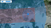
I live not too far away from the airport. I understand all the safety measures that are applied to these new drones. But this one I find very confusing. Below here is a picture of my concern. I am trying to fly my drone within the blue zone area, I have gained legal access to fly within the blue circle area. I am trying to take off where the red dot is on the screenshot. Every time I try to take off I am not allowed to take off due to the red zone above the blue zone. My concern is why allow authorization for the blue zone area if you are still going to be rejected to takeoff from the RedZone area above it? If anyone knows please help me understand I am new to drones? This is my first drone by the way
 

Attachments

  • BlueZone.PNG
    BlueZone.PNG
    1.2 MB · Views: 36
The overlapping red zone is a Restricted Zone and you can't "self unlock" there. These are usually the zones around the extended centerlines of coming off nearby runways, so drones in these areas have an increased risk.

If you really have obtained legal permission to fly in that area, you can submit it to DJI via their Custom Unlock website and they will provide your drone the unlock it needs to fly there.
 
I took another look at your intended fly spot and it's clearly in a "0" LAANC grid, meaning that it is not legal to fly there, unless you have a FAA Part 107 certificate and seek "Further Coordination" via LAANC or the FAA DroneZone site.

The "blue zone" that you can self unlock relates to the nearby Seaplane base, but the more serious airspace is that for the King Airport.

Screenshot_20200706-182324_AirMap.jpg
 
  • Like
Reactions: 2Mavics4AManiac
I have authorization for the blue circle in the screenshot, not the red. What I don't understand why have those 2 zones one on top the other? Why not make it a red zone completely? Because it makes no sense to unlock the blue zone below it if you would still be denied access from the RedZone on top of it.
 
I took another look at your intended fly spot and it's clearly in a "0" LAANC grid, meaning that it is not legal to fly there, unless you have a FAA Part 107 certificate and seek "Further Coordination" via LAANC or the FAA DroneZone site.

The "blue zone" that you can self unlock relates to the nearby Seaplane base, but the more serious airspace is that for the King Airport.

View attachment 107132
Thanks now that's a better understanding. Coming from an aviation field it shouldn't take long to pass the test for FAA Part 107 certificate.
 
I have authorization for the blue circle in the screenshot, not the red. What I don't understand why have those 2 zones one on top the other? Why not make it a red zone completely? Because it makes no sense to unlock the blue zone below it if you would still be denied access from the RedZone on top of it.

Basically DJI lists every airspace area separately, but the more restrictive airspace will still limit you. So yeah, unlocking the blue won't help until you get the documentation to fly in the red.
 
I was told of an app of some sort that you can create a flight plan and you can send it to the airport ATC and ask for approval. This is of course if you have the Part 107 - Remote Pilot Certificate. I have a friend who i think still works in our airport ATC. My question how does this app send the flight plan to our local ATC?
 
I was told of an app of some sort that you can create a flight plan and you can send it to the airport ATC and ask for approval. This is of course if you have the Part 107 - Remote Pilot Certificate. I have a friend who i think still works in our airport ATC. My question how does this app send the flight plan to our local ATC?

He's talking about one of the apps for the LAANC system. The two most popular are AirMap and Kittyhawk. Both are free and available for ios and Android.

You can use these apps as either a recreational pilot or as a Part 107 pilot, but only Part 107 pilots can request permission to fly above the listed grid altitudes. Since the area you posted above is in a "0" grid, only a Part 107 pilot has the ability to get permission to fly there.

There are some areas in controlled airspace further away from the airport where you could get permission even as a recreational pilot though, up to 400 feet depending on the location.

Ohh major thanks for this info. I am so happy i found this forum. I'm getting better info than DJI could ever provide. Did it took long to get the 107? Also, where do I apply for it?
 
Ohh major thanks for this info. I am so happy i found this forum. I'm getting better info than DJI could ever provide. Did it took long to get the 107? Also, where do I apply for it?

Well, I already had my Private Pilot certificate, so learning the material for the Part 107 test was pretty quick and easy for me. (it was a lot of learning how to read aeronautical charts, weather questions, etc, stuff that I already knew or could quickly refresh my memory on). I mainly just used some free resources I found online to study for the test. But if you are more rusty, there are several paid online Part 107 "Ground schools" that can teach you all the things you need to know.

Once you feel that you are ready, you can schedule the test online via the FAA's testing center partner, PSI. The test itself has to be taken at a testing facility in person and costs around $150.

Also, there is a "shortcut" to getting your Part 107 certificate if you have a Part 61 certificate (like a Private Pilot one), and have had a Flight Review within the last two years, where you don't have to take the test and can just do a short online course instead , but sadly I hadn't flown an airplane in over a decade, so I had to take the actual 107 test.

The FAA's website has more info here too.
Thanks for the info. I can see this test would relate commonly to aviation. The different airspace rule etc... I will check this out. And hope to achieve getting this license to fly. As you can see the island I live on is mostly covered by different airspace considering how small the island really is.
 

DJI Drone Deals

New Threads

Forum statistics

Threads
131,095
Messages
1,559,771
Members
160,078
Latest member
svdroneshots