

Hi All, I am a new pilot. Like many others, I have been spending a lot of time learning, watching videos, reading posts, etc. before flying I have a Mavic 2 Pro and have made 1 test flight in my home (It has high ceilings). I know flying in your home is not advisable ... but I had to do it lol. I live in San Diego and flying can be challenging. Moving on ... please take a look at the attached screen shot. I am trying to figure out if I can fly here or not ... it is my home area. I get different results with Airmap vs Kittyhawk. As far as I can tell in Airmap, I am good to go without authorization up to 200 feet. IMO, I don't need authorization and can fly up to 200 feet - but I could be wrong. Your guidance is appreciated - thank you.

You are using an out of date browser. It may not display this or other websites correctly.
You should upgrade or use an alternative browser.
You should upgrade or use an alternative browser.
Question concerning Kittyhawk - can I fly here?
- Thread starter fguthrie
- Start date
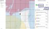

Thanks for your reply. You got me to looking closer, thanks. As far as I can tell I agree with you. The cool thing is my house is in the white area which I believe I don't need authorization for. But I see now (thanks to you) that the app is telling me that the blue area is close by and I can't fly there.I am new also, From what I see on your screen cap from Kittyhawk indicates your good to go, just don't fly into the Blue area that indicates zero feet as well as the other colored areas
Anyone else wnt to chime in? Just want to make sure us newbees have it right. Thanks!
- Joined
- Feb 22, 2017
- Messages
- 2,096
- Reactions
- 1,300
- Location
- 48°18'25"N 11°52'10"E
- Site
- skydrone-systems.com
You need LAANC authorization for the area you intend to fly.The cool thing is my house is in the white area which I believe I don't need authorization for.

Your definite source should be the FAA:
ArcGIS Web Application
 www.arcgis.com
I didn't even know about the FAA website - thanks for sharing. This is a bit misleading though, as according to both Kittyhawk and Airmap I can fly there. That doesn't give much credit to either of the apps.You need LAANC authorization for the area you intend to fly.
View attachment 87888
Your definite source should be the FAA:
ArcGIS Web Application
Hi All, I am a new pilot. Like many others, I have been spending a lot of time learning, watching videos, reading posts, etc. before flying I have a Mavic 2 Pro and have made 1 test flight in my home (It has high ceilings). I know flying in your home is not advisable ... but I had to do it lol. I live in San Diego and flying can be challenging. Moving on ... please take a look at the attached screen shot. I am trying to figure out if I can fly here or not ... it is my home area. I get different results with Airmap vs Kittyhawk. As far as I can tell in Airmap, I am good to go without authorization up to 200 feet. IMO, I don't need authorization and can fly up to 200 feet - but I could be wrong. Your guidance is appreciated - thank you.
Welcome to the forum.
In your screen shot it says "Authorized for 0 feet" which means you can't take off. An authorization tells you the MAX altitude you can fly in that section of the grid. ZERO means no fly without approval.
I don't believe that is correct. It does say not authorized, but it is referring to the blue quadrant, not where I am located. I am located in the white space which is not addressed in the notes. The green colored icon I pointed to in the map indicates I can fly there.Welcome to the forum.
In your screen shot it says "Authorized for 0 feet" which means you can't take off. An authorization tells you the MAX altitude you can fly in that section of the grid. ZERO means no fly without approval.
I don't believe that is correct. It does say not authorized, but it is referring to the blue quadrant, not where I am located. I am located in the white space which is not addressed in the notes. The green colored icon I pointed to in the map indicates I can fly there.
I'm going by what YOU posted. It says authorized to ZERO feet. Which means you have not gotten AUTHORIZATION to fly. You need to use LAANC to get authorization. Once you have that then the box will let you know what altitude you're authorized to fly in that section.
The GREEN indicates that you CAN get authorization in that section not that you HAVE authorization.
That helps me tremendously, thank you. Now I understand what the green indicates. So even though I am not in the blue area, since it is the first box in the app, I need to adhere to what it indicates for where I am located, correct?I'm going by what YOU posted. It says authorized to ZERO feet. Which means you have not gotten AUTHORIZATION to fly. You need to use LAANC to get authorization. Once you have that then the box will let you know what altitude you're authorized to fly in that section.
The GREEN indicates that you CAN get authorization in that section not that you HAVE authorization.
That helps me tremendously, thank you. Now I understand what the green indicates. So even though I am not in the blue area, since it is the first box in the app, I need to adhere to what it indicates for where I am located, correct?
Correct. It GEO LOCATES to exactly where you are via your mobile device.
Here are some MUST WATCH videos that might help clear some of the confusion:
FAA ~
Unmanned Update: Low Altitude Authorization and Notification Capability (LAANC)
Gold Seal - Airspace Authorizations Made Easy
The above might mention Part 107 but the processes are the same (mostly) just make sure you select Hobby/Recreational on yours.
Also it's important to note that the altitudes depicted on the UAS Facility Map Grids are the altitudes you're LIKELY to get approved. Those are not "Stated Approval Altitudes". Look at them as more of a guideline/template. If a grid section states 100' then there is no need to request 300' because it will get DENIED immediately. Some people have incorrectly thought that is they flew at (or below) the Grid Altitude they didn't need an actual Authorization. That's COMPLETELY wrong. Any flight in a Grid Section requires prior authorization period.
Also when just viewing and not submitting a flight plan through LAANC, it is probably showing the lowest common denominator for the entire view in your screen. At least that's how I've seen Airmap operate. Try zooming in so only the areas shown are where you plan to fly.
Each square has a max ceiling. Even Airman is stubborn in showing it. Kittyhawk color coded the squares based on allowed height.
I think you may already understand now, but you are supposed to obtain authorization through LAANC whenever flying in controlled airspace, no matter what altitude. As a hobbyist, you won't get approval if request is above the designated max ceiling.
If LAANC is not available for a controlled airspace, you need to submit your request to dronezone.faa.gov. That can take days to get approval.
brett8883
Well-Known Member
I’m not sure we are correct here guys. The facility map is set up on a grid but airspace is set up on based, typically, on circles. Of course the airspace, VFR chart, is what really matters and not the facility map.
So would really need a better reference for this location, like GPS coordinates, to figure this out but by going off of the facility map and assuming that Kittyhawk‘s representation of that airspace is correct then this location is out side of all of those surrounding airspace and is in class G airspace, a small sliver of it anyway.
You can see from this view of the facilities map that there is this sliver of class G here because there are a few squares that do not touch any airspace.

I think I have the approximate area in question’s sectional here.

Correct me if I’m wrong @BigAl07 but if he’s outside those Class D cylinders then he shouldn’t need authorization regardless of what Kittyhawk is tell him
So would really need a better reference for this location, like GPS coordinates, to figure this out but by going off of the facility map and assuming that Kittyhawk‘s representation of that airspace is correct then this location is out side of all of those surrounding airspace and is in class G airspace, a small sliver of it anyway.
You can see from this view of the facilities map that there is this sliver of class G here because there are a few squares that do not touch any airspace.
I think I have the approximate area in question’s sectional here.
Correct me if I’m wrong @BigAl07 but if he’s outside those Class D cylinders then he shouldn’t need authorization regardless of what Kittyhawk is tell him
brett8883
Well-Known Member
I assume if they wanted us to go off of the facilities chart thry would’ve made learn that for the 107 rather than all the sectionals
Great information, thank you very much.Also when just viewing and not submitting a flight plan through LAANC, it is probably showing the lowest common denominator for the entire view in your screen. At least that's how I've seen Airmap operate. Try zooming in so only the areas shown are where you plan to fly.
Each square has a max ceiling. Even Airman is stubborn in showing it. Kittyhawk color coded the squares based on allowed height.
I think you may already understand now, but you are supposed to obtain authorization through LAANC whenever flying in controlled airspace, no matter what altitude. As a hobbyist, you won't get approval if request is above the designated max ceiling.
If LAANC is not available for a controlled airspace, you need to submit your request to dronezone.faa.gov. That can take days to get approval.
I see what @brett8883 is pointing out but that's not a hair I'd be willing to split especially as a new hobbyist.
While "legally" Airspace is the determining factor I think it would be erring on the side of caution to follow the UAS Facility Grid and get that authorization unless you can confident enough to explain yourself if there is any question about it.
While "legally" Airspace is the determining factor I think it would be erring on the side of caution to follow the UAS Facility Grid and get that authorization unless you can confident enough to explain yourself if there is any question about it.
I assume if they wanted us to go off of the facilities chart thry would’ve made learn that for the 107 rather than all the sectionals
I sincerely hope they put SECTIONALS on the hobby test too. Otherwise it's useless IMHO.
The facilities map grids do go beyond the airspace circles so following the map has you covered. Besides, that's the only place for the UAS altitude ceiling. Sectionals deal with MAS ceilings and floors.
One could get and need LAANC approval if his flight plan ventures into any of the squares.
One could get and need LAANC approval if his flight plan ventures into any of the squares.
brett8883
Well-Known Member
Agreed. In this case the neighboring airspace is auto-approval with LAANC anyway so why not.I see what @brett8883 is pointing out but that's not a hair I'd be willing to split especially as a new hobbyist.
While "legally" Airspace is the determining factor I think it would be erring on the side of caution to follow the UAS Facility Grid and get that authorization unless you can confident enough to explain yourself if there is any question about it.
Sometimes I like having LAANC authorizations even if I don’t need them cause if anybody questions you you can show them something from the FAA that says you have permission to fly. kinda wish you could get that anywhere even if no controlled airspace around. Not that I am advocating for all flights to require LAANC approval to be clear. Just the OPTION to get it anywhere.
That certainly would help with authorization zone geofencing for runway approaches even in G space, particularly when DJI finally integrates LAANC into their app. But LAANC relies on ATC facilities. Many controlled airspace locations don't yet support LAANC.
Maybe I'm mistaken, but it appears that the airspace shown is a LAANC controlled airspace. I believe that Kittyhawk color codes its LAANC areas and you get altitudes actually permitted later in the authorization process. When you try to obtain authorization in a red colored box or one that is primarily red, it means you cannot fly there, thus the authorization in the warning is "0" meaning that LAANC will not approve a flight at any height. The warning says "Permissible altitude for authorization: 0 ft". I think the meaning is you can't get LAANC approval to fly at that location, not that you haven't gotten the approval yet. The difference in Airmap and Kittyhawk is that the rectangles in Airmap show the maximum permitted flight altitude numerically on the map right up front, thus "0" would mean no flight authorization even through LAANC. I believe Kittyhawk gives you this information by written warning as shown here. I believe in this case the LAANC grid and the colors or max altitudes given may supersede the areas shown by the sectionals. Though confusing, I think I would go with at least initial approval through the FAA website and even contact an FAA office to see where the priorty lies. Remember, LAANC is a newer science than the sectionals, requiring input from both the FAA and the airports controlled by it and therefore may be more up to date with area airport operations that the sectional itself.
Similar threads
- Replies
- 10
- Views
- 2K
- Replies
- 16
- Views
- 1K
- Replies
- 11
- Views
- 667
- Replies
- 10
- Views
- 940


DJI Drone Deals
1. Mini 2
2. Mini 3 Pro
3. Mini 4 Pro
4. Air 2s
5. Air 3
6. Avata 2
7. Mavic 3 Pro
8. Mavic 3 Classic
2. Mini 3 Pro
3. Mini 4 Pro
4. Air 2s
5. Air 3
6. Avata 2
7. Mavic 3 Pro
8. Mavic 3 Classic
New Threads
-

-
-
Hello everyone! New aspiring drone pilot here, from Portugal.
- Started by Rui S
- Replies: 4
-

-
Forum statistics
