DJI Mavic, Air and Mini Drones
Friendly, Helpful & Knowledgeable Community
Join Us Now

Rules and regs in Spain

NEILMAC

Member
Joined
Nov 30, 2020
Messages
6
Reactions
2
Age
69
Location
Spain
Hi, complete newbie here...

Having just bought a Mini 2 Fly More Combo I'm busy trying to understand where I'm going to be able to fly it. So far I have looked at drones.enaire.es to try and understand their mapping and also dji's flysafe mapping which seems to be much more lenient when it comes to restricted areas.

I live in Spain in a little village and although out in the sticks a bit, Enaires mapping puts me within 8km of an aerodrome (small place that does a bit of microlight training and flying) and next to some protected natural areas.

So really, what I'd like to understand is whether I'm likely to be able to get any kind of permission to fly a recreational <250g drone with a camera in these areas or are they just 'out of bounds' full-stop?
ENAIRE-Drones.png


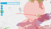
Image shows my location and surrounding areas on the Enaire mapping.

It its possible to get permissions how do I start finding out who to contact?

Anyone dealt with similar?
 
  • Like
Reactions: Chris4koi
As a recreational pilot you can only fly in the uncoloured areas. Flying in the 8km zone of the microlight airspace requires permission from the airfield. You have to show registered operators permit, insurance, pilots certificate and provide a flight plan with time and date of the flight. Then notify the airfield before and after the flight.

The national parks are similar, you require AESA approval and permission from the park authorities. Same paperwork as the airfields.

Theres plenty of open areas near you where it’s possible to fly a drone. I used to live South Alicante where there is very little space available for recreational pilots.

The mini 2 can be used near people and property at a maximum high of 20m. So it can be used most places in the grey areas with care.

Recreational pilots are also required to fit ID plates to the drone. Operators name, telephone number, serial number, type of drone. They can be had with a Google search for ¨Placa de drone¨ Cost about 15€ for 2 plates. One each for the drone and controller.
Thanks very much for all that. I think I'll be quite happy outside the restricted areas. I've ordered the ID plates now. Much appreciated.
 
As a recreational pilot you can only fly in the uncoloured areas. Flying in the 8km zone of the microlight airspace requires permission from the airfield. You have to show registered operators permit, insurance, pilots certificate and provide a flight plan with time and date of the flight. Then notify the airfield before and after the flight.

The national parks are similar, you require AESA approval and permission from the park authorities. Same paperwork as the airfields.

Theres plenty of open areas near you where it’s possible to fly a drone. I used to live South Alicante where there is very little space available for recreational pilots.

The mini 2 can be used near people and property at a maximum high of 20m. So it can be used most places in the grey areas with care.

Recreational pilots are also required to fit ID plates to the drone. Operators name, telephone number, serial number, type of drone. They can be had with a Google search for ¨Placa de drone¨ Cost about 15€ for 2 plates. One each for the drone and controller.
The ID plates are a must for drones in Spain. I have both the Mini 2 and the M2Z and each time I have been approached by the police the first thing they ask to see is the ID plate both on the drone itself and also on the remote.
 
  • Like
Reactions: cacuaca and NEILMAC
In any case, the Spanish and European regulations will change on January 1 2021, and some things such as the use of identification plates on the drone and the remote controller will no longer be necessary. Below is the AESA link with info about the new regulations (it's in Spanish).

 
  • Like
Reactions: OldGuy and cacuaca
In any case, the Spanish and European regulations will change on January 1 2021, and some things such as the use of identification plates on the drone and the remote controller will no longer be necessary. Below is the AESA link with info about the new regulations (it's in Spanish).

Correct , on januari 1st all EU member states will have to adopt at the new EU regulations and no identification plates will be necessary , but all drones above 250gr. wil have to send out an electronic ID/Geo awareness ...

2020-12-20_23-01-20.jpg
 
  • Like
Reactions: ASanzF
Its worth mentioning that no matter where you are in the world, never rely on the DJI Flysafe/geo to determine if you can fly somewhere or not.
Its bare bones basic and misses almost all the restrictions in some places.
 
  • Like
Reactions: cacuaca
Hi, complete newbie here...

Having just bought a Mini 2 Fly More Combo I'm busy trying to understand where I'm going to be able to fly it. So far I have looked at drones.enaire.es to try and understand their mapping and also dji's flysafe mapping which seems to be much more lenient when it comes to restricted areas.

I live in Spain in a little village and although out in the sticks a bit, Enaires mapping puts me within 8km of an aerodrome (small place that does a bit of microlight training and flying) and next to some protected natural areas.

So really, what I'd like to understand is whether I'm likely to be able to get any kind of permission to fly a recreational <250g drone with a camera in these areas or are they just 'out of bounds' full-stop?

View attachment 118523


Image shows my location and surrounding areas on the Enaire mapping.

It its possible to get permissions how do I start finding out who to contact?

Anyone dealt with similar?
Well things are not looking very good in Spain or indeed the rest of the EU - was just looking at this website this afternoon and as you will see it is going to be a lot more difficult and expensive to fly a drone after the 31st December 2020 and Brexit can't be blamed on this one. Get ready for the new Drones Regulation! | EASA
 
EASA regulations are a significant loosening restrictions for lots of countries including the UK.
Its the exact opposite of "more difficult" and "more expensive"
 
EASA regulations are a significant loosening restrictions for lots of countries including the UK.
Its the exact opposite of "more difficult" and "more expensive"
Sorry but that is not the case for non commercial - hobby drone pilots
 
Sorry but that is not the case for non commercial - hobby drone pilots

Quite simply it is for most countries. Some have gone from huge restrictions to far more open and free.
Distance limits have gone, built up area restrictions, some types can go a lot closer to people if required, and so on.
It also allows commercial flights without having to pay hundreds or thousands of pounds.
Its a big improvement for the UK, Greece and other places.
 
Hi guys, very new here.
I'm from Zaragoza and I'm having some troubles understanding some of the rules we have here in Europe.
I'd like to fly over a zone that is declared "historical set" (conjunto histórico) but has no limitations from EASA.
I've contacted them to obtain the permissions (not that I thought I needed it, just to make sure they knew about it) and they replied that I'll have to ask the permission to the Government and pay a tax for filming. The document they sent me is about occupying the public ground and for entering the historical set.
I've told them that I'm not going to enter the set neither to occupy the ground, as I will fly from a nearby street, from an elevated position, where I'll have full visual of the drone during all the fly, but they didn't answer back.

The question is: can they somehow close the air space on top of the set if EASA doesn't publish any limitation?

Another example is a monastery that you can visit by paying a fee. They have signs all over the place saying that you cannot fly drones.
Again, the zone has no restrictions whatsoever from EASA and I'd like to fly over it without entering the park. Can they close their air space?
 
I've been studying the ENAIRE map for possible places to fly in Toledo, Avila and Segovia.

There are lot of red zones in the ENAIRE map, over most cities and towns of any size.

But the red zones do not have the same meaning. When you click on the red zones around central Madrid or Barcelona, they all say RPAS flight prohibited, in red. So no ambiguity there.

But in some cities, the red zones say it's in aerodrome space. For instance, two big red circular zones over Toledo and each one corresponds to some aerodrome.

How do you get clearance with aerodromes, call them up before you fly and ask if you can?
ENAIRE usually gives you a phone number or an email address to contact the aerodrome. Just call them and tell them what you want to do and when. They'll tell you what they need to authorize you (usually your operator number, insurance, phone number, etc).
In an airport zone it's more difficult. You need to have a radio-operator license, a radio, prepare a risk assessment plan and ask AESA for permission.
 
Hey guys. I'm just vacationing on Spain for three months, and I've been wondering how I can get to fly here. I'm in Barcelona.

As a foreigner, what should I do in order to get permission to fly?
 
Hey guys. I'm just vacationing on Spain for three months, and I've been wondering how I can get to fly here. I'm in Barcelona.

As a foreigner, what should I do in order to get permission to fly?
You need to be registered as an operator to AESA. Here is the English page.
Then you need to attach an aluminum plate with your Operator No., Phone no., UAS type and serial no. to your drone and remote. Something like this.
If your drone is over 250g of weight, you also need to take an online exam for the A1/A3 subcategories (it's free).
You need an insurance that covers you in Spain too.
Then you can go to ENAIRE web site and check if you can fly where you are.
As you will see, in Barcelona is almost impossible to fly, due to a big airport and various heliports all around the city, so you'll have to move a little out of that zone.
Here is the AESA page in English.
Hope it helps.
 
Lycus Tech Mavic Air 3 Case

DJI Drone Deals

New Threads

Forum statistics

Threads
131,053
Messages
1,559,345
Members
160,035
Latest member
turtle27mike