DJI Mavic, Air and Mini Drones
Friendly, Helpful & Knowledgeable Community
Join Us Now

SkyeBrowse now offers a free version of its drone 3D modeling app

Jagerbomb52

Well-Known Member
Joined
Apr 6, 2018
Messages
1,483
Reactions
2,321
Location
Canada
Though the free version of the app supports limited features, it still allows users to fly a mission using a supported DJI or Autel drone and upload the video to generate a basic 3D model at no cost. Users can also fly a wide-range mapping WideBrowse mission under the freemium model. According to SkyeBrowse, WideBrowse can map up to 50 acres in five minutes.

 
  • Like
Reactions: Tufargon
I just saw this and came to check the forum. Is there anyone here that has tried it and found value for the hobbyist? Seems cool. Also, how reliable is it? Assuming it uses the SDK and flies your drone for the mission.
 
Working with the support team from skyebrowse on a solution for the App crashing on my Tripltek tablet today. So far no improvements. Have it running on my S20 ultra 5G phone and runs well. Did 2 flights at my local ballpark. Since I don't have unlimited data I needed to upload the video from the SD card to their site. Almost 3 hours later it's still uploading. So far I see no advantage to this software.
 
  • Sad
Reactions: Tufargon
I was having high hopes on this. It works on my tablet and phone but I haven't tried a flight with it.
 
I was having high hopes on this. It works on my tablet and phone but I haven't tried a flight with it.
Ya well still uploading. As you know my internet is very slow for high speed. :(
This might be user error as I have not watched all the tutorial videos. Perhaps I could have used a lower resolution. The way I thought about it the higher resolution the better the final product.
Will let this go till its done. One thing my emails get answered pretty fast and they seem to want to solve the tablet problem so they keep working with me which is good.
Also I told them with all the problems I have been having the two week free premium ran out and i never had a chance to try it out. They said they would add more time to my account once we figure this out so they seem to be a trying. hard to make things work right.
 
  • Like
Reactions: Tufargon
Looking forward to seeing it. Sounds like good support for sure.
 
Well after 4-5 hours of uploading my video to the site the upload line turned red. Knowing that red does not mean a good thing I waited about 30 minutes more and it died on me after that.
Seems there is a lot of bugs to work out. If I find some time to get into this more I will post more but for now its a very big disappointment for the average user.
 
Could you see the upload speed? Do you think it was your end or the server?
 
Oh, I did read that when you first made the thread. Hopefully they fix that. I'll try to get out and see how it works (if it works) for when I get time.
 
Uploaded again this morning. This was a larger file size. This took 4.5 hours to upload to their site. I don't have fiber but it is a high speed connection to my ISP. Doing models to Maps Made Easy the upload was faster but the render time worked out to about the same. It would be nice if they added a pause option for uploading.
For a free option I guess it works pretty well.
Complete name : F:\Air 2S\Apps Folder\Freebe\DJI_0113.MP4
Format : MPEG-4
Format profile : Base Media
Codec ID : isom (isom/iso2/mp41)
File size : 1.65 GiB
Duration : 2 min 16 s
Overall bit rate : 103 Mb/s
Encoded date : UTC 2022-10-30 18:03:06
Tagged date : UTC 2022-10-30 18:03:06
Writing application : Lavf56.15.102

Video
ID : 1
Format : HEVC
Format/Info : High Efficiency Video Coding
Format profile : Main 10@L5@Main
Codec ID : hvc1
Codec ID/Info : High Efficiency Video Coding
Duration : 2 min 16 s
Bit rate : 103 Mb/s
Width : 3 840 pixels
Height : 2 160 pixels
Display aspect ratio : 16:9
Frame rate mode : Constant
Frame rate : 29.970 (30000/1001) FPS
Original frame rate : 29.000 FPS
Color space : YUV
Chroma subsampling : 4:2:0
Bit depth : 10 bits
Bits/(Pixel*Frame) : 0.416
Stream size : 1.65 GiB (100%)
Encoded date : UTC 2022-10-30 18:03:06
Tagged date : UTC 2022-10-30 18:03:06
Color range : Limited
Color primaries : BT.2020
Transfer characteristics : HLG
Matrix coefficients : BT.2020 non-constant
Codec configuration box : hvcC
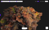
3D model link.

 
  • Like
Reactions: Tufargon
In the last day or so, Skyebrowse released an update. It now works on the RC Pro. Pilot Institute has a free class that I advise watching. The app is not intuitive. I just did a quick model of the woods behind my house.
 

Attachments

  • Screenshot 2022-11-04 12.35.52 PM.png
    Screenshot 2022-11-04 12.35.52 PM.png
    1.3 MB · Views: 22
  • Like
Reactions: Jagerbomb52
Ya I updated yesterday. Thought they might of resolved the App crashing on my Tripltek tablet as I emailed them and sent in a report to them. They said they will get it fixed but so far it still crashes. Works fine on my S20 ultra 5G phone .
 
I just saw this and came to check the forum. Is there anyone here that has tried it and found value for the hobbyist? Seems cool. Also, how reliable is it? Assuming it uses the SDK and flies your drone for the mission.
Hi
I tried it and it works ok. There are a few bugs I guess they have to deal with.
1. After I updated from original v1, I could not use without internet access.
2. Map window needs internet access to display and setup 2 circles for scan area.
3. Little problem with creating Model of scanned area.

Rest of it is ok and easy to use. Very fast respons from developer.
 
The last update I took last night has resolved the App from crashing on my Tripltek 7" tablet. Over the last two weeks I have had several updates to the App but this one finally fixed the problem.
Although I feel I can get better resolution from other photogrammetry Apps that use photos, Skyebrowse is a pretty simple to use program and does a fairly good job. The biggest problem is your internet connection speed.
 
  • Like
Reactions: Lespaxvera
I finally got around to trying this (free version). The free version no longer allows the WideBrowse option, only the circular option. Results were marginal, but done from 200' AGL, so lower altitudes might yield better results.

I probably won't use it again, and I'm unable to find where my flight log from this flight is located for retrieval/upload to AirData.
 
Lycus Tech Mavic Air 3 Case

DJI Drone Deals

New Threads

Forum statistics

Threads
131,052
Messages
1,559,336
Members
160,034
Latest member
oshgeo